The British Army was a volunteer force when war broke out in 1914, and within weeks thousands of Irishmen had signed up to serve 'King and Country'.
Ireland had a strong military tradition in the British armed forces, dating back to at least the early 1500s, and when war was declared on August 4, 1914, there were some 20,000 Irishmen already serving from a total army strength of some 247,000.
In addition, there were another 30,000 in the first-line reserve, from a total of 145,000.
But more were quickly needed. Secretary for War Lord Kitchener told the British cabinet that it would be a three-year conflict requiring at least one million men, meaning a recruitment drive was immediately undertaken.
Posters quickly appeared across the country, focused on attracting men from all background
Some appealed to a sense of duty and honour, but appeared to be aimed at British-born nationals rather than Irishmen.
-

 Superb vintage WW1 recruitment poster imploring the young men of Ireland to join the British Army.The poster depicts a lone piper with the famous mascot of the Royal Irish Regiment ,an Irish Wolfhound. 47cm x 38cm Nenagh Co Tipperary
 -
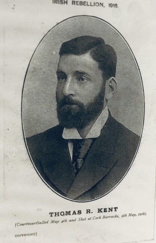
 Beautiful and poignant collection of four of the 1916 Easter Rising Rebel Leaders who were executed by the British Crown Forces at Kilmainham Jail a few weeks later.Featured here are Padraig Pearse,Thomas Clarke,James Connolly,Thomas Kent Thomas Kent (Irish: Tomás Ceannt; 29 August 1865 – 9 May 1916) was an Irish nationalist who was court-martialled and executed following a gunfight with the Royal Irish Constabulary (RIC) on 9 May 1916, in the immediate aftermath of the Easter Rising.
Easter Rising
Kent was part of a prominent nationalist family who lived at Bawnard House, Castlelyons, County Cork. They were prepared to take part in the Easter Rising, but when the mobilisation order was countermanded, they stayed at home. The rising nevertheless went ahead in Dublin, and the RIC was sent to arrest well-known sympathizers throughout the country, including known members of the Irish Republican Brotherhood, Sinn Féin, and the Irish Volunteers. When the Kent residence was raided they were met with resistance from Thomas and his brothers Richard, David and William. A gunfight lasted for four hours, in which an RIC officer, Head Constable William Rowe, was killed and David Kent was seriously wounded. Eventually the Kents were forced to surrender, although Richard made a last minute dash for freedom and was fatally wounded.Trial and execution
Thomas and William Kent were tried by court martial on the charge of armed rebellion. William was acquitted, but Thomas was sentenced to death. David Kent was brought to Dublin where he was charged with the same offence, found guilty and sentenced to death, but the sentence was commuted and he was sentenced to five years penal servitude. Thomas Kent was executed by firing squad in Cork on 9 May 1916, the only person outside of Dublin to be shot for his role in the events surrounding Easter Week (Roger Casement was hanged for treason in London). Kent was buried in the grounds of Cork Prison, formerly the Military Detention Barracks at the rear Collins Barracks, Cork (formerly Victoria Barracks). The former army married quarters to the rear of Collins Barracks are named in his honour.State funeral
Taoiseach Enda Kenny offered a state funeral to the Kent family early in 2015, which they accepted. Kent's remains were exhumed from Cork prison in June 2015 after being buried for 99 years. The analysis of Kent's remains, which had been found in a shallow, quicklime-filled grave, involved the State Pathologist's Office, the National Forensic Coordination Office at the Garda Technical Bureau, Forensic Science Ireland, and scientists from University College Dublin, and the scientific team was led by Dr. Jens Carlsson from the University of California-Davis. The State funeral was held on 18 September 2015 at St Nicholas' Church in Castlelyons. Kent lay in state at Collins Barracks in Cork the day before. The requiem mass was attended by President Michael D. Higgins, with Enda Kenny delivering the graveside oration.Memorials
The main railway station in Cork, Kent Station was named after Thomas Kent in 1966. The bridge over the River Blackwater in Fermoy, Co. Cork, where Thomas Kent was detained following his arrest, was named after him and his brothers in 2016.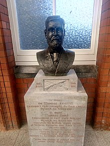 Bust of Kent at Cork Kent railway station by sculptor James MacCarthy.
 -
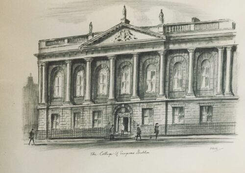
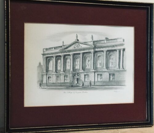 Beautiful print of the Royal College of Surgeons on St Stephens Green Dublin by the artist Judges. Dublin. 27cm x 32cm
 -
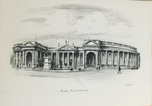
 Beautiful print of the Bank of Ireland ,College Green (formerly the old House of Parliament,built in 1729 and the worlds first purpose built bicameral Parliament House.) Origins: Dublin Dimensions :27cm x 32cm
 -
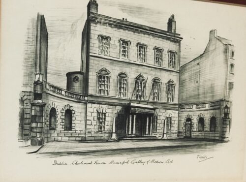
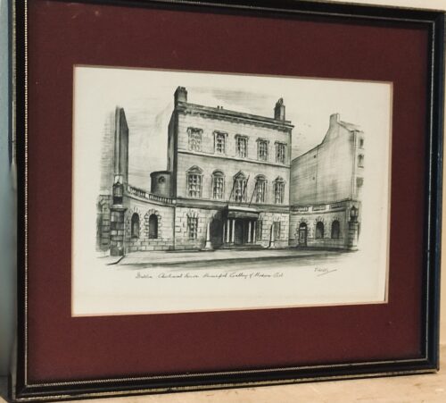 Beautiful print of the Municipal Gallery of Modern Art at Charlemont House in Dublin. Dublin 27cm x 32cm
 -
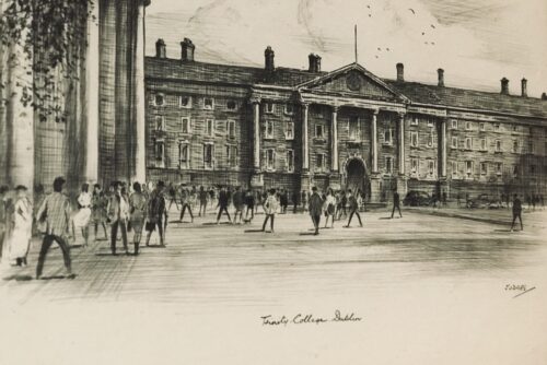
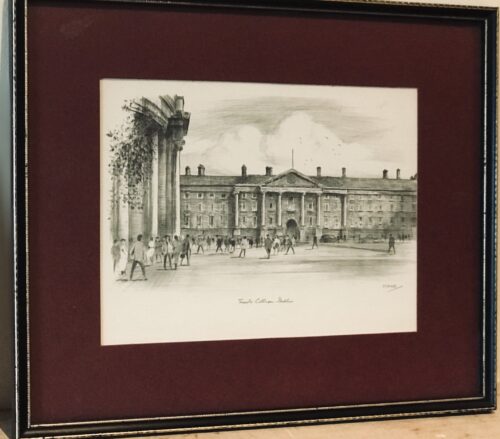 Beautiful print of the Trinity College Dublin Front Gate from the aspect of College Green by the artist known as Judges. Dublin 27cm x 32cm
 -
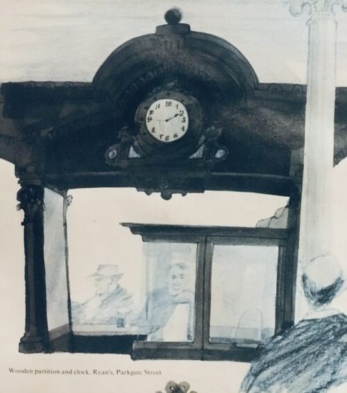
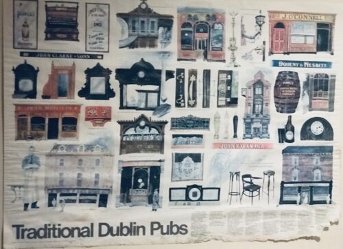 Large,colourful,beautifully illustrated and wonderfully eclectic poster depicting some of the best and most iconic Dublin watering holes.This superb poster depicts a variety of the facades,architectural features and idiosyncrasies of many of the best and most celebrated traditional Dublin public houses.Favourite watering holes featured here include; The Stags Head of Dame Court,O'Connells of South Richmond St ,Ryans of Parkgate St, Doheny & Nesbitts of Baggott St ,Ryans of Haddington Road,Slatterys of Rathmines, The Palace Bar of Fleet St,McDaids off Grafton St,Kehoe' s of South Anne St,The International Bar, The Brazen Head,Mulligans of Poolbeg St and Madigans of North Earl St to name but a few. Its fair to say another 50 of these posters could have been commissioned and you still wouldn't run out of timeless classic Dublin watering holes. 57cm x 84 cm
 -
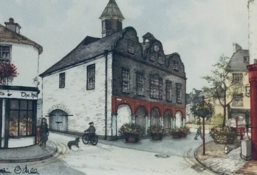
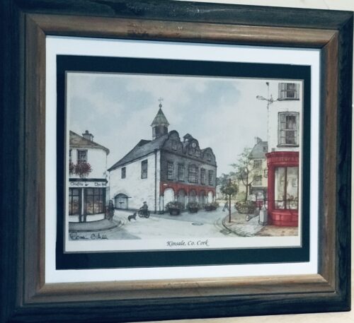 Beautiful depiction of Kinsale Co Cork These beautiful quaint scenes from six individual towns were originally table and have been superbly mounted and framed to create a memorable souvenir collection.Originally painted by talented local artist Roisin O Shea,the prints depict everyday scenes of streetlife in Killarney,Kilkenny,Blarney,Galway,Kinsale and Youghal. Lahinch Co Clare 33cm x 39cm
 -
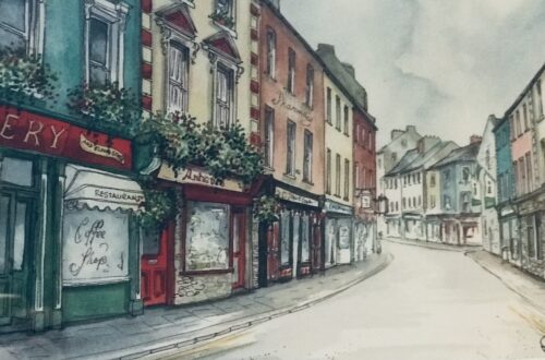
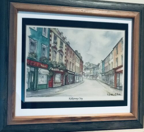 Beautiful depiction of Kilkenny City. These beautiful quaint scenes from six individual towns were originally table and have been superbly mounted and framed to create a memorable souvenir collection.Originally painted by talented local artist Roisin O Shea,the prints depict everyday scenes of streetlife in Killarney,Kilkenny,Blarney,Galway,Kinsale and Youghal. Lahinch Co Clare 33cm x 39cm
 -
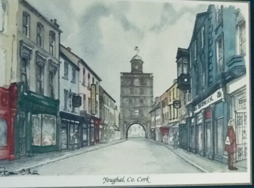
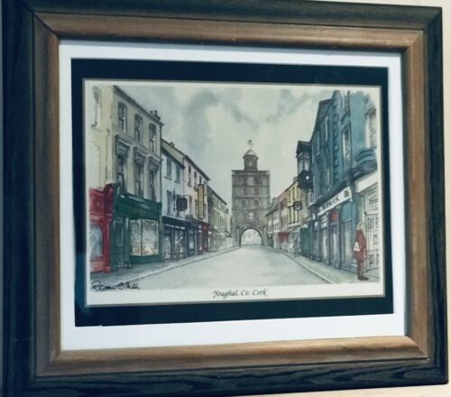 Beautiful depiction of Youghal Co Cork. These beautiful quaint scenes from six individual towns were originally table and have been superbly mounted and framed to create a memorable souvenir collection.Originally painted by talented local artist Roisin O Shea,the prints depict everyday scenes of streetlife in Killarney,Kilkenny,Blarney,Galway,Kinsale and Youghal. Lahinch Co Clare 33cm x 39cm
 -
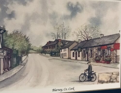
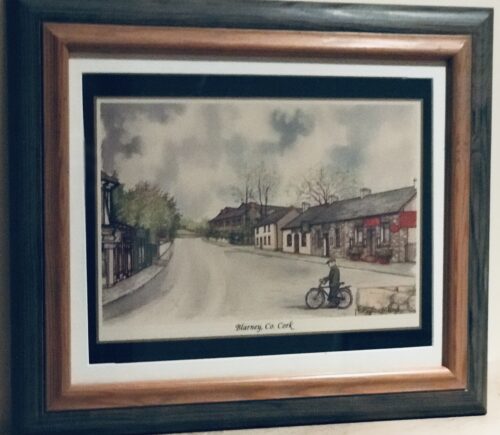 Beautiful depiction of Blarney Co Cork. These beautiful quaint scenes from six individual towns were originally table and have been superbly mounted and framed to create a memorable souvenir collection.Originally painted by talented local artist Roisin O Shea,the prints depict everyday scenes of streetlife in Killarney,Kilkenny,Blarney,Galway,Kinsale and Youghal. Lahinch Co Clare 33cm x 39cm
 -
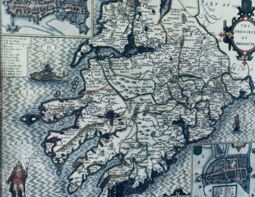
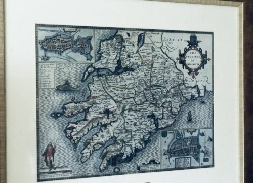 Fascinating map from 1610 as by the renowned cartographer John speed of the Province of Mounster(Munster!)-comprising the counties of Tipperary,Clare,Limerick,Cork,Kerry & Waterford.Includes miniature city layouts of both Limerick & Cork. 52cm x 65cm Beaufort Co Kerry John Speed (1551 or 1552 – 28 July 1629) was an English cartographer and historian. He is, alongside Christopher Saxton, one of the best known English mapmakers of the early modern period.
Life
Speed was born in the Cheshire village of Farndon and went into his father Samuel Speed's tailoring later in life. While working in London, Speed was a tailor and member of a corresponding guild, and came to the attention of "learned" individuals. These individuals included Sir Fulke Greville, who subsequently made him an allowance to enable him to devote his whole attention to research. By 1598 he had enough patronage to leave his manual labour job and "engage in full-time scholarship". As a reward for his earlier efforts, Queen Elizabethgranted Speed the use of a room in the Custom House. Speed, was, by this point, as "tailor turned scholar" who had a highly developed "pictorial sense". In 1575, Speed married a woman named Susanna Draper in London, later having children with her. These children definitely included a son named John Speed, later a "learned" man with a doctorate, and an unknown number of others, since chroniclers and historians cannot agree on how many children they raised. Regardless, there is no doubt that the Speed family was relatively well-off. By 1595, Speed published a map of biblical Canaan, in 1598 he presented his maps to Queen Elizabeth, and in 1611–1612 he published maps of Great Britain, with his son perhaps assisting Speed in surveys of English towns. At age 77 or 78, in August 1629, Speed died. He was buried alongside his wife in London's St Giles-without-Cripplegate church on Fore Street. Later on, a memorial to John Speed was also erected behind the altar of the church.According to the church's website, "[His was] one of the few memorials [in the church] that survived the bombing" of London during The Blitz of 1940–1941 ... The website also notes that "[t]he cast for the niche in which the bust is placed was provided by the Merchant Taylors' Company, of which John Speed was a member". His memorial brass has ended up on display in the Burrell Collection near Glasgow.Works
Speed drew historical maps in 1601 and 1627 depicting the invasion of England and Ireland, depictions of the English Middle Ages, along with those depicting the current time, with rough originals but appealing, colourful final versions of his maps. It was with the encouragement of William Camden that Speed began his Historie of Great Britaine, which was published in 1611. Although he probably had access to historical sources that are now lost to us (he certainly used the work of Saxton and Norden), his work as a historian is now considered secondary in importance to his map-making, of which his most important contribution is probably his town plans, many of which provide the first visual record of the British towns they depict.In the years leading up to this point, while his atlas was being compiled, he sent letters to Robert Cotton, part of the British government to ask for assistance in gathering necessary materials.His atlas The Theatre of the Empire of Great Britaine was published in 1611 and 1612, and contained the first set of individual county maps of England and Wales besides maps of Ireland and a general map of Scotland. Tacked onto these maps was an introduction at the beginning when he addressed his "well affected and favourable reader", which had numerous Christian and religious undertones, admitting that there may be errors, but he made it the best he could, and stated his purpose for the atlas: In 1627 George Humble published the Prospect of the Most Famous Parts of the World, printed by John Dawson. This is the world map from this atlas with John Speed's name in the title, but not attributed to Speed's authorship.
my purpose...is to shew the situation of every Citie and Shire-town only [within Great Britain]...I have separated...[with] help of the tables...any Citie, Towne, Borough, Hamlet, or Place of Note...[it] may be affirmed, that there is not any one Kingdome in the world so exactly described...as is...Great Britaine...In shewing these things, I have chiefly sought to give satisfaction to all.
With maps as "proof impressions" and printed from copper plates, detail was engraved in reverse with writing having to be put on the map the correct way, while speed "copied, adapted and compiled the work of others", not doing much of the survey work on his own, which he acknowledged.The atlas was not above projections of his political opinions" Speed represented King James I as one who unified the "Kingdoms of the British isles". In 2016, the British Library published a book, introduced by former MP Nigel Nicolson and accompanied by commentaries by late medieval and early modern historian Alasdair Hawkyard, which reprinted this collection of maps on the British Isles, showing that Speed had drawn maps of areas ranging from Bedfordshire to Norfolk and Wales. Most, but not all, of the county maps have town plans on them; those showing a Scale of Passes being the places he had mapped himself. In 1627, two years before his death, Speed published Prospect of the Most Famous Parts of the World which was the first world atlas produced by an Englishman, costing 40 shillings, meaning that its circulation was limited to "richer customers and libraries", where many survive to this day. There is a fascinating text describing the areas shown on the back of the maps in English, although a rare edition of 1616 of the British maps has a Latin text – this is believed to have been produced for the Continental market. Much of the engraving was done in Amsterdam at the workshop of a Flemish man named Jodocus Hondius, with whom he collaborated with from 1598 until 1612, with Hondius's sudden death, a time period of 14 years.His maps of English and Welsh counties, often bordered with costumed figures ranging from nobility to country folk, are often found framed in homes throughout the United Kingdom. In 1611, he also published The genealogies recorded in the Sacred Scriptures according to euery family and tribe with the line of Our Sauior Jesus Christ obserued from Adam to the Blessed Virgin Mary, a biblical genealogy, reprinted several times during the 17th century. He also drew maps of the Channel Islands, Poland, and the Americas, the latter published only a few years before his death. On the year of his death, yet another collection of maps of Great Britain he had drawn the year before were published. Described as a "Protestant historian", "Puritan historian" or "Protestant propagandist" by some, Speed wrote about William Shakespeare, whom he called a "Superlative Monster" because of certain plays, Roman conquest, history of Chester, and explored "early modern concepts of national identity". As these writings indicate, he possibly saw Wales as English and not an independent entity. More concretely, there is evidence that Speed, in his chronicling of history, uses "theatrical metaphors" and his developed "historiographic skill" to work while he repeats myths from medieval times as part of his story.Legacy
Since his maps were used in many high circles, Speed's legacy has been long-reaching. After his death, in 1673 and 1676, some of his other maps on the British isles, the Chesapeake Bay region, specifically of Virginia and Maryland, the East Indies, the Russian Empire then ruled by Peter the Great, Jamaica, and Barbados, among other locations.With these printings and others, Speed's maps became the basis for world maps until at least the mid-eighteenth century, with his maps reprinted many times, and served as a major contribution to British topography for years to come. In later years, Speed would be called "our English Mercator", a person of "extraordinary industry and attainments in the study of antiques", an "honest and impartial historian", a "faithful Chronologer", and "our Cheshire historian...a scholar...a distinguished writer on history".He was also called a "celebrated chronologer and histographer", "cartographer", and much more. Even today, prints of his "beautiful maps" can be found in living rooms across the world, and sell for hundreds of thousands of pounds in rare art and map auctions, drawing in map collectors across the globe.Additionally, some use John Speed's maps, and connected commentary, to interpret William Shakespeare's plays; however, Speed did not like Shakespeare in the slightest, and called him a "papist".

