• Extremely unusual & culturally significant historical sign from a once famous pub in Castlebar Co Mayo, the historic and now sadly closed down Humbert Inn.Please email us directly to enquire about this most unusual item at irishpubemporium@gmail.com. "Located on the Main Street of Castlebar, The Humbert Inn  excelled in its hospitality to the public for over 200 years. Its name was derived from the fact that the French General Jean Humbert with his second in command General Sarrazin located their headquarters within the building during the United Irishmen rebellion of 1798. Originally until 1912 due to rates purposes, the premises also consisted of what is known today as Paddy Fahey’s shop and over the years has been used as hotel, restaurant and public house. In 1798 the site of Paddy Fahey’s and the Humbert Inn was known as Geevy’s Hotel. A banquet was held there after the 1798 Rising and it was in The Humbert Inn premises, that John Moore was declared first President of Connaught! The public bar was unique in appearance with its interior rough cut stone walls, arches, Liscannor stone floor and a façade that has changed little over the past fifty years.

    The premises has changed hands many times over the years, more recent owners including Tom Coucil, the Moran family and since 1994 John Connaughton, more popularly known as 'John Humbert'. While memories aplenty abound about The Humbert Inn with many instances of people today stating that they are the third generation of their family to call into The Humbert.  Its lasting legacy will be an outstanding and legendary venue for all that is musical. The Humbert Inn was long associated with encouraging local musicians and providing the public with a steady stream of talent. Everything from traditional sessions to Industrial Rock has been catered for, everything from one guitar, 6 piece bands to many DJs have enthralled weekly audiences! In many cases their audience trying for a pint, while singing and dancing at the same time. Always a multi-talented bunch, The Humbert regulars! The most historically famous of these bands will be 'General Humbert' consisting of Steve Dunford (bodhran, bones), John Donegan (mandolin, harmonium), Ruairi Somers (uileann pipes, tin whistles, bagpipes), Shay Kavanagh (guitar, bouzouki) and one Miss Mary Black (vocals, bodhran) from approx 1972 until 1982. Mary Black’s brother Mick was working with the then P&T in Castlebar, he along with his brother Shay informed a group of Humbert musicians including, John Hoban and Frank O’Reilly, that he 'had a sister that could sing a bit (brotherly understatement) and would they be interested if she sang with them'. Mary Black may have received her first taste of success with 'General Humbert' in the ‘70s and recorded her first album in 1982. But, along with playing venues in Dublin, she started out singing in Castlebar with traditional group 'La Salle' which included John Dunford and Fintan Murphy within The Humbert a good ten years before her international success. Christmas in particular was always memorable in The Humbert, it was a major home coming venue and meeting place. If you were brought up in Castlebar, were of a certain age, then chances were there was one of two places you would have been found on Christmas Eve, The Humbert or Rays!. The Humbert Inn can also boast its very own VIP list among its regulars with two crowned Roses of Tralee Mindy O’Sullivan and Aoibhinn Ni Shulleabhain along with Fair City actress Vicky Burke. Plus any number of quality customers, musicians, fine sportsmen and women, business people and the odd politician. Fate had decided a different path for The Humbert and further to this an offer to buy the premises by a local developer was accepted. This has resulted in the developer’s decision to convert the building into retail outlets and apartments, thereby no longer retaining the premises two hundred year reign in the hospitality trade.Public opinion has stated a desire to at least retain the look of the existing bar, possibly using same as a restaurant, wine bar, part of the Linenhall for exhibitions or even as a Tourist Office However, the general consensus is an overall request that The Humbert Inn remains a public bar while recognising the logic in upper floor apartment conversion. The future of The Humbert has been proposed by the developer, but it is the present planning section of the Town Council who will ultimately decide this historic buildings fate as rumours abound of its possible demolition! What ever the future holds for The Humbert Inn, its last weekend under the command of General John Connaughton will be a musical filled celebration which John has requested to end quietly on its last closing time on Sunday 3rd September. Which is curiously the same date that Humbert and his men left The Humbert Inn premises in 1798! It will be an emotional time for both punters, staff and owner, an end of an era no matter what the future holds, so it is important that it is understood that the bar will be closing promptly on the last night" Origins : Co Mayo Dimensions : 88cm x60.5cm  5kg
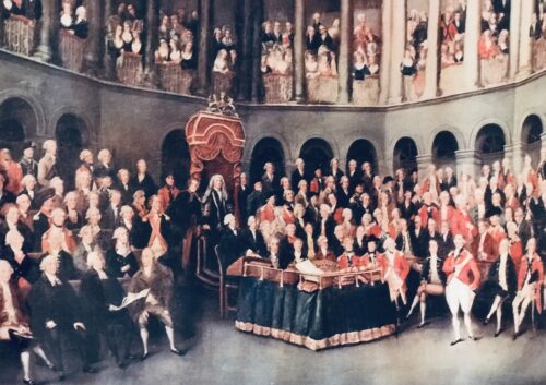
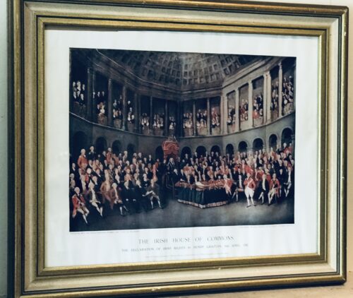
  • 50cm x 60cm  Dublin This rare and historical print depicts Grattans Irish House of Parliament before it fell under the Act of Union in 1800,whereupon Ireland would be governed from London for the next 120 years.This parliament was loyal to the King and was essentially an assembly of the leading members of the landed gentry of the country,loyal to the Anglican Church of Ireland who owned most of the land.The politicians of the national party now fought for the Irish parliament, not with the intention of liberating the Catholic majority, but to set the Irish parliament free from constitutional bondage to the British Privy Council. By virtue of Poynings' Law, a statute of King Henry VII of England, all proposed Irish legislation had to be submitted to the Privy Council for its approval under the Great Seal of England before being passed by the Irish parliament. A bill so approved might be accepted or rejected, but not amended. More recent British Acts had further emphasised the complete dependence of the Irish parliament, and the appellate jurisdiction of the Irish House of Lords had also been annulled. Moreover, the British Houses claimed and exercised the power to legislate directly for Ireland without even the nominal concurrence of the parliament in Dublin. This was the constitution which William Molyneux and Swift had denounced, which Flood had attacked, and which Grattan was to destroy, becoming leaders of the Patriot movement.
    The Irish House of Commons by Francis Wheatley (1780) shows Grattan (standing on right in red jacket) addressing the House.
    Calls for the legislative independence of Ireland at the Irish Volunteer Convention at Dungannon greatly influenced the decision of the government in 1782 to make concessions. It was through ranks of Volunteers drawn up outside the parliament house in Dublin that Grattan passed on 16 April 1782, amidst unparalleled popular enthusiasm, to move a declaration of the independence of the Irish parliament. "I found Ireland on her knees," Grattan exclaimed, "I watched over her with a paternal solicitude; I have traced her progress from injuries to arms, and from arms to liberty. Spirit of Swift, spirit of Molyneux, your genius has prevailed! Ireland is now a nation!" After a month of negotiation the claims of Ireland were conceded. The gratitude of his countrymen to Grattan was shown by a parliamentary grant of £100,000, which had to be reduced by half before he would accept it.Grattan then asked for the British House of Commons to reconfirm the London government's decision, and on 22 January 1783 the final Act was passed by parliament in London.However by 1800 under the Act of Union Grattans Parliament would cease to exist. From the perspective of Great Britain, the union was desirable because of the uncertainty that followed the Irish Rebellion of 1798 and the French Revolution of 1789; if Ireland adopted Catholic Emancipation, willingly or not, a Roman Catholic parliament could break away from Britain and ally with the French, while the same measure within a united kingdom would exclude that possibility. Also the Irish and British parliaments, when creating a regency during King George III's "madness", gave the Prince Regent different powers. These considerations led Great Britain to decide to attempt merger of the two kingdoms and their parliaments.The final passage of the Act in the Irish Parliament was achieved with substantial majorities, in part according to contemporary documents through bribery, namely the awarding of peerages and honours to critics to get their votes.Whereas the first attempt had been defeated in the Irish House of Commons by 109 votes against to 104 for, the second vote in 1800 produced a result of 158 to 115. Yet in the heart of every Irishman,whatever his politics or religion ,there is a tender spot for Grattans Parliament and the genius, wit and oratory of its members will live long and be cherished with pride by their countrymen.The present Bank of Ireland at College Green,directly adjacent to Trinity College Dublin,was the site of the old Parliament building ,built in1729   and the worlds first purpose built bi-cameral Parliament House .Architects were Pearce and James Gandon .  
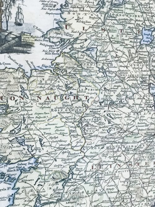
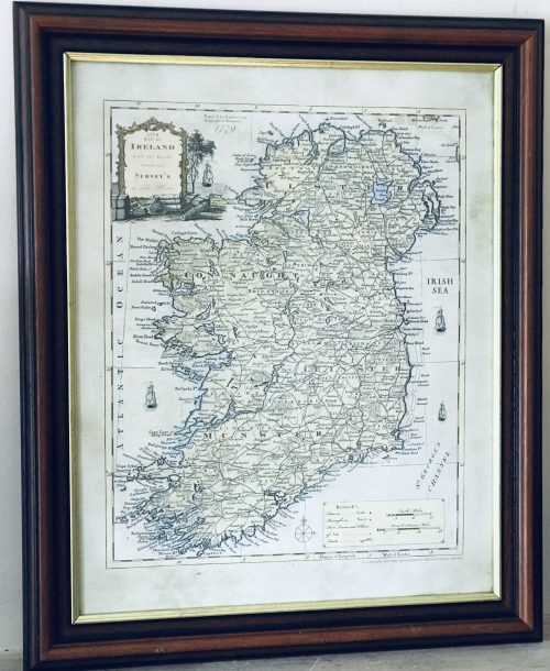
  • Very interesting and superbly framed Map of Ireland from 1779 from the latest surveys of the time. 62cm x 49cm Dublin  
  • 42cm x 48cm  Limerick Fascinating Draught plan of the country around Limerick taken in 1752 by William Eyres Map Maker - the scale is at 320 yards to one inch.
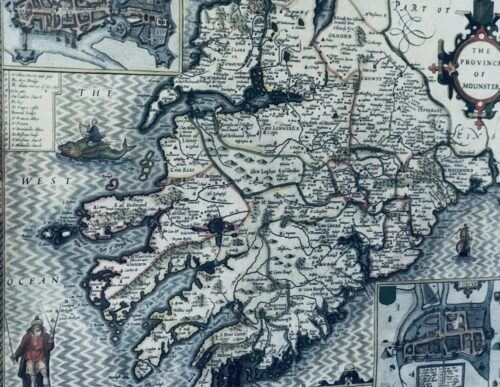
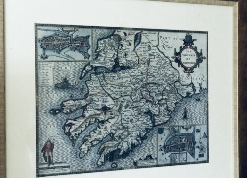
  • Fascinating map from 1610 as by the renowned cartographer John speed of the Province of Mounster(Munster!)-comprising the counties of Tipperary,Clare,Limerick,Cork,Kerry & Waterford.Includes miniature city layouts of both Limerick & Cork. 52cm x 65cm   Beaufort Co Kerry John Speed (1551 or 1552 – 28 July 1629) was an English cartographer and historian. He is, alongside Christopher Saxton, one of the best known English mapmakers of the early modern period.

    Life

    Speed was born in the Cheshire village of Farndon and went into his father Samuel Speed's tailoring later in life. While working in London, Speed was a tailor and member of a corresponding guild, and came to the attention of "learned" individuals. These individuals included Sir Fulke Greville, who subsequently made him an allowance to enable him to devote his whole attention to research. By 1598 he had enough patronage to leave his manual labour job and "engage in full-time scholarship". As a reward for his earlier efforts, Queen Elizabethgranted Speed the use of a room in the Custom House. Speed, was, by this point, as "tailor turned scholar" who had a highly developed "pictorial sense". In 1575, Speed married a woman named Susanna Draper in London, later having children with her. These children definitely included a son named John Speed, later a "learned" man with a doctorate, and an unknown number of others, since chroniclers and historians cannot agree on how many children they raised. Regardless, there is no doubt that the Speed family was relatively well-off. By 1595, Speed published a map of biblical Canaan, in 1598 he presented his maps to Queen Elizabeth, and in 1611–1612 he published maps of Great Britain, with his son perhaps assisting Speed in surveys of English towns. At age 77 or 78, in August 1629, Speed died. He was buried alongside his wife in London's St Giles-without-Cripplegate church on Fore Street. Later on, a memorial to John Speed was also erected behind the altar of the church.According to the church's website, "[His was] one of the few memorials [in the church] that survived the bombing" of London during The Blitz of 1940–1941 ... The website also notes that "[t]he cast for the niche in which the bust is placed was provided by the Merchant Taylors' Company, of which John Speed was a member". His memorial brass has ended up on display in the Burrell Collection near Glasgow.

    Works

    Speed drew historical maps in 1601 and 1627 depicting the invasion of England and Ireland, depictions of the English Middle Ages, along with those depicting the current time, with rough originals but appealing, colourful final versions of his maps. It was with the encouragement of William Camden that Speed began his Historie of Great Britaine, which was published in 1611. Although he probably had access to historical sources that are now lost to us (he certainly used the work of Saxton and Norden), his work as a historian is now considered secondary in importance to his map-making, of which his most important contribution is probably his town plans, many of which provide the first visual record of the British towns they depict.In the years leading up to this point, while his atlas was being compiled, he sent letters to Robert Cotton, part of the British government to ask for assistance in gathering necessary materials.
    In 1627 George Humble published the Prospect of the Most Famous Parts of the World, printed by John Dawson. This is the world map from this atlas with John Speed's name in the title, but not attributed to Speed's authorship.
    His atlas The Theatre of the Empire of Great Britaine was published in 1611 and 1612, and contained the first set of individual county maps of England and Wales besides maps of Ireland and a general map of Scotland. Tacked onto these maps was an introduction at the beginning when he addressed his "well affected and favourable reader", which had numerous Christian and religious undertones, admitting that there may be errors, but he made it the best he could, and stated his purpose for the atlas:
    my purpose...is to shew the situation of every Citie and Shire-town only [within Great Britain]...I have separated...[with] help of the tables...any Citie, Towne, Borough, Hamlet, or Place of Note...[it] may be affirmed, that there is not any one Kingdome in the world so exactly described...as is...Great Britaine...In shewing these things, I have chiefly sought to give satisfaction to all.
    With maps as "proof impressions" and printed from copper plates, detail was engraved in reverse with writing having to be put on the map the correct way, while speed "copied, adapted and compiled the work of others", not doing much of the survey work on his own, which he acknowledged.The atlas was not above projections of his political opinions" Speed represented King James I as one who unified the "Kingdoms of the British isles". In 2016, the British Library published a book, introduced by former MP Nigel Nicolson and accompanied by commentaries by late medieval and early modern historian Alasdair Hawkyard, which reprinted this collection of maps on the British Isles, showing that Speed had drawn maps of areas ranging from Bedfordshire to Norfolk and Wales. Most, but not all, of the county maps have town plans on them; those showing a Scale of Passes being the places he had mapped himself. In 1627, two years before his death, Speed published Prospect of the Most Famous Parts of the World which was the first world atlas produced by an Englishman, costing 40 shillings, meaning that its circulation was limited to "richer customers and libraries", where many survive to this day. There is a fascinating text describing the areas shown on the back of the maps in English, although a rare edition of 1616 of the British maps has a Latin text – this is believed to have been produced for the Continental market. Much of the engraving was done in Amsterdam at the workshop of a Flemish man named Jodocus Hondius, with whom he collaborated with from 1598 until 1612, with Hondius's sudden death, a time period of 14 years.His maps of English and Welsh counties, often bordered with costumed figures ranging from nobility to country folk, are often found framed in homes throughout the United Kingdom. In 1611, he also published The genealogies recorded in the Sacred Scriptures according to euery family and tribe with the line of Our Sauior Jesus Christ obserued from Adam to the Blessed Virgin Mary, a biblical genealogy, reprinted several times during the 17th century. He also drew maps of the Channel Islands, Poland, and the Americas, the latter published only a few years before his death. On the year of his death, yet another collection of maps of Great Britain he had drawn the year before were published. Described as a "Protestant historian", "Puritan historian" or "Protestant propagandist" by some, Speed wrote about William Shakespeare, whom he called a "Superlative Monster" because of certain plays, Roman conquest, history of Chester, and explored "early modern concepts of national identity". As these writings indicate, he possibly saw Wales as English and not an independent entity. More concretely, there is evidence that Speed, in his chronicling of history, uses "theatrical metaphors" and his developed "historiographic skill" to work while he repeats myths from medieval times as part of his story.

    Legacy

    Since his maps were used in many high circles, Speed's legacy has been long-reaching. After his death, in 1673 and 1676, some of his other maps on the British isles, the Chesapeake Bay region, specifically of Virginia and Maryland, the East Indies, the Russian Empire then ruled by Peter the Great, Jamaica, and Barbados, among other locations.With these printings and others, Speed's maps became the basis for world maps until at least the mid-eighteenth century, with his maps reprinted many times, and served as a major contribution to British topography for years to come. In later years, Speed would be called "our English Mercator", a person of "extraordinary industry and attainments in the study of antiques", an "honest and impartial historian", a "faithful Chronologer", and "our Cheshire historian...a scholar...a distinguished writer on history".He was also called a "celebrated chronologer and histographer", "cartographer", and much more. Even today, prints of his "beautiful maps" can be found in living rooms across the world, and sell for hundreds of thousands of pounds in rare art and map auctions, drawing in map collectors across the globe.Additionally, some use John Speed's maps, and connected commentary, to interpret William Shakespeare's plays; however, Speed did not like Shakespeare in the slightest, and called him a "papist".
  • 34cm x 22cm
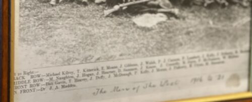
    This Flying Column operated across the West Mayo area during the War of Independence. The photograph was taken shortly after the Carrowkennedy ambush on a RIC Barracks; the men are displaying the captured weapons. On the 2nd June 1921 the West Mayo Flying Column ambushed British soldiers on the Westport to Leenane road. After the ambush they went on the run. While near Laherdane in the vicinity of Neiphin Mountain they were visited by Jack Leonard. Leonard was a photographer and a cousin of Michael Kilroy, who was the Officer in Command of the brigade and took the only photograph of the Flying Column that exists.

     
Go to Top