-
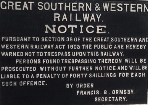
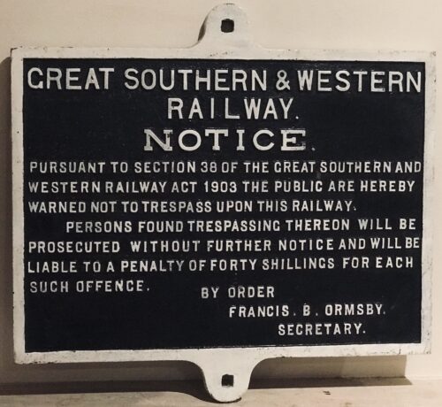 46cm x 48cm Cork Excellent original example of an original Great Southern & Western Railway sign warning the public against trespassing, otherwise finding themselves liable to the sizeable penalty of 40 shillings,By order of Francis B Ormsby.The Great Southern & Western Railway was an Irish gauge railway company founded in 1844 until it was wound up in the Free State that existed ins 1924.It became the largest of Irelands Big 4 railway networks and at its peak it had an 1100 mile network, of which 240 miles were double track.The most heavily used existing routes of today ,linking Dublin with Cork,Limerick and Waterford are all old GS&WR routes and the coats of arms of these cities adorn the facade of Hueston Station Dublin,formerly Kingsbridge Station until it was renamed in 1966.
 -
 Stunning original oil painting depicting two iconic Limerick landmarks,King Johns Castle & The Treaty Stone.The artists signature is difficult to decipher but this is still an exquisite piece of art. 56cm x 50cm Clarenbridge Co Galway King John's Castle (Irish: Caisleán Luimnigh) is a 13th-century castle located on King's Island in Limerick, Ireland, next to the River Shannon.Although the site dates back to 922 when the Vikings lived on the Island, the castle itself was built on the orders of King John in 1200. One of the best preserved Norman castles in Europe, the walls, towers and fortifications remain today and are visitor attractions. The remains of a Viking settlement were uncovered during archaeological excavations at the site in 1900.The Treaty Stone is the rock that the Treaty of Limerick was signed in 1691, marking the surrender of the city to William of Orange.Limerick is known as the Treaty City, so called after the Treaty of Limerick signed on the 3rd of October 1691 after the war between William III of England (known as William of Orange) and his Father in Law King James II. Limericks role in the successful accession of William of Orange and his wife Mary Stuart, daughter of King James II to the throne of England cannot be understated. The Treaty, according to tradition was signed on a stone in the sight of both armies at the Clare end of Thomond Bridge on the 3rd of October 1691. The stone was for some years resting on the ground opposite its present location, where the old Ennis mail coach left to travel from the Clare end of Thomond Bridge, through Cratloe woods en route to Ennis. The Treaty stone of Limerick has rested on a plinth since 1865, at the Clare end of Thomond Bridge. The pedestal was erected in May 1865 by John Richard Tinsley, mayor of the city.
 -
 61cm x 69cm
An absolute once off piece of Irish Memorabilia .We at the Irish Pub Emporium were so lucky to acquire from a private collector who has moved overseas.These superb castiron road signs were commissioned by the Irish Free State in the late 1940s post and were initially the responsibility of the newly formed Irish Tourism Organisation -Fógra Failte (later to become Bord Failte and then Failte Ireland).
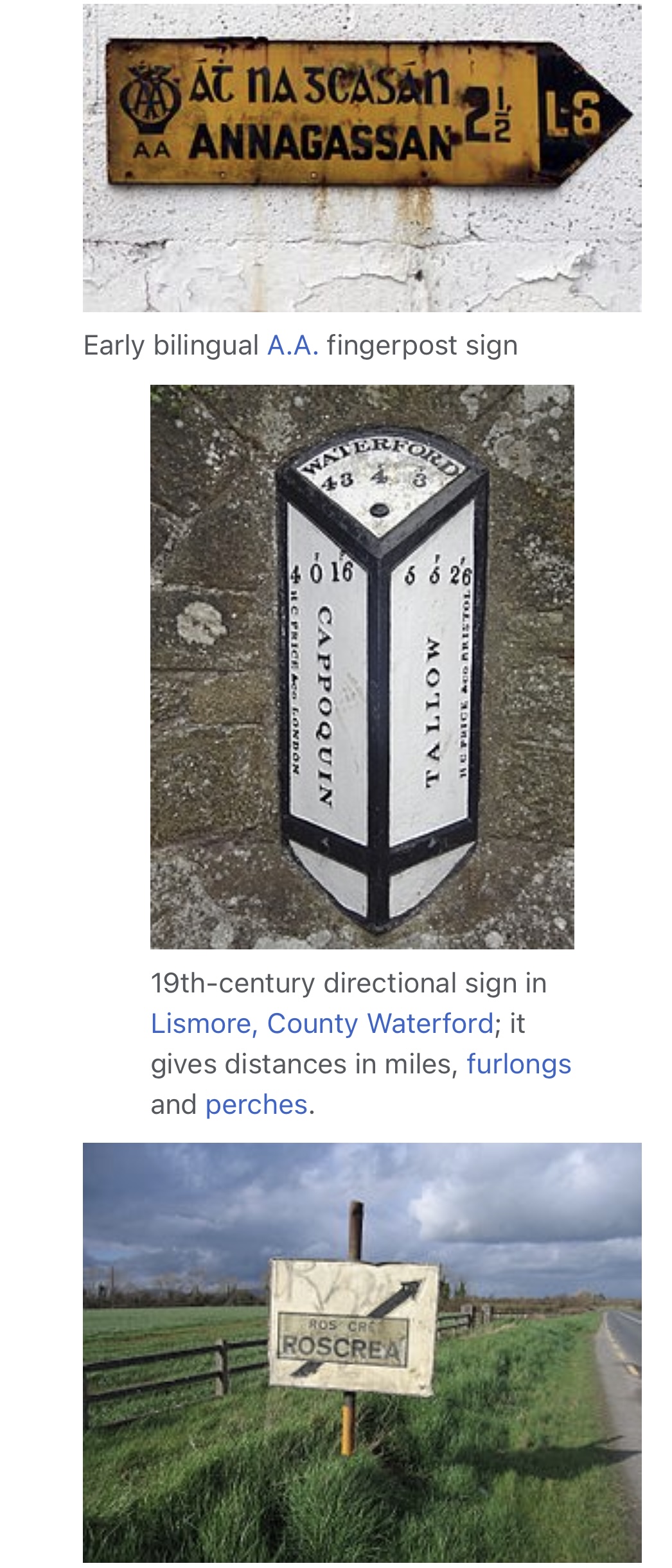
"The former 'fingerpost' style of Irish directional signs can still be seen in many rural areas of the Republic of Ireland. These signs differ from their modern-day equivalent as they have black raised text on a white background. Destinations are in all caps (the placename in Irish was on top and in a smaller font than the one in English). Sometimes, the former route number ("T" for trunk road, "L" for link road) can be seen, and the former Bord Fáilte logo can be seen on some (they had responsibility for signs for a time), as well as occasionally a harp. Distances on these signs are in miles.
This style of sign has become a common feature of many tourist images of Ireland and can be seen in some Irish pubs. However, they can be easily rotated, and have been done so on occasion and therefore are not completely reliable. While most examples of these signs still in situ are rural finger-posts, the advance directional sign of this era can still very occasionally be seen: this has a grey background, with the destinations in outlined, white-background boxes linked together with black lines, and the text is not raised on these, unlike on fingerposts. These signs, rare even when the system was in use, can be seen in some areas of Dún Laoghaire and Drogheda. These signs were prescribed under various regulations, with the final design prescribed under the Road Traffic Signs (Regulations) 1962.
Despite the new sign style being introduced in 1977, the design change was never legislated for (apart from a reference to the change to italics in 1989) and the old designs were repealed only under the 1997 regulations, 20 years later.
61cm x 69cm
An absolute once off piece of Irish Memorabilia .We at the Irish Pub Emporium were so lucky to acquire from a private collector who has moved overseas.These superb castiron road signs were commissioned by the Irish Free State in the late 1940s post and were initially the responsibility of the newly formed Irish Tourism Organisation -Fógra Failte (later to become Bord Failte and then Failte Ireland).
"The former 'fingerpost' style of Irish directional signs can still be seen in many rural areas of the Republic of Ireland. These signs differ from their modern-day equivalent as they have black raised text on a white background. Destinations are in all caps (the placename in Irish was on top and in a smaller font than the one in English). Sometimes, the former route number ("T" for trunk road, "L" for link road) can be seen, and the former Bord Fáilte logo can be seen on some (they had responsibility for signs for a time), as well as occasionally a harp. Distances on these signs are in miles.
This style of sign has become a common feature of many tourist images of Ireland and can be seen in some Irish pubs. However, they can be easily rotated, and have been done so on occasion and therefore are not completely reliable. While most examples of these signs still in situ are rural finger-posts, the advance directional sign of this era can still very occasionally be seen: this has a grey background, with the destinations in outlined, white-background boxes linked together with black lines, and the text is not raised on these, unlike on fingerposts. These signs, rare even when the system was in use, can be seen in some areas of Dún Laoghaire and Drogheda. These signs were prescribed under various regulations, with the final design prescribed under the Road Traffic Signs (Regulations) 1962.
Despite the new sign style being introduced in 1977, the design change was never legislated for (apart from a reference to the change to italics in 1989) and the old designs were repealed only under the 1997 regulations, 20 years later. -
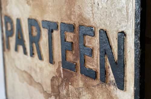
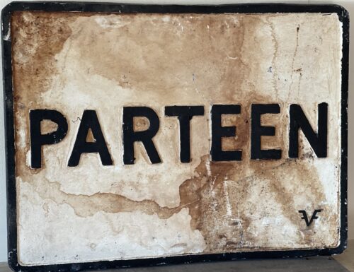 62cm x 45cm
An absolute once off piece of Irish Memorabilia .We at the Irish Pub Emporium were so lucky to acquire from a private collector .These superb castiron road signs were commissioned by the Irish Free State in the late 1940s post and were initially the responsibility of the newly formed Irish Tourism Organisation -Fógra Failte (later to become Bord Failte and then Failte Ireland).
"The former 'fingerpost' style of Irish directional signs can still be seen in many rural areas of the Republic of Ireland. These signs differ from their modern-day equivalent as they have black raised text on a white background. Destinations are in all caps (the placename in Irish was on top and in a smaller font than the one in English). Sometimes, the former route number ("T" for trunk road, "L" for link road) can be seen, and the former Bord Fáilte logo can be seen on some (they had responsibility for signs for a time), as well as occasionally a harp. Distances on these signs are in miles.
This style of sign has become a common feature of many tourist images of Ireland and can be seen in some Irish pubs. However, they can be easily rotated, and have been done so on occasion and therefore are not completely reliable. While most examples of these signs still in situ are rural finger-posts, the advance directional sign of this era can still very occasionally be seen: this has a grey background, with the destinations in outlined, white-background boxes linked together with black lines, and the text is not raised on these, unlike on fingerposts. These signs, rare even when the system was in use, can be seen in some areas of Dún Laoghaire and Drogheda. These signs were prescribed under various regulations, with the final design prescribed under the Road Traffic Signs (Regulations) 1962.
Despite the new sign style being introduced in 1977, the design change was never legislated for (apart from a reference to the change to italics in 1989) and the old designs were repealed only under the 1997 regulations, 20 years later.
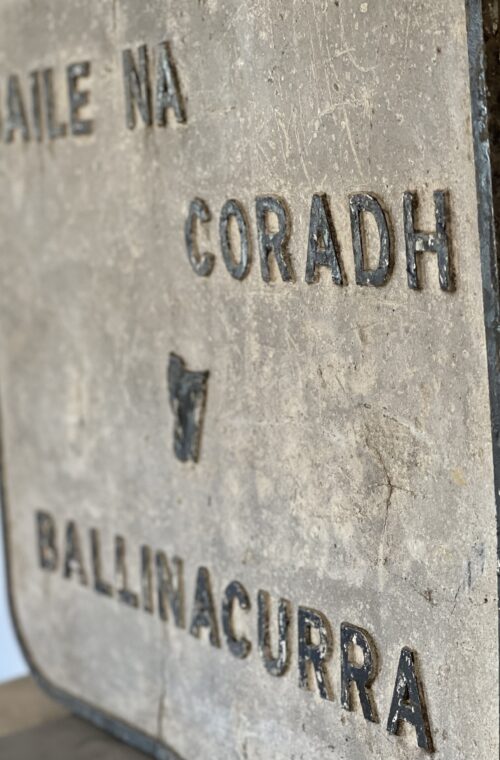
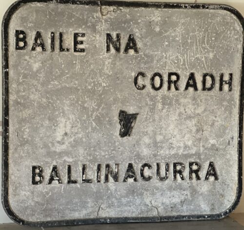
62cm x 45cm
An absolute once off piece of Irish Memorabilia .We at the Irish Pub Emporium were so lucky to acquire from a private collector .These superb castiron road signs were commissioned by the Irish Free State in the late 1940s post and were initially the responsibility of the newly formed Irish Tourism Organisation -Fógra Failte (later to become Bord Failte and then Failte Ireland).
"The former 'fingerpost' style of Irish directional signs can still be seen in many rural areas of the Republic of Ireland. These signs differ from their modern-day equivalent as they have black raised text on a white background. Destinations are in all caps (the placename in Irish was on top and in a smaller font than the one in English). Sometimes, the former route number ("T" for trunk road, "L" for link road) can be seen, and the former Bord Fáilte logo can be seen on some (they had responsibility for signs for a time), as well as occasionally a harp. Distances on these signs are in miles.
This style of sign has become a common feature of many tourist images of Ireland and can be seen in some Irish pubs. However, they can be easily rotated, and have been done so on occasion and therefore are not completely reliable. While most examples of these signs still in situ are rural finger-posts, the advance directional sign of this era can still very occasionally be seen: this has a grey background, with the destinations in outlined, white-background boxes linked together with black lines, and the text is not raised on these, unlike on fingerposts. These signs, rare even when the system was in use, can be seen in some areas of Dún Laoghaire and Drogheda. These signs were prescribed under various regulations, with the final design prescribed under the Road Traffic Signs (Regulations) 1962.
Despite the new sign style being introduced in 1977, the design change was never legislated for (apart from a reference to the change to italics in 1989) and the old designs were repealed only under the 1997 regulations, 20 years later. -

 62cm x 62cm approx A real rarity here in the octagonal shape of a vintage Ireland Inland Waterways Cast-iron Sign denoting the river Shannon & Limerick.This most unusual find has been carefully restored and repainted and will make a most suitable exhibit for the most discerning Irish bar with Limerick /River Shannon affiliations.Please contact us directly at irishpubemporium@gmail.com or at 00353 878393200 to discuss.