-
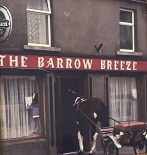
 27cm x 27cm The Barrow Breeze is a pub in the capital of the Irish Sporthorse business-Goresbridge Co Kilkenny. Goresbridge (Irish: An Droichead Nua, meaning 'The New Bridge') is a small village located in the east of County Kilkenny, in the province of Leinster, Ireland. Goresbridge is named after a 1756 bridge, built by Colonel Ralph Gore, which provides a crossing of the River Barrow between County Kilkenny and County Carlow in the South-East region. Located 2.75 miles (4.43 km) from Gowran on the R702 (Kilkenny−Enniscorthy) regional road, and approximately 20 kilometres (12 mi) east of Kilkenny. Part of the civil parish is Grangesilvia which is in the barony of Gowran. King Charles II granted Arthur Gore the townland of Barrowmount. The "Battle of Goresbridge" occurred there in June 1798. The 2011 census the population of the census town was 361. The local authority is Kilkenny County Council. Goresbridge gives its name to a district electoral division Goresbridge was located in historic Gaelic kingdom of Ossory (Osraige). Following the Williamite–Jacobite War King Charles II gave grants of land which had been forfeited by the Roman Catholic owners. Arthur Gore obtained a grant of land, the townland of Barrowmount in parish of Grangesilvia, from Charles II,and by the end of the 17th century the Gore family were well established. "Goresbridge" was named for the family and the New Bridge built in 1756 by Colonel Ralph Gore. On the 1846 OSI map of Ireland the village is referred to it as Newbridge.
 -
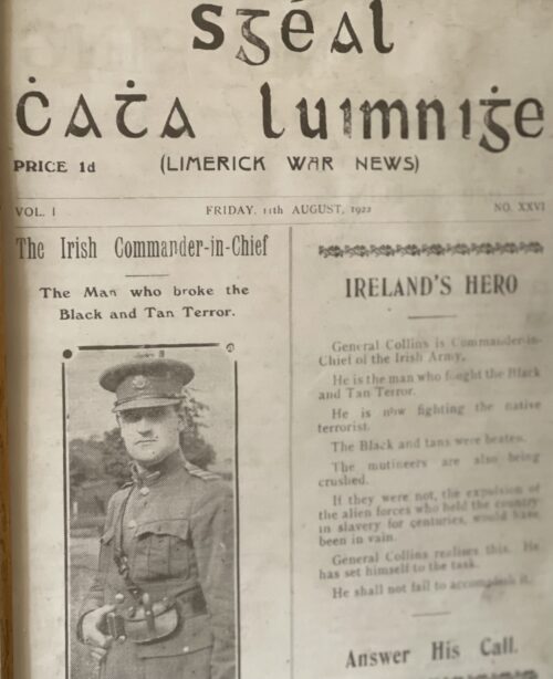
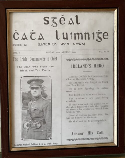 30cm x 25cm Cork Michael Collins was a revolutionary, soldier and politician who was a leading figure in the early-20th-century Irish struggle for independence. He was Chairman of the Provisional Government of the Irish Free State from January 1922 until his assassination in August 1922. Collins was born in Woodfield, County Cork, the youngest of eight children, and his family had republican connections reaching back to the 1798 rebellion. He moved to London in 1906, to become a clerk in the Post Office Savings Bank at Blythe House. He was a member of the London GAA, through which he became associated with the Irish Republican Brotherhood and the Gaelic League. He returned to Ireland in 1916 and fought in the Easter Rising. He was subsequently imprisoned in the Frongoch internment camp as a prisoner of war, but was released in December 1916. Collins rose through the ranks of the Irish Volunteers and Sinn Féin after his release from Frongoch. He became a Teachta Dála for South Cork in 1918, and was appointed Minister for Finance in the First Dáil. He was present when the Dáil convened on 21 January 1919 and declared the independence of the Irish Republic. In the ensuing War of Independence, he was Director of Organisation and Adjutant General for the Irish Volunteers, and Director of Intelligence of the Irish Republican Army. He gained fame as a guerrilla warfare strategist, planning and directing many successful attacks on British forces, such as the assassination of key British intelligence agents in November 1920. After the July 1921 ceasefire, Collins and Arthur Griffith were sent to London by Éamon de Valera to negotiate peace terms. The resulting Anglo-Irish Treaty established the Irish Free State but depended on an Oath of Allegiance to the Crown, a condition that de Valera and other republican leaders could not reconcile with. Collins viewed the Treaty as offering "the freedom to achieve freedom", and persuaded a majority in the Dáil to ratify the Treaty. A provisional government was formed under his chairmanship in early 1922 but was soon disrupted by the Irish Civil War, in which Collins was commander-in-chief of the National Army. He was shot and killed in an ambush by anti-Treaty on 22nd August 1922.
 -
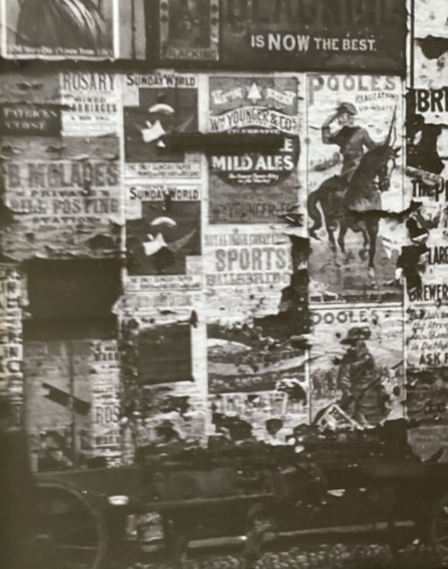
 Fascinating vintage photograph of a Dublin City Centre Wall totally given over to yesteryear advertising posters.A horse and cart can be seen adjacent .Some of the products and companies being advertised include institutions long closed including-Manders Dublin Ale,Phoenix Brewery,Cooneys Blackening,Pooles, Also posters advertising a sports day in Ballsbridge and rosaries for mixed marriages ! Robert Manders & Co, New Brewery, 113 James Street, Dublin, Ireland. Established 1800 and registered in 1882. Association with the Phoenix Brewery (Dublin) Ltd. was terminated in 1897 and carried on though restricted to ale brewing until c.1907. From:-The Breweries and Distilleries in Dublin In 1862 Robert Manders & Co brewery occupied 111-113 at the north side of James Street. The concern was also the business address of the Manders family. Alfred of Flesk Priory, Killarney, Frederick of Belfield, Roebuck, Richard of Brackenstown, Swords, Robert of Landscape, Dundrum, Herbert of Obelisk Park, Blackrock, Richard of Shanganagh, Bray, and Robert Geoghegan of Carysfort, Stillorgan. Apart from the brewery they had flour mills at Islandbridge and bakeries at Fownes Street, Moore Street, Church Street, Camden Street, and Baggot Street. The brewery continued until 1909. Phoenix Brewery (Dublin) Ltd, 89 James's Street, Dublin, Ireland. Founded 1778 and was later known as the Phoenix Porter Brewery Co. Registered January 1897. Acquired by John D'Arcy & Son Ltd 1906 and closed 1909. From the Brewery History society Journal Number 91 This brewery publicly advertised itself as "the largest brewery in Ireland but one". Founded in 1788 by Charles Madder who by all accounts was a brilliant technical and innovative brewer. He had come from London to brew porter in Dublin. His business and trading activities were poor and the brewery was rescued by one John Brennan and later his son Charles. Essentially a porter brewery with a capacity to produce 350,000 bulk barrels per annum, it launched its own O'Connell's Dublin Ale. This was probably due to the fact that when they took over Robert Manders & Co's Brewery, their next door neighbours in 1897 it replaced Mander's Dublin Ale. It enjoyed a local and export trade however for whatever the reasons it became bankrupt and closed in 1909. The franchise of brewing O'Connell's Dublin Ale was given to D'Arcys. From:- Breweries and Distilleries in Dublin Francis Coleman moved from 103 to 105 James Street on 15-8-1807. At that time Francis Coleman & Hamilton dissolved their brewing partnership. The Guinness Power station site (now Roe & Co distillery) near the corner of Watling Street occupied part of the site of the Phoenix brewery founded in 1778 by an English brewer called Mather. In 1828 John Brennan bought the brewery and was succeeded by Charles Brenan. Daniel O’Connell junior son of the Liberator acquired the Phoenix Brewery in 1831 which occupies a three acre site at the corner of Watling Street and James’s Street. It operated under the name O’Connell’s brewery for a time. There was a campaign to support their porter as “Catholic” against Guinnness’s “protestant porter“. Daniel O’Connell, the Liberator, refused to support that activity while he was an MP. Guinness was a political rival but was quite liberal on the Catholic Emancipation and Repeal questions. Phoenix acquired the adjoining the six acre Manders brewery site at 111-117 James’s Street and in 1897 the concern became a public company. The brewery extended from James Street to the Quays and had the second largest output in Ireland. John D'Arcy & Son Ltd’s Anchor Brewery bought the Phoenix brewery, then operating for 160 years on 13-6-1905 and it was hoped to continue both breweries as well as the Phoenix brand O’Connell’s ale. However by 13-10-1905 the Phoenix site was for auction. Cooneys Blacking in Penny Boxes: Blacking (polish), a nineteenth-century shoe polish Younger's Brewery (William Younger & Company) was a brewery in Edinburgh which grew from humble beginnings in 1749 to become one of the city’s main commercial enterprises, supplying domestic and foreign markets. It should not be confused with another, less renowned Edinburgh brewery, that of Robert Younger, who also brewed in Holyrood at the St. Ann's Brewery or that of George Younger, who brewed in Alloa. In 1931 Younger's merged with McEwan’s to form Scottish Brewers, which in turn merged with Newcastle Breweries in 1960 to form Scottish & Newcastle. By the late 1960s the combine employed the largest single workforce in the city
 -
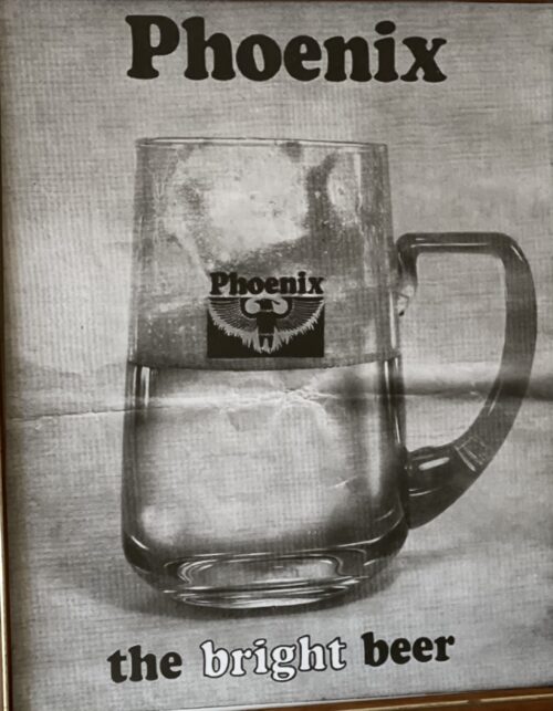
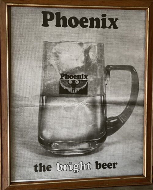 40cm x 35cm Phoenix Brewery (Dublin) Ltd, 89 James's Street, Dublin, Ireland. Founded 1778 and was later known as the Phoenix Porter Brewery Co. Registered January 1897. Acquired by John D'Arcy & Son Ltd 1906 and closed 1909. This brewery publicly advertised itself as "the largest brewery in Ireland but one". Founded in 1788 by Charles Madder who by all accounts was a brilliant technical and innovative brewer. He had come from London to brew porter in Dublin. His business and trading activities were poor and the brewery was rescued by one John Brennan and later his son Charles. Essentially a porter brewery with a capacity to produce 350,000 bulk barrels per annum, it launched its own O'Connell's Dublin Ale. This was probably due to the fact that when they took over Robert Manders & Co's Brewery, their next door neighbours in 1897 it replaced Mander's Dublin Ale. It enjoyed a local and export trade however for whatever the reasons it became bankrupt and closed in 1909. The franchise of brewing O'Connell's Dublin Ale was given to D'Arcys. From:- Breweries and Distilleries in Dublin Francis Coleman moved from 103 to 105 James Street on 15-8-1807. At that time Francis Coleman & Hamilton dissolved their brewing partnership. The Guinness Power station site (now Roe & Co distillery) near the corner of Watling Street occupied part of the site of the Phoenix brewery founded in 1778 by an English brewer called Mather. In 1828 John Brennan bought the brewery and was succeeded by Charles Brenan. Daniel O’Connell junior son of the Liberator acquired the Phoenix Brewery in 1831 which occupies a three acre site at the corner of Watling Street and James’s Street. It operated under the name O’Connell’s brewery for a time. There was a campaign to support their porter as “Catholic” against Guinnness’s “protestant porter“. Daniel O’Connell, the Liberator, refused to support that activity while he was an MP. Guinness was a political rival but was quite liberal on the Catholic Emancipation and Repeal questions. Phoenix acquired the adjoining the six acre Manders brewery site at 111-117 James’s Street and in 1897 the concern became a public company. The brewery extended from James Street to the Quays and had the second largest output in Ireland. John D'Arcy & Son Ltd’s Anchor Brewery bought the Phoenix brewery, then operating for 160 years on 13-6-1905 and it was hoped to continue both breweries as well as the Phoenix brand O’Connell’s ale. However by 13-10-1905 the Phoenix site was for auction.
 -
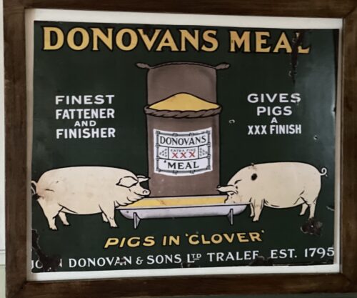 45cm x 35cm I got this piece of interesting information from ‘The Unquiet Grave‘, The Development of Kerry’s Burial Grounds through the Ages – that very interesting book edited by Michael Connolly for Kerry County Council. The chapter on A Tale of Two Tombs tells the fascinating story of the rise and fall of the Donovan family of Tralee, who were wealthy merchants in the town through three generations in 1800’s. Some of you will remember that the Donovans also owned the Jeanie Johnston, which was the Donovan’s most important ship carrying emigrants on the outward journey to Quebec and bringing cargoes of timber back on the return voyage. John Donovan was the founding father and set up a hardware business initially in the Square, Tralee and then branched out leasing and owning shipping bringing iron, coal and slate to Tralee. His sons Nicholas and Henry followed him, they also became the leading political as well as the leading merchants in the town. There is a brilliant description of John’s funeral . He died in 1864 when he was 82 and we are told ‘All the stops were pulled out for the full pageantry of Victorian obsequies’. The Kerry Evening Post reported ‘an unusual grief had fallen upon the town’. According to the same newspaper there were 174 carriages, and there was an important extra little detail -‘the majority were drawn by two horses’ – a two-horse carriage indicated greater social standing than a one-horse carriage’ Try and get hold of this very interesting book from the County Council or log on here for the digital version.And were there any women there at all? Yes, but they were there with a purpose – to provide the all important keening that was then the expected norm at all funerals of all classes. At this funeral we are told ‘The poor of the town, beneficiaries of John Donovan’s generosity, congregated outside the house in The Square, and when the coffin was removed to the hearse, they set up an immense keening, which they continued as they followed the funeral all the way to Ballyseedy’. Another interesting fact relating to women and their own funerals at this time was that ‘while men were buried in the middle of the day, the women, on the other hand were buried early in the morning, regardless of the time of year’. John Donovan’s own wife Catherine was buried in the dark at 6am on a February morning and Nicholas’ wife was buried at the same time in December 1878. ‘Only Henry’s wife was buried in daylight and that was because the burial was at 8am on an August morning in 1885. The higher status of men was constantly affirmed. We have come a long way!
Woman Keening
-
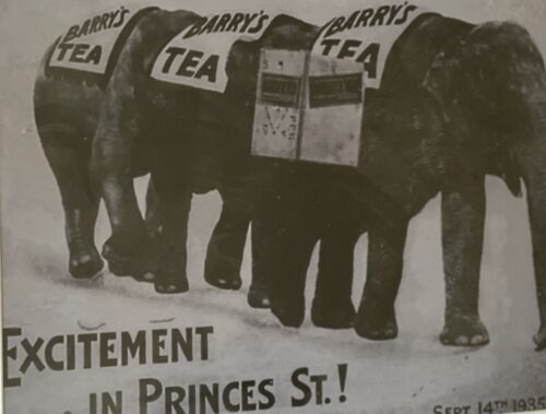
 47cm x 35cm Barry's Tea is an Irish tea company founded in 1901 by James J. Barry in Cork. Until the 1960s, tea was sold from a shop in Prince's Street, but thereafter the company expanded its wholesaling and distribution operations. By the mid-1980s Barry's Tea had become a national brand. According to their website, they are currently responsible for 38% of all tea sales in the Irish market (which is worth an estimated €85 million annually). Today, Barry's Tea is also available in the United Kingdom, Spain, and in some areas of Canada, Australia, France, Luxembourg and the United States where there are significant Irish immigrant communities. Members of the Barry family been elected representatives for Fine Gael: the founder's son Anthony Barry (TD 1954–57 and 1961–65), Anthony's son Peter Barry (TD 1969–97) and Peter's daughter Deirdre Clune (TD 1997–2001 and 2007–11, and MEP since 2014).
 -

 61cm x 69cm
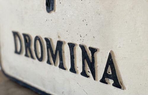
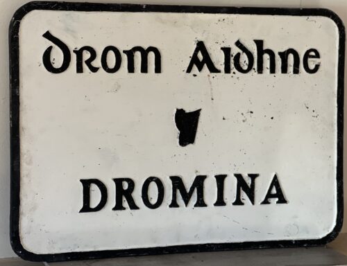
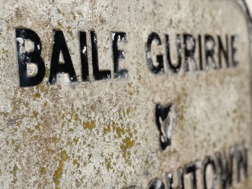
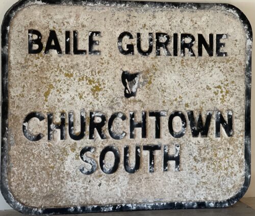
An absolute once off piece of Irish Memorabilia .We at the Irish Pub Emporium were so lucky to acquire from a private collector who has moved overseas.These superb castiron road signs were commissioned by the Irish Free State in the late 1940s post and were initially the responsibility of the newly formed Irish Tourism Organisation -Fógra Failte (later to become Bord Failte and then Failte Ireland).
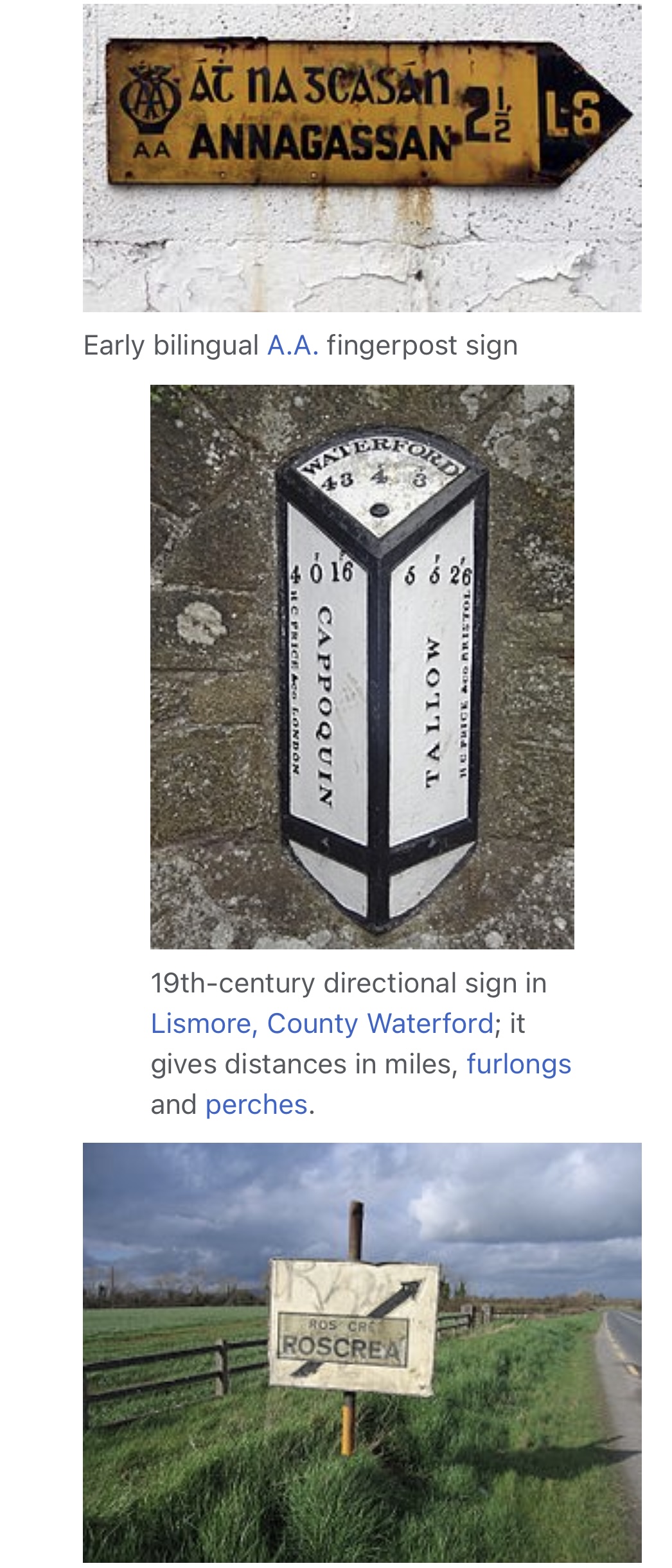
"The former 'fingerpost' style of Irish directional signs can still be seen in many rural areas of the Republic of Ireland. These signs differ from their modern-day equivalent as they have black raised text on a white background. Destinations are in all caps (the placename in Irish was on top and in a smaller font than the one in English). Sometimes, the former route number ("T" for trunk road, "L" for link road) can be seen, and the former Bord Fáilte logo can be seen on some (they had responsibility for signs for a time), as well as occasionally a harp. Distances on these signs are in miles.
This style of sign has become a common feature of many tourist images of Ireland and can be seen in some Irish pubs. However, they can be easily rotated, and have been done so on occasion and therefore are not completely reliable. While most examples of these signs still in situ are rural finger-posts, the advance directional sign of this era can still very occasionally be seen: this has a grey background, with the destinations in outlined, white-background boxes linked together with black lines, and the text is not raised on these, unlike on fingerposts. These signs, rare even when the system was in use, can be seen in some areas of Dún Laoghaire and Drogheda. These signs were prescribed under various regulations, with the final design prescribed under the Road Traffic Signs (Regulations) 1962.
Despite the new sign style being introduced in 1977, the design change was never legislated for (apart from a reference to the change to italics in 1989) and the old designs were repealed only under the 1997 regulations, 20 years later.
61cm x 69cm
An absolute once off piece of Irish Memorabilia .We at the Irish Pub Emporium were so lucky to acquire from a private collector who has moved overseas.These superb castiron road signs were commissioned by the Irish Free State in the late 1940s post and were initially the responsibility of the newly formed Irish Tourism Organisation -Fógra Failte (later to become Bord Failte and then Failte Ireland).
"The former 'fingerpost' style of Irish directional signs can still be seen in many rural areas of the Republic of Ireland. These signs differ from their modern-day equivalent as they have black raised text on a white background. Destinations are in all caps (the placename in Irish was on top and in a smaller font than the one in English). Sometimes, the former route number ("T" for trunk road, "L" for link road) can be seen, and the former Bord Fáilte logo can be seen on some (they had responsibility for signs for a time), as well as occasionally a harp. Distances on these signs are in miles.
This style of sign has become a common feature of many tourist images of Ireland and can be seen in some Irish pubs. However, they can be easily rotated, and have been done so on occasion and therefore are not completely reliable. While most examples of these signs still in situ are rural finger-posts, the advance directional sign of this era can still very occasionally be seen: this has a grey background, with the destinations in outlined, white-background boxes linked together with black lines, and the text is not raised on these, unlike on fingerposts. These signs, rare even when the system was in use, can be seen in some areas of Dún Laoghaire and Drogheda. These signs were prescribed under various regulations, with the final design prescribed under the Road Traffic Signs (Regulations) 1962.
Despite the new sign style being introduced in 1977, the design change was never legislated for (apart from a reference to the change to italics in 1989) and the old designs were repealed only under the 1997 regulations, 20 years later. -
 45cm x 66cm
An absolute once off piece of Irish Memorabilia .We at the Irish Pub Emporium were so lucky to acquire from a private collector who has moved overseas.These superb castiron road signs were commissioned by the Irish Free State in the late 1940s post and were initially the responsibility of the newly formed Irish Tourism Organisation -Fógra Failte (later to become Bord Failte and then Failte Ireland).
"The former 'fingerpost' style of Irish directional signs can still be seen in many rural areas of the Republic of Ireland. These signs differ from their modern-day equivalent as they have black raised text on a white background. Destinations are in all caps (the placename in Irish was on top and in a smaller font than the one in English). Sometimes, the former route number ("T" for trunk road, "L" for link road) can be seen, and the former Bord Fáilte logo can be seen on some (they had responsibility for signs for a time), as well as occasionally a harp. Distances on these signs are in miles.
This style of sign has become a common feature of many tourist images of Ireland and can be seen in some Irish pubs. However, they can be easily rotated, and have been done so on occasion and therefore are not completely reliable. While most examples of these signs still in situ are rural finger-posts, the advance directional sign of this era can still very occasionally be seen: this has a grey background, with the destinations in outlined, white-background boxes linked together with black lines, and the text is not raised on these, unlike on fingerposts. These signs, rare even when the system was in use, can be seen in some areas of Dún Laoghaire and Drogheda. These signs were prescribed under various regulations, with the final design prescribed under the Road Traffic Signs (Regulations) 1962.
Despite the new sign style being introduced in 1977, the design change was never legislated for (apart from a reference to the change to italics in 1989) and the old designs were repealed only under the 1997 regulations, 20 years later.
45cm x 66cm
An absolute once off piece of Irish Memorabilia .We at the Irish Pub Emporium were so lucky to acquire from a private collector who has moved overseas.These superb castiron road signs were commissioned by the Irish Free State in the late 1940s post and were initially the responsibility of the newly formed Irish Tourism Organisation -Fógra Failte (later to become Bord Failte and then Failte Ireland).
"The former 'fingerpost' style of Irish directional signs can still be seen in many rural areas of the Republic of Ireland. These signs differ from their modern-day equivalent as they have black raised text on a white background. Destinations are in all caps (the placename in Irish was on top and in a smaller font than the one in English). Sometimes, the former route number ("T" for trunk road, "L" for link road) can be seen, and the former Bord Fáilte logo can be seen on some (they had responsibility for signs for a time), as well as occasionally a harp. Distances on these signs are in miles.
This style of sign has become a common feature of many tourist images of Ireland and can be seen in some Irish pubs. However, they can be easily rotated, and have been done so on occasion and therefore are not completely reliable. While most examples of these signs still in situ are rural finger-posts, the advance directional sign of this era can still very occasionally be seen: this has a grey background, with the destinations in outlined, white-background boxes linked together with black lines, and the text is not raised on these, unlike on fingerposts. These signs, rare even when the system was in use, can be seen in some areas of Dún Laoghaire and Drogheda. These signs were prescribed under various regulations, with the final design prescribed under the Road Traffic Signs (Regulations) 1962.
Despite the new sign style being introduced in 1977, the design change was never legislated for (apart from a reference to the change to italics in 1989) and the old designs were repealed only under the 1997 regulations, 20 years later. -
 55cm x 68cm
An absolute once off piece of Irish Memorabilia .We at the Irish Pub Emporium were so lucky to acquire from a private collector who has moved overseas.These superb castiron road signs were commissioned by the Irish Free State in the late 1940s post and were initially the responsibility of the newly formed Irish Tourism Organisation -Fógra Failte (later to become Bord Failte and then Failte Ireland).
"The former 'fingerpost' style of Irish directional signs can still be seen in many rural areas of the Republic of Ireland. These signs differ from their modern-day equivalent as they have black raised text on a white background. Destinations are in all caps (the placename in Irish was on top and in a smaller font than the one in English). Sometimes, the former route number ("T" for trunk road, "L" for link road) can be seen, and the former Bord Fáilte logo can be seen on some (they had responsibility for signs for a time), as well as occasionally a harp. Distances on these signs are in miles.
This style of sign has become a common feature of many tourist images of Ireland and can be seen in some Irish pubs. However, they can be easily rotated, and have been done so on occasion and therefore are not completely reliable. While most examples of these signs still in situ are rural finger-posts, the advance directional sign of this era can still very occasionally be seen: this has a grey background, with the destinations in outlined, white-background boxes linked together with black lines, and the text is not raised on these, unlike on fingerposts. These signs, rare even when the system was in use, can be seen in some areas of Dún Laoghaire and Drogheda. These signs were prescribed under various regulations, with the final design prescribed under the Road Traffic Signs (Regulations) 1962.
Despite the new sign style being introduced in 1977, the design change was never legislated for (apart from a reference to the change to italics in 1989) and the old designs were repealed only under the 1997 regulations, 20 years later.
55cm x 68cm
An absolute once off piece of Irish Memorabilia .We at the Irish Pub Emporium were so lucky to acquire from a private collector who has moved overseas.These superb castiron road signs were commissioned by the Irish Free State in the late 1940s post and were initially the responsibility of the newly formed Irish Tourism Organisation -Fógra Failte (later to become Bord Failte and then Failte Ireland).
"The former 'fingerpost' style of Irish directional signs can still be seen in many rural areas of the Republic of Ireland. These signs differ from their modern-day equivalent as they have black raised text on a white background. Destinations are in all caps (the placename in Irish was on top and in a smaller font than the one in English). Sometimes, the former route number ("T" for trunk road, "L" for link road) can be seen, and the former Bord Fáilte logo can be seen on some (they had responsibility for signs for a time), as well as occasionally a harp. Distances on these signs are in miles.
This style of sign has become a common feature of many tourist images of Ireland and can be seen in some Irish pubs. However, they can be easily rotated, and have been done so on occasion and therefore are not completely reliable. While most examples of these signs still in situ are rural finger-posts, the advance directional sign of this era can still very occasionally be seen: this has a grey background, with the destinations in outlined, white-background boxes linked together with black lines, and the text is not raised on these, unlike on fingerposts. These signs, rare even when the system was in use, can be seen in some areas of Dún Laoghaire and Drogheda. These signs were prescribed under various regulations, with the final design prescribed under the Road Traffic Signs (Regulations) 1962.
Despite the new sign style being introduced in 1977, the design change was never legislated for (apart from a reference to the change to italics in 1989) and the old designs were repealed only under the 1997 regulations, 20 years later. -
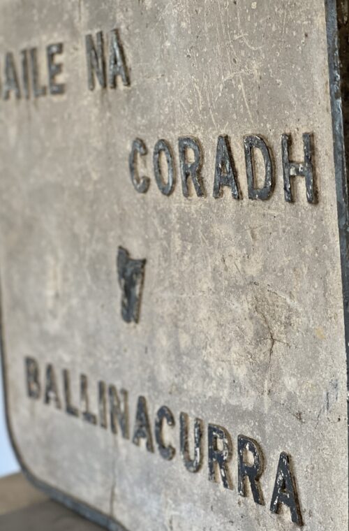
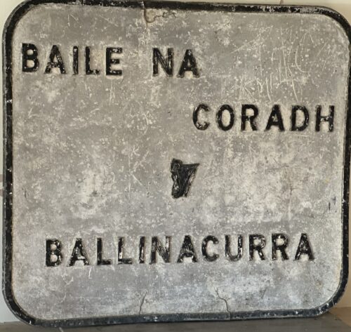 61cm x 69cm
An absolute once off piece of Irish Memorabilia .We at the Irish Pub Emporium were so lucky to acquire from a private collector who has moved overseas.These superb castiron road signs were commissioned by the Irish Free State in the late 1940s post and were initially the responsibility of the newly formed Irish Tourism Organisation -Fógra Failte (later to become Bord Failte and then Failte Ireland).
"The former 'fingerpost' style of Irish directional signs can still be seen in many rural areas of the Republic of Ireland. These signs differ from their modern-day equivalent as they have black raised text on a white background. Destinations are in all caps (the placename in Irish was on top and in a smaller font than the one in English). Sometimes, the former route number ("T" for trunk road, "L" for link road) can be seen, and the former Bord Fáilte logo can be seen on some (they had responsibility for signs for a time), as well as occasionally a harp. Distances on these signs are in miles.
This style of sign has become a common feature of many tourist images of Ireland and can be seen in some Irish pubs. However, they can be easily rotated, and have been done so on occasion and therefore are not completely reliable. While most examples of these signs still in situ are rural finger-posts, the advance directional sign of this era can still very occasionally be seen: this has a grey background, with the destinations in outlined, white-background boxes linked together with black lines, and the text is not raised on these, unlike on fingerposts. These signs, rare even when the system was in use, can be seen in some areas of Dún Laoghaire and Drogheda. These signs were prescribed under various regulations, with the final design prescribed under the Road Traffic Signs (Regulations) 1962.
Despite the new sign style being introduced in 1977, the design change was never legislated for (apart from a reference to the change to italics in 1989) and the old designs were repealed only under the 1997 regulations, 20 years later.
61cm x 69cm
An absolute once off piece of Irish Memorabilia .We at the Irish Pub Emporium were so lucky to acquire from a private collector who has moved overseas.These superb castiron road signs were commissioned by the Irish Free State in the late 1940s post and were initially the responsibility of the newly formed Irish Tourism Organisation -Fógra Failte (later to become Bord Failte and then Failte Ireland).
"The former 'fingerpost' style of Irish directional signs can still be seen in many rural areas of the Republic of Ireland. These signs differ from their modern-day equivalent as they have black raised text on a white background. Destinations are in all caps (the placename in Irish was on top and in a smaller font than the one in English). Sometimes, the former route number ("T" for trunk road, "L" for link road) can be seen, and the former Bord Fáilte logo can be seen on some (they had responsibility for signs for a time), as well as occasionally a harp. Distances on these signs are in miles.
This style of sign has become a common feature of many tourist images of Ireland and can be seen in some Irish pubs. However, they can be easily rotated, and have been done so on occasion and therefore are not completely reliable. While most examples of these signs still in situ are rural finger-posts, the advance directional sign of this era can still very occasionally be seen: this has a grey background, with the destinations in outlined, white-background boxes linked together with black lines, and the text is not raised on these, unlike on fingerposts. These signs, rare even when the system was in use, can be seen in some areas of Dún Laoghaire and Drogheda. These signs were prescribed under various regulations, with the final design prescribed under the Road Traffic Signs (Regulations) 1962.
Despite the new sign style being introduced in 1977, the design change was never legislated for (apart from a reference to the change to italics in 1989) and the old designs were repealed only under the 1997 regulations, 20 years later. -
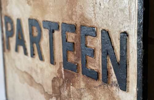
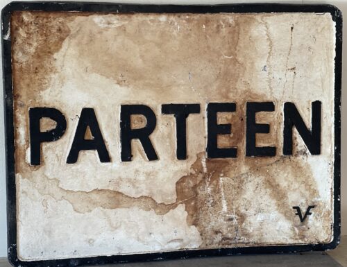 62cm x 45cm
An absolute once off piece of Irish Memorabilia .We at the Irish Pub Emporium were so lucky to acquire from a private collector .These superb castiron road signs were commissioned by the Irish Free State in the late 1940s post and were initially the responsibility of the newly formed Irish Tourism Organisation -Fógra Failte (later to become Bord Failte and then Failte Ireland).
"The former 'fingerpost' style of Irish directional signs can still be seen in many rural areas of the Republic of Ireland. These signs differ from their modern-day equivalent as they have black raised text on a white background. Destinations are in all caps (the placename in Irish was on top and in a smaller font than the one in English). Sometimes, the former route number ("T" for trunk road, "L" for link road) can be seen, and the former Bord Fáilte logo can be seen on some (they had responsibility for signs for a time), as well as occasionally a harp. Distances on these signs are in miles.
This style of sign has become a common feature of many tourist images of Ireland and can be seen in some Irish pubs. However, they can be easily rotated, and have been done so on occasion and therefore are not completely reliable. While most examples of these signs still in situ are rural finger-posts, the advance directional sign of this era can still very occasionally be seen: this has a grey background, with the destinations in outlined, white-background boxes linked together with black lines, and the text is not raised on these, unlike on fingerposts. These signs, rare even when the system was in use, can be seen in some areas of Dún Laoghaire and Drogheda. These signs were prescribed under various regulations, with the final design prescribed under the Road Traffic Signs (Regulations) 1962.
Despite the new sign style being introduced in 1977, the design change was never legislated for (apart from a reference to the change to italics in 1989) and the old designs were repealed only under the 1997 regulations, 20 years later.
62cm x 45cm
An absolute once off piece of Irish Memorabilia .We at the Irish Pub Emporium were so lucky to acquire from a private collector .These superb castiron road signs were commissioned by the Irish Free State in the late 1940s post and were initially the responsibility of the newly formed Irish Tourism Organisation -Fógra Failte (later to become Bord Failte and then Failte Ireland).
"The former 'fingerpost' style of Irish directional signs can still be seen in many rural areas of the Republic of Ireland. These signs differ from their modern-day equivalent as they have black raised text on a white background. Destinations are in all caps (the placename in Irish was on top and in a smaller font than the one in English). Sometimes, the former route number ("T" for trunk road, "L" for link road) can be seen, and the former Bord Fáilte logo can be seen on some (they had responsibility for signs for a time), as well as occasionally a harp. Distances on these signs are in miles.
This style of sign has become a common feature of many tourist images of Ireland and can be seen in some Irish pubs. However, they can be easily rotated, and have been done so on occasion and therefore are not completely reliable. While most examples of these signs still in situ are rural finger-posts, the advance directional sign of this era can still very occasionally be seen: this has a grey background, with the destinations in outlined, white-background boxes linked together with black lines, and the text is not raised on these, unlike on fingerposts. These signs, rare even when the system was in use, can be seen in some areas of Dún Laoghaire and Drogheda. These signs were prescribed under various regulations, with the final design prescribed under the Road Traffic Signs (Regulations) 1962.
Despite the new sign style being introduced in 1977, the design change was never legislated for (apart from a reference to the change to italics in 1989) and the old designs were repealed only under the 1997 regulations, 20 years later. -
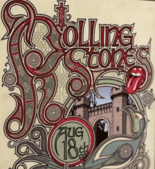
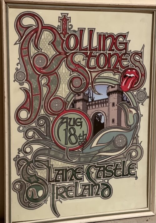 42cm x 31cm
Speaking to the Irish Times in 2007 about the Rolling Stones’s 1982 concert, Slane Castle owner Lord Henry Mount Charles said Ireland had never seen anything like it before.
“The weather was beautiful, the show was magic. Mick Jagger came down the Thursday before the show and had dinner in the castle and the production crew slept in the drawing room of the castle the night before the show. It had an almost gypsy-like quality about it.”
Some 70,000 music fans paid £12 each for a ticket in 1982. Thousands arrived the night before to camp out wherever they could find a pitch around the village. Fans complained of being charged £5 for a six-pack of beer and £1 for a can of Coke, with one newspaper report at the time remarking that “every kind of huckster, three-card-trick man and itinerant salesman had a stall in Slane”.
The day of the concert, July 24th, saw brilliant sunshine, with those who weren’t sprayed by two massive water hoses taking advantage of the lack of security to swim in the River Boyne.
After the warm-up acts, which included the Chieftains, the Rolling Stones bounded on, with Mick Jagger proclaiming: “It’s great to be back in Dublin. After 16 years, it’s very nice of you to come, so let’s spend the night together.” Jagger showed a hazy knowledge of Irish geography and also of the band’s own history. They had last played Ireland in 1965.

Aerial view of the 80,000-strong crowd at the Rolling Stones in Slane, July 1982. Photograph: Tom Lawlor Concert report, Slane, 1982, by Maev Kennedy
They were a pretty audience. They brought their babies and some of them brought their mammies.In the interminable gaps between the live music they shinned over the 10-foot fence to leap into the Boyne and every mother’s son and daughter of them was decently clothed. Some stripped down to pants, some modestly leaped in fully clothed.
A ferocious, savage, vicious, terrifying gang of Hell’s Angels, from the badlands of Waterford, sat in a reeking huddle on the grass, shunned by 20 yards by the rest of the crowd. Hunched menacingly in their colours, they were eating Choc-Ices.
The crowd got younger all the way into the centre. Half way down were the 20-year-olds, sprawled out on rugs with their wine, in plastic bottles as per instructions, and their dope. The worst crime they committed was to fall sound asleep in the hot sun, and some slept right through the Stones.
Only in the first 10 rows, damped down by fire hoses and at one ecstatic moment sprayed with fire hose by Mick Jagger HIMSELF was there that wild dangerous electric excitement the media associates with huge rock concerts. They leaped and shrieked and held up imploring arms.


“You’re all right!” Mick Jagger yelled at them. “You’re not too bad yourself!” they shouted back.
Up at the top of the hill, up at the top of a 60 foot pine tree, a lunatic fan leaped up and down hysterically.
“It’s great to be back in Dublin,” Jagger assured them. Nobody had the heart to correct him.
By the last chords of the opening Under My Thumb a steady stream of denim was pouring up the slopes and out the gate. They’d waited 10 hours to see the Rolling Stones, and they’d seen the Rolling Stones; they knew exactly what they were going to play, so they left, perfectly happy.
People kept comparing the Stones concert to the Pope’s visit, but nobody ever left a Papal gig before the Last Blessing.
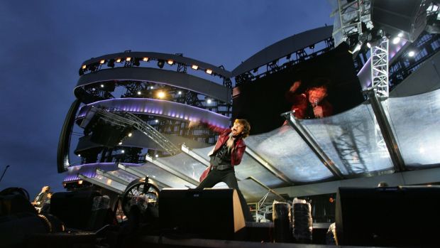
Returning after 25 years to Slane Castle, Mick Jagger performs to a crowd of 70,000 on Saturday 18th August, 2007. Photograph: Kate Geraghty Concert report, Slane, August 2007
“Is it a bit much?” Mick Jagger asked while the central section of the massive stage, on which the Rolling Stones stood, levitated away from their backing band and moved through the awestruck crowd.
Excess is a term that has long been associated with the Stones, and their hi-tech, high energy performance seemed to strike the right chord with fans.
Concert goers who had paid some €60 extra for “Gold Circle” tickets, which entitled them to a standing space at front of the stage, most certainly got their money’s worth, as they stood a hair’s breadth away from their idols. Eventually the stage retracted and the show continued as before.
However, for some fans, the moment they stood beside the Rolling Stones will live long in memory.
Mick Jagger remains a remarkably competent frontman, with an impressive swagger, and his banter during the interludes had the crowd hanging on his every word.
He gave fans an obligatory few words “as Gaeilge” and to his credit, and much to the fans’ delight, his diction was spot on.
Another big cheer came when Jagger introduced guitarist Ronnie Wood to the crowd, describing him as a man from Naas, where Wood now has a home. Wood grabbed the microphone from his mate and bellowed “come on the Royals”, to a somewhat mixed reaction.
Dave Fanning: Slane 1982 was ‘a big circus’
Dave Fanning spoke to The Irish Times in 2007: “I remember the first Slane, standing backstage and watching Phil Lynott arrive by helicopter. There wasn’t such a big vibe about hanging around the castle – everyone was either in the crowd or backstage.
“1987 was memorable because I was seeing one of my favourite people fail miserably: David Bowie. That was also the year I got my binoculars nicked.
“The Rolling Stones in 1982 was like a great big circus, and the stage had these two big catwalks that spread right out into the crowd like a pair of wings. When Keith Richards walked down one of the catwalks, he was standing just 50 yards from us, and that was cool.“Bruce was the biggest thing going in 1985, but Slane was the biggest crowd he had played to up till then. Bob Dylan did a solid enough gig in ’84, but he played as if he was in the Baggot.
“Queen was the first Slane where it rained, and there was a bad vibe with the crowd down the front, because there were so many people there.”

Returning after 25 years to Slane Castle, Mick Jagger performs to a crowd of 70,000 on Saturday 18th August, 2007. Photograph: Kate Geraghty BP Fallon: 1982 wasn’t a patch on 2007
BP Fallon spoke to The Irish Times in 2007 about his memories of 1980s Slane: “Dylan was the most memorable one for me – he had a great band which included Mick Taylor (ex-Rolling Stones) and Ian McLagan (ex-Faces).
“The worst Slane was definitely David Bowie – all that Glass Spider rubbish and those dancers. Terrible. I didn’t go to Queen on principle, because they had played in South Africa during the apartheid regime. I saw The Rolling Stones gig, but it wasn’t a patch on the [2007] tour.”
