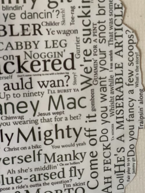
Every country has its own slang terms or local colloquialisms and Ireland is no different. Many of the country's famous sayings are well-known worldwide, but there may be one or two you're not familiar with. No doubt you'll be wanting to experience the 'craic' for yourself as you explore your new surroundings, so we've put together this 'bang-on' guide to the local lingo!
Craic is probably the most popular and familiar slang phrase, simply meaning ‘fun’ or ‘banter’, just good times. It has origins with the Ulster Scots, who told of the crack, the Gaelic spelling not fully popularised in Ireland until the 1970s, when it was the catchphrase of the Irish-language TV show SBB ina Shuí.
Some other slang phrases might not be quite as familiar, and each region of Ireland has its own particular lingo, but here are some of the weird and wonderful words and phrases that might come in handy, and save you from making an eejit or a gowl of yourself!
Gowl: An annoying person. Ah, ye GOW-EL ye!
Wisht: Shush! A handy one for in the cinema, or for chatterboxes in lectures.
Scarlet: Embarrassed. Hopefully not because you’ve been a gowl. I was such an eejit, I was scarlet!
Wired to the moon: Maybe you’ve been out late, enjoying the craic a little too much, and you’ve grabbed a triple espresso on the way to the lecture theatre? You’re wired to the moon.
Wee: Small, but everything in Ireland is wee. If Dwayne ‘The Rock’ Johnson were to visit Ireland, he’d be Wee Dwayne.
Quare: Meaning ‘great’. It’s quare weather out today! Also used for ‘very’. It’s quare warm today!
Savage: Something excellent. Was it a good craic last night? Oh, it was savage!
The Jacks: The toilets, fir jacks for the mens, ban jacks for the ladies, not to be confused with…
Banjaxed: Broken. Ruined.
Happy out: Simply happy. You’re enjoying the craic, having a quare old time, you’re happy out.
Sure look at it: A suitable reply to nearly any statement. Isn’t this weather grand? Ah, sure look at it!
Ossified: Very drunk. Regretfully so. See also: langers, blathered, locked.
The messages: If you hear people referring to doing the messages, they're going shopping. Does anyone need anything? I’m heading out to do the messages.
The press: An Irish term for the cupboard. You might want to check you’ve enough biscuits in the press, before you set off to do the messages.
Are you okay?: If the barman is asking you this, he’s not checking on your state of being, simply wanting to know what you want to order.
I’ve a throat on me: Thirsty. Just don’t get too ossified and make an eejit of yourself!
Me ould segotia, me ould sweat, me ould flower: Best friend.
Aculsha: An old term of affection, from a chuisle mo chroí, ‘pulse of my heart’
A soft day: A drizzly rainy, misty day.
Acting the maggot: Being silly, making a nuisance. An annoying person.
Making a bags of it: Making a mess of something.
Cat altogether: Something bad. If the weather is terrible, it could be cat altogether out there.
Even if you’re apprehensive about using some of these phrases in your conversations, it’ll certainly help you understand what your new Irish friends are saying. Ah, it was quare warm yesterday, I’d meant to do the messages, but I’d quite the throat on me. I got utterly langers, made a right gowl of meself acting the maggot, and I’m totally banjaxed today. Savage!
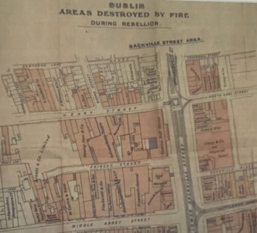
42cm x 42cm Dublin
The Easter Rising was an insurrection, mostly in Dublin city, that lasted from April 24th until April 30th1916.
The insurgents in Dublin amounted to 1,200 men and women from the nationalist militia the Irish Volunteers, the socialist trade union group Irish Citizen Army and the women’s group, Cumman na mBan.
The Irish Volunteers had been founded in 1913 in response to the blocking of Home Rule, or self government for Ireland by the Ulster Volunteers. The Citizen Army (with around 300 members) was formed during the Dublin Lockout of 1913 to protect strikers from the police. James Connolly afterwards directed it towards pursuit of an Irish socialist republic.
The Volunteers split after the outbreak of the First World War into the National Volunteers and the Irish Volunteers.
The National Volunteers, over 120,000 strong, led by Irish Parliamentary Party leader John Redmond, were pledged to support the British war effort and over 30,000 of them joined the British Army. The remaining 13,000 Irish Volunteers, led by Eoin MacNeill, were committed to keep their organisation intact and in Ireland until Home Rule was passed.
The Rising was planned in secret by seven men, mostly of the Irish Republican Brotherhood or IRB, who had formed a “Military Council” to this end just after the outbreak of the First World War. They were, Tom Clarke, Sean McDermott, Patrick Pearse, Thomas MacDonagh, Joseph Plunkett, James Connolly and Eamon Ceannt.
Their plans were not known to the membership of the Volunteers at large or to the leaders of the IRB and Volunteers, Dennis McCullough, Bulmer Hobson and Eoin MacNeill.
They had arranged with the Germans for a large importation of arms to be delivered on Good Friday, April 21st, but this shipment was discovered by the British off Kerry and its cargo lost.
At the last minute, the plans for the Rising were revealed to Eoin MacNeill who tried to call off the rebellion by issuing a “countermanding order”, but actually just postponed the outbreak from Easter Sunday to the next day, Monday.
The insurgents proclaimed an Irish Republic with Pearse as President and Connolly as commander in chief. They occupied positions around Dublin at the General Post Office (GPO), the Four Courts, the South Dublin Union, Boland’s Mill, Stephen’s Green and Jacobs’ biscuit factory.
The GPO in ruins after the Rising.
Over the following week, the British deployed over 16,000 troops, artillery and naval gunboat into the city to suppress the rising. In the week’s fighting, about 450 people were killed and over 2,000 wounded.
The rebels’ headquarters at the GPO was bombarded into surrender, which Patrick Pearse ordered on Saturday, 29th April.However the fiercest fighting took place elsewhere, at Mount Street Bridge, South Dublin Union and North King Street.
There were also risings in county Galway, Enniscorthy in Wexford and Ashbourne in county Meath, but apart from an action at Ashbourne that killed 11 police, these caused little bloodshed.
Sixteen of the rebel leaders were executed, 15 in a two week period after they had surrendered and one, Roger Casement, in August.
Over 3,000 people were arrested after the rebellion and over 1,400 imprisoned. The Rising was not widely supported among the Dublin public and was condemned by the Irish Parliamentary Party and much of nationalist as well as unionist opinion. However, combined with other factors, such as the continued postponement of Home Rule, the growing casualties of the First World War and the threat of conscription, the Rising and its repression helped to increase the strength of the radical nationalists in Sinn Fein.
This party, which had not participated in the rebellion, was adopted as a vehicle by the veterans of the Rising and pledged to withdraw from the Westminster Parliament and set up an Irish one.
Sinn Fein went on to win three by-elections in 1917 and a general election in 1918, leading to their proclamation of an Irish Republic in January 1919 and the start of the Irish War of Independence.
33cm x 57cm
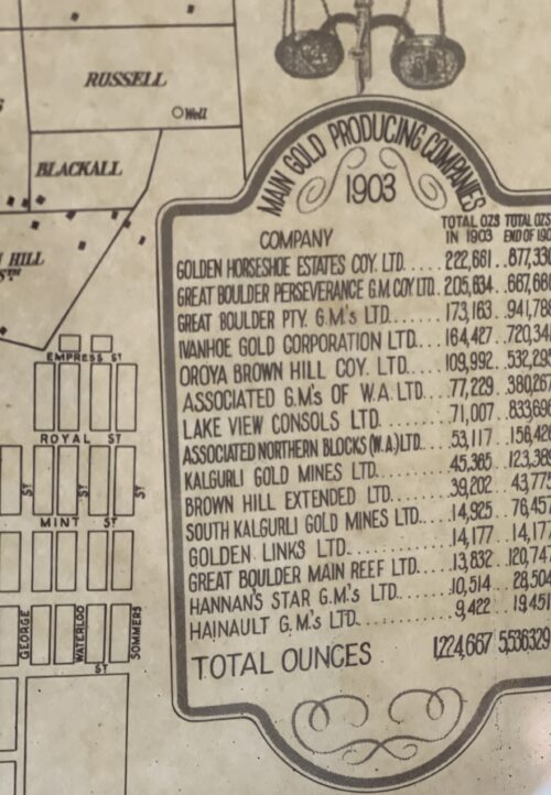
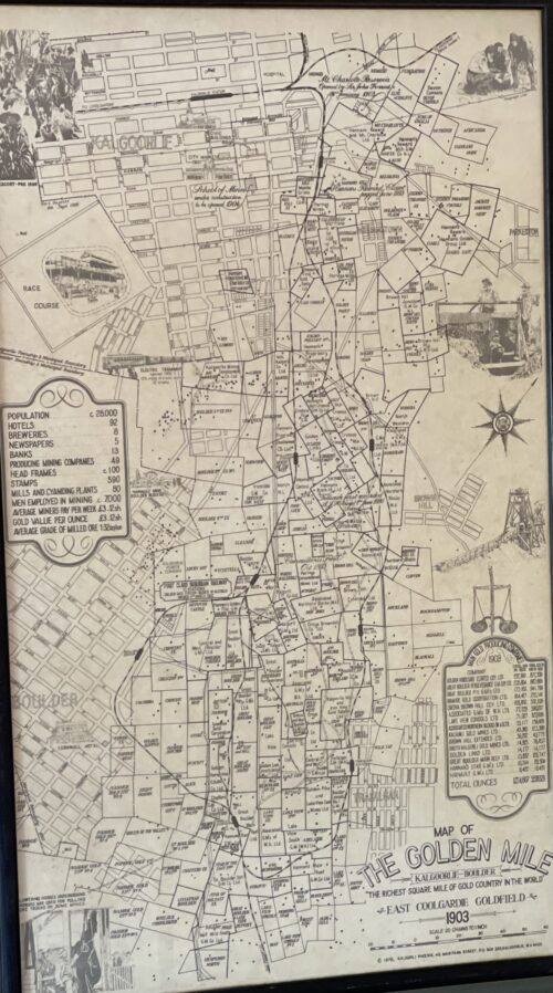
In the winter of 1893, prospectors Patrick (Paddy) Hannan, Tom Flanagan, and Dan Shea were travelling to Mount Youle, when one of their horses cast a shoe. During the halt in their journey, the men noticed signs of gold in the area around the foot of what is now the Mount Charlotte gold mine, located on a small hill north of the current city, and decided to stay and investigate. On 17 June 1893, Hannan filed a Reward Claim, leading to hundreds of men swarming to the area in search of gold, and Kalgoorlie, originally called Hannan's Find, was born.
Hannan Street in September 1930; the Exchange Hotel is at the centre, with the Palace Hotel on the right.
The population of the town was 2,018 (1,516 males and 502 females) in 1898.
The mining of gold, along with other metals such as nickel, has been a major industry in Kalgoorlie ever since, and today employs about one-quarter of Kalgoorlie's workforce and generates a significant proportion of its income. The concentrated area of large gold mines surrounding the original Hannan's find is often referred to as the Golden Mile, and was sometimes referred to as the world's richest square mile of earth.
In 1901, the population of Kalgoorlie was 4,793 (3,087 males and 1,706 females) which increased to 6,790 (3,904 males and 2,886 females) by 1903.
The 3 ft 6 in (1,067 mm) narrow-gauge GovernmentEastern Goldfields Railway line reached Kalgoorlie station in 1896, and the main named railway service from Perth was the overnight sleeper train The Westland, which ran until the 1970s. In 1917, a 4 ft 8+1⁄2 in(1,435 mm) standard gaugerailway line was completed, connecting Kalgoorlie to Port Augusta, South Australia, across 2,000 kilometres (1,243 mi) of desert, and consequently the rest of the eastern states. The standardisation of the railway connecting Perth (which changed route from the narrow-gauge route) in 1968 completed the Sydney–Perth railway, making rail travel from Perth to Sydney possible; the Indian Pacific rail service commenced soon after. During the 1890s, the Goldfields area boomed as a whole, with an area population exceeding 200,000, composed mainly of prospectors. The area gained a reputation for being a "wild west", notorious for its bandits and prostitutes. This rapid increase in population and claims of neglect by the state government in Perth led to the proposition of the new state of Auralia, but with the sudden diaspora after the Gold Rush, these plans fell through.
Places, famous or infamous, for which Kalgoorlie is noted include its water pipeline, designed by C. Y. O'Connor and bringing in fresh water from Mundaring Weir near Perth, its Hay Street brothels, its two-up school, the goldfields railway loopline, the Kalgoorlie Town Hall, the Paddy Hannan statue/drinking fountain, the Super Pit, and Mount Charlotte lookout. Its main street is Hannan Street, named after the town's founder. One of the infamous brothels also serves as a museum and is a major national attraction.
Paddy Hannan was the son of John Hannan and Bridget Lynch, and was baptised on 26 April 1840 in the town of Quin, County Clare, Ireland. His baptismal record shows that his godparents (sponsors) were Margaret Lynch and John O'Brien. Many of the people in his family emigrated to Australia from 1852 onwards, and close ties were maintained. Two of Hannan's nieces would welcome Hannan into their house for the last years of his life.
Hannan emigrated to Australia when he was 22, arriving in Melbourne on 23 December 1862 aboard the Henry Fernie from Liverpool. He is recorded in the passenger list as Pat Hannan, a labourer.
Prospecting success
Hannan's Western Australian miner's right, 1893
In 1893 in Western Australia, Hannan and his partners were the first to find gold near Mount Charlotte, less than 40 kilometres from the existing Coolgardie Goldfields. Hannan, Flanagan and Shea were following a large number of prospectors who set out for a rumoured new prospect at Mount Youle.
One version of the story of the find has it that on the night of 14 June 1893, Hannan found gold in a gully. Not wanting to cause a rush, he concealed the find. During the night the trio moved one of their horses into the scrub. The following morning Hannan informed the main party they were going to stay behind to find their lost horse. After the main group moved off east, the three men started to pick up the gold and peg out their lease.
Amongst the various counter-claims to emerge over the years, one lively version of the story was told in 1909 by Fred Dugan (another prospector, who was present at the time) relating how Thomas Flanagan found the first nuggets, and covered his find with brushwood to conceal it until the following day.
By law, those finding "payable" gold were required to report the fact to the warden's office within seven days, so Hannan set off for Coolgardie to register their find, doing so on 17 June 1893.
It has been suggested that Hannan, rather than Flanagan or Shea, was chosen to officially register the claim because only he could read and write, but there is evidence that Flanagan was literate, since, in 1864, he had clearly signed the official death certificate of his brother John Flanagan, and had written his own place of residence at the time - White Hills (in Bendigo, Victoria, Australia).
The other possible reasons for Hannan going alone to the office at Coolgardie are set out by Martyn Webb,who relates that:
The fact that Flanagan and Shea were able to secure another 100 ounces while Hannan was away registering their claim at Coolgardie might help to explain why Hannan was chosen ... simply because they were better at specking than he was – it needs good eyesight. On the other hand, since the journey was arduous and had to be done as quickly as possible, Hannan might have been chosen because, as Uren and others suggest, he was the youngest and the fittest of the three. … The most likely reason … was that he was the undisputed leader of the party.
— Webb, p. 103
Hannan registered the claim in Flanagan's name as well as his own. Within hours a stampede began. It was estimated that about 400 men were prospecting in the area within three days, and over 1,000 within a week.
Final years
Hannan's grave in Melbourne Central Cemetery, Section Y
In 1904, at the age of sixty-four, Hannan was granted an annual pension of £150 by the Government of Western Australia.
Having searched for gold throughout his adult life, he did not cease his prospecting activities until after 1910, his seventieth year. At that time he went to live with two of his nieces in Fallon Street, Brunswick, Victoria (close to the city of Melbourne).
He died there in 1925 and was buried in Melbourne Central Cemetery, in the Catholic section, near the North Gate.
In 1993 his grave was restored by the citizens of Kalgoorlie, led by Tess Thomson, as a part of the celebration of the 100-year anniversary of the original find by Hannan, Flanagan and Shea.
Legacy
1929 statue of Paddy Hannan in Kalgoorlie, Western Australia
In memory of a man who is regarded as the founder of Kalgoorlie, the main street and a suburb in Kalgoorlie both bear Hannan's name, and in 1929 a statue of him by the sculptor John MacLeod was erected there.
The city boasts several commemorative plaques to the three Irishmen, Hannan, Flanagan and Shea. A popular Irish pub at the Burswood Entertainment Complex was also named after Hannan.
In Ireland there is a plaque dedicated to his memory opposite Quin Abbey, Quin, County Clare, and there is a bust with an explanatory dedication on display inside the DeValera Library in Ennis, County Clare.
35cm x 40cm Limerick City
The definitive Ferrars History of Limerick was first published in 1787
There are very few copies still in existence and these 5 prints were generously taken from 16 original engravings in the first edition .
Castleconnell, picturesquely situated on a rock overlooking the Shannon, about six miles north of Limerick, became the principal castle of the Bourkes in West Clanwilliam. This was the ancient seat of the O'Conaings, and took their name Caislean-ui-Chonaine. It subsequently fell into the possession of the O'Briens of Thomond. King John made a grant of Castleconnell, with five knights' fees, to William de Burgh, who erected a strong castle there. Walter De Burgh, about the end of the thirteenth century, considerably enlarged and strengthened this castle, which was the chief stronghold of his descendants at the end of the sixteenth century.
The History of Limerick by James Ferrar published in 1787 is a history of Limerick city from ancient times until the late 18th century. Limerick was an important medieval stronghold, became an important port and trading centre, was subject to a series of sieges in the 17th century and finally experienced a brief golden age of prosperity during the Georgian period of the late 18th century.
Limerick or Luimneach was an ancient settlement long before the Vikings captured it and established their own town there in the 9th century. They used it as a base for trade and also to launch raids up the River Shannon against monastic sites like Clonmacnoise and other wealthy Christian centres. However in the 11th century the last Viking king of Limerick was defeated by King Brian Boru.
In 1174, the Norman conquerors who had already seized Dublin , Leinster and Munster captured the city of Limerick . It was given its city charter by King Richard I in 1197 and a castle fortress was built by King John about 1200. The medieval city featured a walled town known as Englishtown on the north side of the River Shannon. Irishtown was inhabited by the Irish and Vikings was on the south side of the river. Both were eventually walled and linked by bridges over the Shannon .
Limerick would retain formidable defenses until the 17th century when it experienced four separate sieges during the period of the English Civil War and the Williamite Wars. Catholic rebels forced the English garrison to surrender in 1642 and a Parliamentarian Army in turn forced a Catholic and Royalist garrison to surrender in 1651. It was twice besieged in 1690 and 1691 by the forces of William III of Orange who forced Jacobins fighting on the sides of the Catholic James II to surrender and go into exile.
From the late 17th to the 19th centuries an Anglo-Irish Protestant elite controlled Ireland . In Limerick in the late 1700s Limerick merchants prospered and Edmund Pery, 1st Viscount Pery had much of the south side of the city redesigned with a grid of Georgian brick terraces and neo-classical stone buildings. The Georgian area still survives in the 21st century and Prey Square is named in Edmund Prey's honour.
Unfortunately the Irish economy declined in the early 19th century as the Irish Parliament was switched from College Green, Dublin to the House of Commons in London and Ireland remained a near feudal agricultural society as Britain rapidly industrialised. Like Dublin , Limerick 's best days were behind it as slums flourished and in the 1840s the city population swelled as the poor fled from the land after the failure of the potato crop.
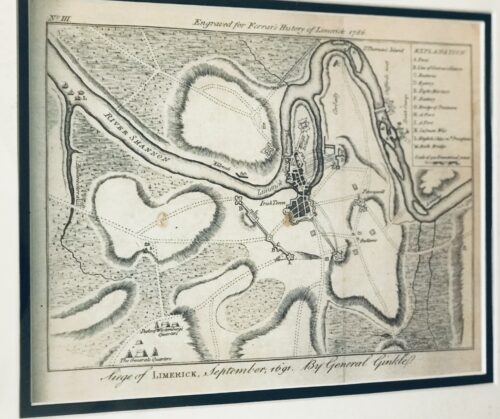
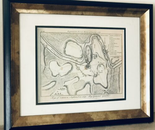
The Siege of Limerick 1691 from the definitive Ferrars History of Limerick was first published in 1787
There are very few copies still in existence and these 5 prints were generously taken from 16 original engravings in the first edition .
35cm x 40cm Limerick
The Siege of Limerick in western Ireland was a second siege of the town during the Williamite War in Ireland (1689–1691). The city, held by Jacobite forces was able to beat off a Williamite assault in 1690. However, after a second siege in August–October 1691, it surrendered on favourable terms.
By the time of the second siege, the military situation had turned against the Jacobites; their main force had been badly defeated at the Battle of Aughrim in July, with over 4,000 killed, including their commander, the Marquis de St Ruth, and thousands more either taken prisoner or deserted. The town of Galway capitulated in July 1691; its Jacobite garrison was accorded 'all the honours of war,' which allowed them to retain their weapons and receive a free pass to Limerick.
Siege of Limerick 1691, map.
However, although its defences had been considerably strengthened since 1690, morale was now much lower after a series of defeats and retreats. By now, siege warfare was an exact art, the rules of which were so well understood wagering on their outcome and duration had become a popular craze; the then enormous sum of £200,000 was alleged to have been bet on the siege. The Williamite general Godert de Ginkell surrounded the city and bombarded it, tearing a breach in the walls of English town. A surprise Williamite attack drove the Irish defenders from the earthworks defending Thomond bridge, sending its Irish defenders reeling back towards Limerick. The French defenders of the main gate of the city refused to open it for the fleeing Irish and about 800 of them were cut down or drowned in the river Shannon.
Capitulation and treaty
After this point, Patrick Sarsfield ousted the Chevalier de Tessé and the Marquis d'Usson, the French commanders in Limerick, and began negotiations to surrender. He and Ginkel concluded a treaty that promised to respect the civilian population of Limerick, tolerate the Catholic religion in Ireland, guarantee against the confiscation of Catholic-owned land and allow Sarsfield and the fully-armed Jacobite army to withdraw to France. Limerick capitulated under those favourable terms in October 1691. Sarsfield left Ireland with 10,000 soldiers and 4,000 women and children to enter the French service, a journey that has become known as the Flight of the Wild Geese.
The terms of the Treaty of Limerick were not honoured by the 1697 Protestant-dominated Irish Parliament, and Catholics were subjected to the continuous oppression of the Penal Laws, which discriminated against them until the early 19th century
The History of Limerick by James Ferrar published in 1787 is a history of Limerick city from ancient times until the late 18th century. Limerick was an important medieval stronghold, became an important port and trading centre, was subject to a series of sieges in the 17th century and finally experienced a brief golden age of prosperity during the Georgian period of the late 18th century.
Limerick or Luimneach was an ancient settlement long before the Vikings captured it and established their own town there in the 9th century. They used it as a base for trade and also to launch raids up the River Shannon against monastic sites like Clonmacnoise and other wealthy Christian centres. However in the 11th century the last Viking king of Limerick was defeated by King Brian Boru.
In 1174, the Norman conquerors who had already seized Dublin , Leinster and Munster captured the city of Limerick . It was given its city charter by King Richard I in 1197 and a castle fortress was built by King John about 1200. The medieval city featured a walled town known as Englishtown on the north side of the River Shannon. Irishtown was inhabited by the Irish and Vikings was on the south side of the river. Both were eventually walled and linked by bridges over the Shannon .
Limerick would retain formidable defenses until the 17th century when it experienced four separate sieges during the period of the English Civil War and the Williamite Wars. Catholic rebels forced the English garrison to surrender in 1642 and a Parliamentarian Army in turn forced a Catholic and Royalist garrison to surrender in 1651. It was twice besieged in 1690 and 1691 by the forces of William III of Orange who forced Jacobins fighting on the sides of the Catholic James II to surrender and go into exile.
From the late 17th to the 19th centuries an Anglo-Irish Protestant elite controlled Ireland . In Limerick in the late 1700s Limerick merchants prospered and Edmund Pery, 1st Viscount Pery had much of the south side of the city redesigned with a grid of Georgian brick terraces and neo-classical stone buildings. The Georgian area still survives in the 21st century and Prey Square is named in Edmund Prey's honour.
Unfortunately the Irish economy declined in the early 19th century as the Irish Parliament was switched from College Green, Dublin to the House of Commons in London and Ireland remained a near feudal agricultural society as Britain rapidly industrialised. Like Dublin , Limerick 's best days were behind it as slums flourished and in the 1840s the city population swelled as the poor fled from the land after the failure of the potato crop.
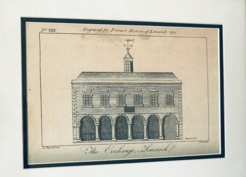
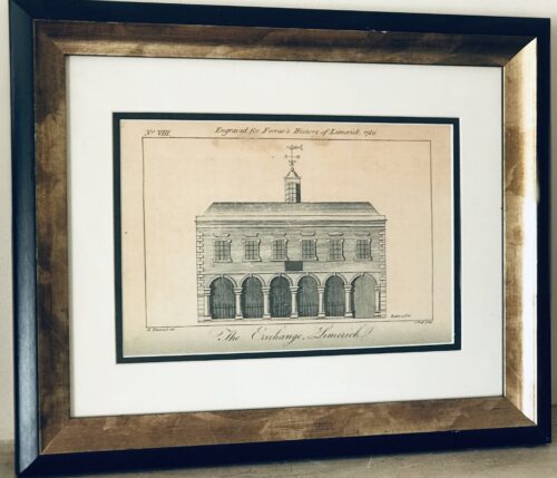
Superb print of The Exchange Limerick from Ferrars History of Limerick,first published in 1787.There are very few copies still in existence and these 5 prints were generously taken from 16 original engravings in the first edition .
35cm x 40cm Limerick
rcaded six-bay single-storey limestone exterior wall forming the remains of the former Exchange, originally built in 1673, rebuilt in 1702 and again in between 1777-78. Forms part of the wall which surrounds Saint Mary's Cathedral graveyard and faces onto Nicholas Street. Historically in use as an evening national school. Now much obscured by vegetative growth. The blind arcade of seven arches is formed by half-engaged Tuscan columns standing on limestone base, breaking to centre arch and end bay to west. Profiled archivolts unseen. Entablature to parapet obscured. Roughly squared and coursed rubble limestone infill between arches. At either end is an ashlar limestone pier engaged with end columns, giving strength of composition to the broad intercolumniation. Plaque to Cathedral wall reads: This Exchange Was Rebuilt At Expense Of The Corporation Of Limerick The First Year Of The Reign Of Queen Anne Anno Dom 1702 William Davis Esquire Mayor Rawley Colroys Robert Wilkinson Sheriffs'.
Appraisal
What remains of this impressive architectural composition is an important and enriching palimpsest to the site and complex of Saint Mary's Cathedral. The secular use of which shows the economic importance of the building given its proximity to the cathedral. Henry Denmead was responsible for the reworking in 1777-78. James Pain was paid £432.17s 5d for repairs and alterations in April 1815, while George Richard Pain carried out further repairs in June 1819 to the cost of £182.1s 2½ d. On the 1872 Ordnance Survey the building was in use as a national school, and the floor plan represented was of a single unified space opening onto Nicholas Street and three small secondary rooms to the rear. A passage or corridor to the west appears to have given access to the Church grounds, and the building to the rear looked onto a walled graveyard. A lane, now gone, called Grid Iron Lane, ran along the east side elevation of the structure, returning at right angles to meet Bridge Street.
The History of Limerick by James Ferrar published in 1787 is a history of Limerick city from ancient times until the late 18th century. Limerick was an important medieval stronghold, became an important port and trading centre, was subject to a series of sieges in the 17th century and finally experienced a brief golden age of prosperity during the Georgian period of the late 18th century.
Limerick or Luimneach was an ancient settlement long before the Vikings captured it and established their own town there in the 9th century. They used it as a base for trade and also to launch raids up the River Shannon against monastic sites like Clonmacnoise and other wealthy Christian centres. However in the 11th century the last Viking king of Limerick was defeated by King Brian Boru.
In 1174, the Norman conquerors who had already seized Dublin , Leinster and Munster captured the city of Limerick . It was given its city charter by King Richard I in 1197 and a castle fortress was built by King John about 1200. The medieval city featured a walled town known as Englishtown on the north side of the River Shannon. Irishtown was inhabited by the Irish and Vikings was on the south side of the river. Both were eventually walled and linked by bridges over the Shannon .
Limerick would retain formidable defenses until the 17th century when it experienced four separate sieges during the period of the English Civil War and the Williamite Wars. Catholic rebels forced the English garrison to surrender in 1642 and a Parliamentarian Army in turn forced a Catholic and Royalist garrison to surrender in 1651. It was twice besieged in 1690 and 1691 by the forces of William III of Orange who forced Jacobins fighting on the sides of the Catholic James II to surrender and go into exile.
From the late 17th to the 19th centuries an Anglo-Irish Protestant elite controlled Ireland . In Limerick in the late 1700s Limerick merchants prospered and Edmund Pery, 1st Viscount Pery had much of the south side of the city redesigned with a grid of Georgian brick terraces and neo-classical stone buildings. The Georgian area still survives in the 21st century and Prey Square is named in Edmund Prey's honour.
Unfortunately the Irish economy declined in the early 19th century as the Irish Parliament was switched from College Green, Dublin to the House of Commons in London and Ireland remained a near feudal agricultural society as Britain rapidly industrialised. Like Dublin , Limerick 's best days were behind it as slums flourished and in the 1840s the city population swelled as the poor fled from the land after the failure of the potato crop.
Ferrars History of Limerick was first published in 1787.There are very few copies still in existence and these 5 prints were generously taken from 16 original engravings in the first edition .They depict the Siege of Limerick in 1691,St Marys Cathedral,De Burgos Castle in Castleconnell,The Exchange building and the first page of the book.
35cm x 40cm Limerick
The History of Limerick by James Ferrar published in 1787 is a history of Limerick city from ancient times until the late 18th century. Limerick was an important medieval stronghold, became an important port and trading centre, was subject to a series of sieges in the 17th century and finally experienced a brief golden age of prosperity during the Georgian period of the late 18th century.
Limerick or Luimneach was an ancient settlement long before the Vikings captured it and established their own town there in the 9th century. They used it as a base for trade and also to launch raids up the River Shannon against monastic sites like Clonmacnoise and other wealthy Christian centres. However in the 11th century the last Viking king of Limerick was defeated by King Brian Boru.
In 1174, the Norman conquerors who had already seized Dublin , Leinster and Munster captured the city of Limerick . It was given its city charter by King Richard I in 1197 and a castle fortress was built by King John about 1200. The medieval city featured a walled town known as Englishtown on the north side of the River Shannon. Irishtown was inhabited by the Irish and Vikings was on the south side of the river. Both were eventually walled and linked by bridges over the Shannon .
Limerick would retain formidable defenses until the 17th century when it experienced four separate sieges during the period of the English Civil War and the Williamite Wars. Catholic rebels forced the English garrison to surrender in 1642 and a Parliamentarian Army in turn forced a Catholic and Royalist garrison to surrender in 1651. It was twice besieged in 1690 and 1691 by the forces of William III of Orange who forced Jacobins fighting on the sides of the Catholic James II to surrender and go into exile.
From the late 17th to the 19th centuries an Anglo-Irish Protestant elite controlled Ireland . In Limerick in the late 1700s Limerick merchants prospered and Edmund Pery, 1st Viscount Pery had much of the south side of the city redesigned with a grid of Georgian brick terraces and neo-classical stone buildings. The Georgian area still survives in the 21st century and Prey Square is named in Edmund Prey's honour.
Unfortunately the Irish economy declined in the early 19th century as the Irish Parliament was switched from College Green, Dublin to the House of Commons in London and Ireland remained a near feudal agricultural society as Britain rapidly industrialised. Like Dublin , Limerick 's best days were behind it as slums flourished and in the 1840s the city population swelled as the poor fled from the land after the failure of the potato crop.
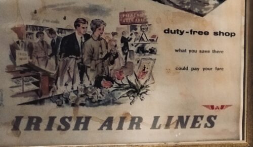
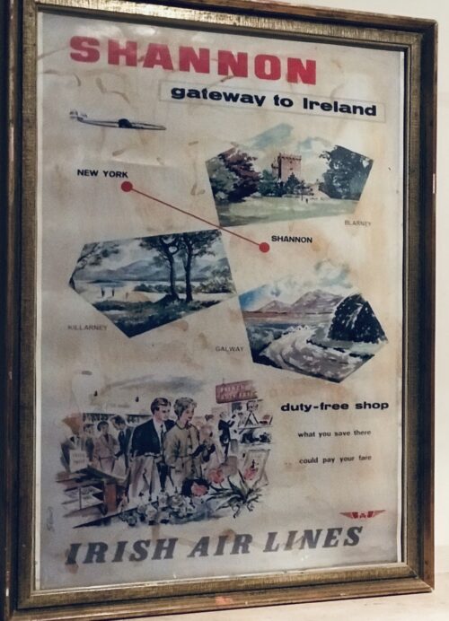
Interesting Shannon Airport Irish Air Lines retro advert.
Origins : Bunratty Co Clare. Dimensions : 70cm x 50cm
Worldwide Duty Free selling is a $70 billion business, but it has its origins in the mind of one Clare man. And like many innovations, the concept of duty free, which first came to Shannon Airport in 1952, was born of necessity.Today the global travel retail business is a firm fixture at airports across the world, and the concept has made a lot of money for a lot of people.But not for Brendan O’Regan, the man with the idea.
He was born into “the first generation of free Irish men” in relatively well-off surroundings in Sixmilebridge, Co Clare in 1917. His father, James, was chairman of Clare County Council and a successful businessman. The family was in the hotel business, and for a time leased the renowned Falls Hotel in Ennistymon and the Old Ground in Ennis. Sent as a boarder to Blackrock College in Dublin in 1931, O’Regan enjoyed early renown when he requested that the college, which by then had given up on the camán, field a hurling team in the Leinster Colleges cup.
His next step after school was training in hotel management, an interest that brought him to Germany, France and the UK, before coming home to run The Falls. He then moved to the ailing St Stephen’s Green club in Dublin, before being appointed catering comptroller at Foynes flying boat base in Co Limerick, then a refuelling point for transatlantic seaplanes.
It was here his passion for travel took off, but it was his next move that sealed his legacy.
Shannon Airport
Rineanna on the Shannon estuary in Co Clare, chosen by then taoiseach Seán Lemass as the site for a new airport for both sea and land planes, opened in October 1945, when the first transatlantic commercial air service from Boston landed there. It soon became Europe’s most important transatlantic airport, handling more than 100,000 passengers in 1946, its first full year of operation.
When O’Regan joined the nascent airport, its future was by no means secure. The imminent arrival of jet planes, which meant US planes would no longer have to stop in Shannon to refuel, was of concern, while the political apparatus of the day favoured focusing efforts on one airport in Dublin.
Fearing “economic annihilation” for the new airport, O’Regan sought a new venture that would help secure its future. Inspiration struck when he was returning home by sea from a visit to the United States, arranged under the Marshall Plan to allow the Irish government to study US tourism.
As told in the recently published book Brendan O’Regan: Irish Innovator, Visionary and Peacemaker by Brian O’Connell and Cian O’Carroll, O’Regan had a “eureka” moment on board.
“I saw the shop that was selling duty-free goods and my brain said to me: “If they can do it when you are crossing the sea in a boat, you can surely be able to do [it] when you land for the first time.”
He had to convince the Department of Industry and Commerce and the Revenue Commissioners of the merits of forgoing tax on the sale of goods, while local traders also opposed the move.
Nonetheless, O’Regan got the go-ahead and by July 1950 he had set up an operation in a timber hut outside the terminal, selling whiskey for $1.50 a bottle. The following year, the first duty-free shop in the world opened, with a bottle of whiskey on sale for just 30s, compared with 10s 6d in a regular shop, while in 1954 a mail order service was included. It went on to become a vast operation, mailing to locations all around the world, quality items such as crystal, china, fashionable clothing and jewellery.
Contagious idea
The concept soon caught on. In 1957 Amsterdam became the next airport to open a duty free, with the concept making its way across the Atlantic in 1962. Prince Philip was an early admirer of the concept, and he wanted it extended to all the UK’s international airports.
O’Regan also inspired philanthropist Chuck Feeney, who took the idea of duty free and galloped ahead with it, founding Duty Free Shoppers Group (DFS) in Hawaii in 1962, which later became the largest duty-free retailer in the world.
These years also saw the invention of Irish coffee, after O’Regan asked chef Joe Sheridan to “come up with something special” to warm up transatlantic passengers tired and cold after their trip.
But duty free was only part of the equation. O’Regan’s big dream was to position Shannon as the European manufacturing basis for US companies, and to bring employment and prosperity to the region.
Senator TK Whitaker, Brendan O’Regan (centre) and Dr Jerry Dempsey. Photograph: Peter Thursfield
Shaped by the devastating impact poverty and emigration had on the county of his birth, O’Regan often repeated his father’s maxim, that “the most important thing about life is to create work for others, if you can”.
In the 1950s, the post-war boom that lifted the US, Europe and the UK had missed Ireland, and emigration was running at the highest level since independence.
So O’Regan didn’t stop at the duty free.
In 1951, he established the Shannon College of Hotel Management, which is still operating today and the graduates of which have managed the world’s top hotels, while he also leveraged the area’s potential as a tourist hub. He identified the potential of Bunratty Castle as a tourist attraction and, with the co-operation of its owner, Lord Gort, it was renovated and opened to the public in 1960, with the first medieval banquet held shortly thereafter. O’Regan later chaired Bord Fáilte.
Great times
“He was very much a leader and innovative in the sense that he thought up ideas himself,” recalls O’Carroll, who worked alongside O’Regan as estates manager in the Shannon Free Airport Development Company Limited (SFADCO). “He would work very intensively until the project was launched, and then he would go on to the next project”.
It was a time of “brainstorming picnics”, and consultancy reports, to try and hit on a new idea.
“They were great times,” says O’Carroll. “If an idea came up, and it was any way worthwhile, it would stand a very good chance of implementation.”
The big move came in the establishment of the Shannon Free Zone, the world’s first free trade zone, in 1959, overseen by SFADCO. It operated a licensing system, offering qualifying companies a corporation tax rate of just 10 per cent; a model that would later be taken up by the IFSC.
O’Regan’s idea, inspired by the Free Zone in Colon, Panama, was greeted with much scepticism initially, but his ability to build good relationships, particularly with those in government, helped secure the initiative.
“He had the ability to short-circuit a lot of things in terms of procedures in getting approval,” says O’Carroll, adding that “this clearly annoyed civil servants at the time.”
Indeed his initials, BOR, in Shannon came to mean “Bash on regardless”.
So, on an “if you build it they will come” ambition, SFADCO set about building factories – without any tenants. A Dutch piano manufacturer owned by Johan J Rippen was the first real enterprise to come to Shannon, followed by Sony, and diamond company De Beers in 1960.
Tourism smarts
O’Regan also ramped up the region’s renown as a tourist destination, using his tools of persuasion to garner investment.
When Bernard McDonough, a wealthy Irish-American industrialist pulled out of a planned ball-bearing factory in the Shannon Free Zone, O’Regan told him about a nearby castle that was for sale. He took the bait and bought it; in 1963 Dromoland Castle opened as a five-star hotel. McDonough would later open a further three hotels in the area.
When he heard of a plan by German investors to acquire the land leading to the Cliffs of Moher, he rang then Clare county manager Joe Boland, who subsequently got the county council to buy it.
During the 1970s he moved away from his formal roles in Shannon, and turned his attention to the peace process, founding Co-operation North (now Co-operation Ireland) in 1979. He died in 2008, and a bronze bust sculpture was unveiled at Shannon Airport in May 2017 to mark the centenary of his birth.
A man of his time – as O’Carroll recalls, an “infinitely simpler” time – he nonetheless left a significant legacy.
As described when receiving an honorary degree from the National University of Ireland in 1978: “Rare is the man of whom it can be justly said that he transformed the social, economic and industrial life of a whole region”
The Shannon project was not just about creating jobs; it was also about providing homes for the workers who flocked there.
By the late 1950s the housing issue, which had plagued the development of the hub since the early days, was becoming a crisis. So, in 1960, a proposal was tabled for the creation of a new town; an innovation without precedent in post-war Ireland.
Inspired by the British new towns that arose after the war, including Crawleyin Sussex and Stevenage in Hertfordshire, Brendan O’Regan and his team sought to build a new hub for workers of the airport and the industrial zone.
The creation of the first new town in the history of the State was not without challenges; there were political ructions as to who would oversee the project – the government or SFADCO – while residents of nearby Limerick city accused Brendan O’Regan of “empire building”, as they rued the fact that the development did not happen in Limerick instead.
Nonetheless, by 1962 the first residents were moving in, all of whom were tenants of SFADCO and who had to work either in the airport or industrial area to qualify for affordable housing.
As SFADCO estates manager Cian O’Carroll recalls, building the houses so close to a place of huge employment was key, as was the fact that units were small – but even larger families were catered for.
“We often let them two houses and knocked them together,” he says.
Also key to its success was the fact that housing was affordable, and graded and related to people’s incomes. After some time a tenant purchase scheme was introduced, allowing people to buy their homes outright.
Today the town is home to some 10,000 residents, and remains one of the few examples of a new planned town in Ireland.
“It hasn’t grown as much as people might have expected, but it has its own social and economic viability,” says O’Carroll.
As to why subsequent governments haven’t looked to emulate the success of Shannon – particularly given our housing shortages – O’Carroll suggests it’s due to an ideological shift away from the State doing things directly themselves, instead encouraging the private sector to do the same through tax incentives and other methods.
“It’s a shame,” he says.
In the late 1930s, transatlantic air traffic was dominated by flying boats, and a flying boat terminal was located at Foynes on the south side of the Shannon Estuary. However, it was realised that changing technology would require a permanent runway and airport.
In 1936, the Government of Ireland confirmed that it would develop a 3.1-square-kilometre (1.2 sq mi) site at Rineanna for the country's first transatlantic airport. The land on which the airport was to be built was boggy, and on 8 October 1936 work began to drain the land. In July 1939, a SABENASavoia-Marchetti S.73 from Brussels via Croydon Airport was the first commercial flight to use the Rineanna airfield.[8] By 1942 a serviceable airport had been established and was named Shannon Airport. By 1945 the existing runways at Shannon were extended to allow transatlantic flightsto land.
When World War II ended, the airport was ready to be used by the many new post-war commercial airlines of Europe and North America. On 16 September 1945 the first transatlantic proving flight, a Pan AmDC-4, landed at Shannon from Gander. On 24 October 1945, the first scheduled commercial flight, an American Overseas Airlines DC-4, Flagship New England, stopped at the airport on the New York City–Gander–Shannon–London route.
An accident involving President Airlines on 10 September 1961 resulted in the loss of 83 lives. The Douglas DC-6 aircraft crashed into the River Shannon while leaving Shannon Airport for Gander.
The number of international carriers rose sharply in succeeding years as Shannon became well known as the gateway between Europe and the Americas; limited aircraft range necessitated refuelling stops on many journeys. Shannon became the most convenient stopping point before and after a trip across the Atlantic. Additionally, during the Cold War, many transatlantic flights from the Soviet Union stopped here for refueling, because Shannon was the westernmost non-NATO airport on the European side of the Atlantic.
On September 30, 1994 Shannon was the site of the "circling over Shannon" diplomatic incident involving Boris Yeltsin.
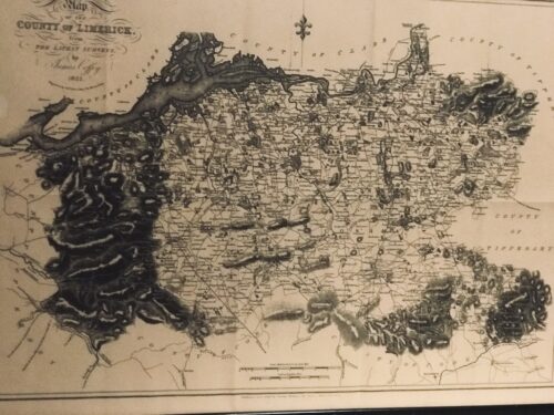
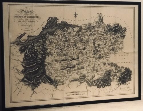
Very interesting map of Co Limerick from the 1825 surveys by the well known cartographer James Coffey.From the Latest Surveys. By James Coffey. 1825. Engraved by Sidney Hall, Bury Street, Bloomsbury. Published and sold by George McKern, 106, George Street, Limerick. Scale in Irish and English Miles. Framed and glazed.
Bruree Co Limerick 45cm x 60cm
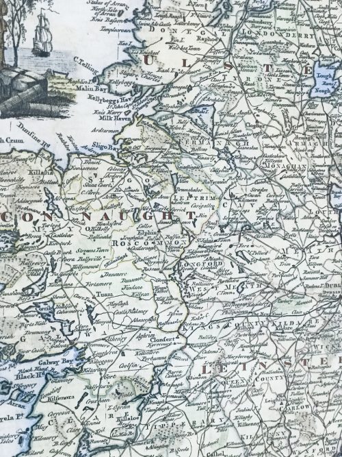
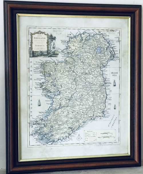
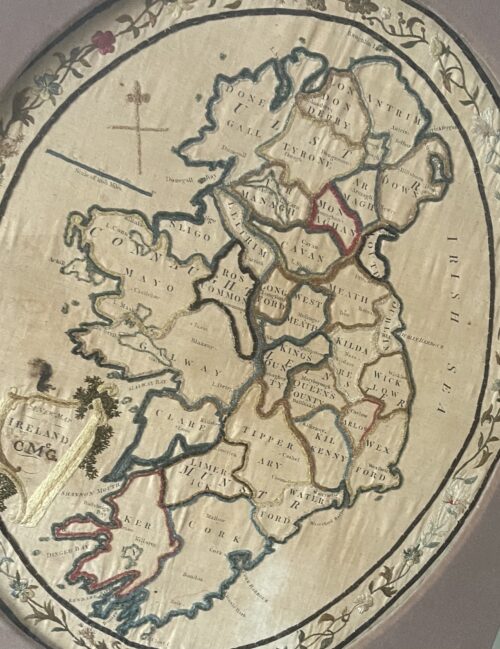
Very interesting and superbly framed New Map of Ireland from 1779 ( CMcG) from the latest surveys of the time.Please contact us directly at irishpubemporium@gmail.com for pricing and shipment quotation for this extraordinarily rare item.
Offset in a display type frame made by The Dawson Gallery 4 Dawson Street Dublin 2, we estimate this piece to be well over 200 years old.Long obsolete place names such as the ancient baronies of Blakeny Co Galway,Rofs Co Cork,Philipstown Co Laois and spellings such as Donegall,Lough Deirg & support this estimate.
70cm x 60cm Dublin
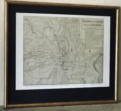
42cm x 48cm Limerick
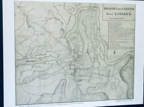
Fascinating Draught plan of the country around Limerick taken in 1752 by William Eyres Map Maker - the scale is at 320 yards to one inch.