-
Out of stock

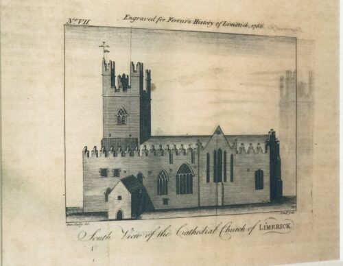
 35cm x 40cm Limerick City The definitive Ferrars History of Limerick was first published in 1787 There are very few copies still in existence and these 5 prints were generously taken from 16 original engravings in the first edition . Castleconnell, picturesquely situated on a rock overlooking the Shannon, about six miles north of Limerick, became the principal castle of the Bourkes in West Clanwilliam. This was the ancient seat of the O'Conaings, and took their name Caislean-ui-Chonaine. It subsequently fell into the possession of the O'Briens of Thomond. King John made a grant of Castleconnell, with five knights' fees, to William de Burgh, who erected a strong castle there. Walter De Burgh, about the end of the thirteenth century, considerably enlarged and strengthened this castle, which was the chief stronghold of his descendants at the end of the sixteenth century.The History of Limerick by James Ferrar published in 1787 is a history of Limerick city from ancient times until the late 18th century. Limerick was an important medieval stronghold, became an important port and trading centre, was subject to a series of sieges in the 17th century and finally experienced a brief golden age of prosperity during the Georgian period of the late 18th century. Limerick or Luimneach was an ancient settlement long before the Vikings captured it and established their own town there in the 9th century. They used it as a base for trade and also to launch raids up the River Shannon against monastic sites like Clonmacnoise and other wealthy Christian centres. However in the 11th century the last Viking king of Limerick was defeated by King Brian Boru. In 1174, the Norman conquerors who had already seized Dublin , Leinster and Munster captured the city of Limerick . It was given its city charter by King Richard I in 1197 and a castle fortress was built by King John about 1200. The medieval city featured a walled town known as Englishtown on the north side of the River Shannon. Irishtown was inhabited by the Irish and Vikings was on the south side of the river. Both were eventually walled and linked by bridges over the Shannon . Limerick would retain formidable defenses until the 17th century when it experienced four separate sieges during the period of the English Civil War and the Williamite Wars. Catholic rebels forced the English garrison to surrender in 1642 and a Parliamentarian Army in turn forced a Catholic and Royalist garrison to surrender in 1651. It was twice besieged in 1690 and 1691 by the forces of William III of Orange who forced Jacobins fighting on the sides of the Catholic James II to surrender and go into exile. From the late 17th to the 19th centuries an Anglo-Irish Protestant elite controlled Ireland . In Limerick in the late 1700s Limerick merchants prospered and Edmund Pery, 1st Viscount Pery had much of the south side of the city redesigned with a grid of Georgian brick terraces and neo-classical stone buildings. The Georgian area still survives in the 21st century and Prey Square is named in Edmund Prey's honour. Unfortunately the Irish economy declined in the early 19th century as the Irish Parliament was switched from College Green, Dublin to the House of Commons in London and Ireland remained a near feudal agricultural society as Britain rapidly industrialised. Like Dublin , Limerick 's best days were behind it as slums flourished and in the 1840s the city population swelled as the poor fled from the land after the failure of the potato crop.
 -
 St Marys Cathedral from Ferrars History of Limerick, first published in 1787.There are very few copies still in existence and these 5 prints were generously taken from 16 original engravings in the first edition 35cm x 40cm Limerick Limerick Cathedral (Saint Mary's) is dedicated to the Blessed Virgin Mary and was founded in 1168 and is the oldest building in Limerick which is in use. It has the only complete set of misericords left in Ireland. In 1111, the Synod of Ráth Breasail decided that "Saint Mary's church" would become the cathedral church of the Diocese of Limerick. According to tradition, Domnall Mór Ua Briain, the last King of Munster, founded the present cathedral on the site of his palace on King's Island in 1168.[3] The palace had been built on the site of the Viking meeting place, or "Thingmote" – the Vikings' most westerly European stronghold.[1] This had been the centre of government in the early medieval Viking city. Parts of the palace may be incorporated into the present structure of the cathedral, most prominently the great west door, which is claimed to have been the original main entrance to the royal palace.The west door is now only used on ceremonial occasions. The bishops of Limerick have for centuries knocked on this door and entered by it as part of their installation ceremony. According to tradition, during the many sieges of Limerick the defenders of the city used the stones around the west door to sharpen their swords and arrows, and the marks they made in the stonework can be seen there today. The tower of Saint Mary's Cathedral was added in the 14th century. It rises to 120 feet (36.58 meters), containing a peal of 8 bells, of which 6 were cast by John Taylor & Co, Loughborough, and 2 cast in Whitechapel, London. The tower also contains a stationary service bell, which can be rung from the ground floor.
Notable burials
-
 Bishop Charles Graves The cathedral graveyard contains many graves and tombs of notable people. The physician Samuel Crumpe is buried in the graveyard near the great west door. Prince Milo of Montenegro, Frances Condell (first woman Mayor of Limerick) and Bishop Charles Graves are also interred in the grounds. The last High King of Munster, Domnall was purportedly buried in the cathedral, with the remnants of his stone coffin still visible in the Cathedral chancel. Bishop Cornelius O'Dea is buried alongside several other Bishops of Limerick in what is believed to be an Episcopal vault underneath the chancel itself. Also notable are the Sexton, Barrington, Boyd and Vanderkiste tombs along the south entrance pathway.
From the Irish Reformation to the 19th century
There are five chandeliers which hang from the ceiling. These are only lit on special occasions. The larger three of the five were made in Dublin and presented in 1759 by the Limerick Corporation. The belfry holds a peal of eight bells, six of which were presented by William Yorke, mayor of Limerick, in 1673. An active team of bell ringers travels the country to compete with other campanologists.Saint Mary's received its organ in 1624, when Bishop Bernard Adams donated one. It has been rebuilt over the centuries and was most recently renovated in 1968 and 2005. In 1620 the English-born judge Luke Gernon, a resident of Limerick, wrote a flattering description of the cathedral: "not large, but lightsome, and by the providence of the Bishop fairly beautified within, and as gloriously served with singing and organs". During the Irish Confederacy wars, the cathedral was briefly transferred to Roman Catholic hands. The bishop of Limerick, Richard Arthur, was buried in the cathedral in 1646. Altar of the cathedralIn 1651, after Oliver Cromwell's forces captured Limerick, the cathedral was used as a stable by the parliamentary army. This misuse was short lived, but was a similar fate to that suffered by some of the other great cathedrals during the Cromwellian campaign in Ireland. The troops also removed the cathedral's original 13 ft Pre-Reformation high altar from the cathedral. The altar was only reinstated in the 1960s. It is the largest such altar in Ireland and the UK, carved from a single limestone block. The altar is used for communion services at major festivals and remains in its historic location in what is now the chapel of the Virgin Mary or Lady Chapel. In 1691, the cathedral suffered considerable damage, particularly on the east end, during the Williamite Siege of Limerick.After the Treaty of Limerick, William granted £1,000 towards repairs. There are cannonball from 1691 in the Glentworth Chapel/Saint George's Chapel inside.
 Choir misericords
From the 19th century to the 20th century
In 1968, the Irish Government commissioned two postage stamps to commemorate the cathedral's 800 year anniversary. A picture of one of the stamps is displayed on this page. In 1991, there was a large £2.5 million restoration programme which was completed in 1996 with the excavation and re-laying of the floors as well as the installation of underfloor central heating. Restoration continues today to a lesser degree. Postage Stamp from 1968
From the 20th century to the 21st century
Today the cathedral is still used for its original purpose as a place of worship and prayer for everybody. It is also the 3rd biggest tourist attraction in Limerick. It is open to the public every day from 9:00 am to 4:45 pm. For Tourists there is a €5 admission charge upon entry. This money is essential for the upkeep of the building, and without it, the cathedral simply could not function. Following the retirement of the Very Rev'd Maurice Sirr on 24 June 2012, Bishop Trevor Williams announced the appointment of the Reverend Sandra Ann Pragnell as Dean of Limerick and Rector of Limerick City Parish. She was the first female dean of the cathedral and rector of Limerick City Parish, and retired in January 2017. It was announced on 27 August 2017, that the Reverend Canon Niall James Sloane was to become the 63rd Dean of Limerick and the new rector of Limerick City Parish; with his installation and institution taking place on 21 October 2017 in the cathedral. The cathedral grounds holds United Nations Memorial Plaque with the names of all the Irish men who died while serving in the United Nations Peacekeepers.The History of Limerick by James Ferrar published in 1787 is a history of Limerick city from ancient times until the late 18th century. Limerick was an important medieval stronghold, became an important port and trading centre, was subject to a series of sieges in the 17th century and finally experienced a brief golden age of prosperity during the Georgian period of the late 18th century. Limerick or Luimneach was an ancient settlement long before the Vikings captured it and established their own town there in the 9th century. They used it as a base for trade and also to launch raids up the River Shannon against monastic sites like Clonmacnoise and other wealthy Christian centres. However in the 11th century the last Viking king of Limerick was defeated by King Brian Boru. In 1174, the Norman conquerors who had already seized Dublin , Leinster and Munster captured the city of Limerick . It was given its city charter by King Richard I in 1197 and a castle fortress was built by King John about 1200. The medieval city featured a walled town known as Englishtown on the north side of the River Shannon. Irishtown was inhabited by the Irish and Vikings was on the south side of the river. Both were eventually walled and linked by bridges over the Shannon . Limerick would retain formidable defenses until the 17th century when it experienced four separate sieges during the period of the English Civil War and the Williamite Wars. Catholic rebels forced the English garrison to surrender in 1642 and a Parliamentarian Army in turn forced a Catholic and Royalist garrison to surrender in 1651. It was twice besieged in 1690 and 1691 by the forces of William III of Orange who forced Jacobins fighting on the sides of the Catholic James II to surrender and go into exile. From the late 17th to the 19th centuries an Anglo-Irish Protestant elite controlled Ireland . In Limerick in the late 1700s Limerick merchants prospered and Edmund Pery, 1st Viscount Pery had much of the south side of the city redesigned with a grid of Georgian brick terraces and neo-classical stone buildings. The Georgian area still survives in the 21st century and Prey Square is named in Edmund Prey's honour. Unfortunately the Irish economy declined in the early 19th century as the Irish Parliament was switched from College Green, Dublin to the House of Commons in London and Ireland remained a near feudal agricultural society as Britain rapidly industrialised. Like Dublin , Limerick 's best days were behind it as slums flourished and in the 1840s the city population swelled as the poor fled from the land after the failure of the potato crop. -
-
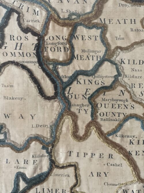
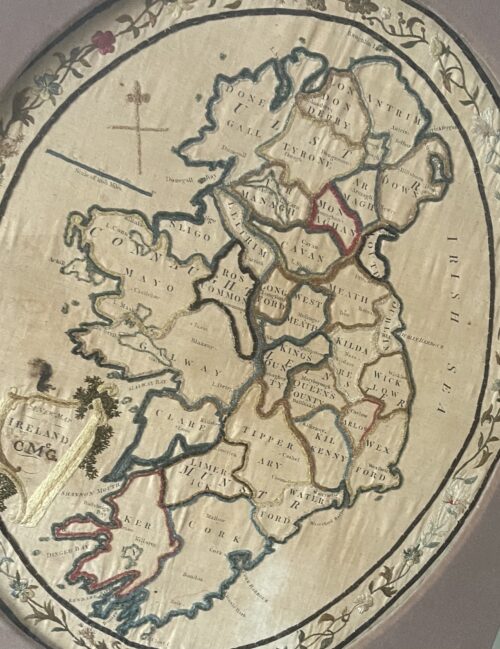 Very interesting and superbly framed New Map of Ireland from 1779 ( CMcG) from the latest surveys of the time.Please contact us directly at irishpubemporium@gmail.com for pricing and shipment quotation for this extraordinarily rare item. Offset in a display type frame made by The Dawson Gallery 4 Dawson Street Dublin 2, we estimate this piece to be well over 200 years old.Long obsolete place names such as the ancient baronies of Blakeny Co Galway,Rofs Co Cork,Philipstown Co Laois and spellings such as Donegall,Lough Deirg & support this estimate. 70cm x 60cm Dublin
 -
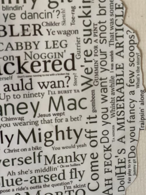
 40cm x 33cm Co Cork
Every country has its own slang terms or local colloquialisms and Ireland is no different. Many of the country's famous sayings are well-known worldwide, but there may be one or two you're not familiar with. No doubt you'll be wanting to experience the 'craic' for yourself as you explore your new surroundings, so we've put together this 'bang-on' guide to the local lingo!
Craic is probably the most popular and familiar slang phrase, simply meaning ‘fun’ or ‘banter’, just good times. It has origins with the Ulster Scots, who told of the crack, the Gaelic spelling not fully popularised in Ireland until the 1970s, when it was the catchphrase of the Irish-language TV show SBB ina Shuí.
Some other slang phrases might not be quite as familiar, and each region of Ireland has its own particular lingo, but here are some of the weird and wonderful words and phrases that might come in handy, and save you from making an eejit or a gowl of yourself!Gowl: An annoying person. Ah, ye GOW-EL ye!
Wisht: Shush! A handy one for in the cinema, or for chatterboxes in lectures.
Scarlet: Embarrassed. Hopefully not because you’ve been a gowl. I was such an eejit, I was scarlet!
Wired to the moon: Maybe you’ve been out late, enjoying the craic a little too much, and you’ve grabbed a triple espresso on the way to the lecture theatre? You’re wired to the moon.
Wee: Small, but everything in Ireland is wee. If Dwayne ‘The Rock’ Johnson were to visit Ireland, he’d be Wee Dwayne.
Quare: Meaning ‘great’. It’s quare weather out today! Also used for ‘very’. It’s quare warm today!
Savage: Something excellent. Was it a good craic last night? Oh, it was savage!
The Jacks: The toilets, fir jacks for the mens, ban jacks for the ladies, not to be confused with…
Banjaxed: Broken. Ruined.
Happy out: Simply happy. You’re enjoying the craic, having a quare old time, you’re happy out.
Sure look at it: A suitable reply to nearly any statement. Isn’t this weather grand? Ah, sure look at it!
Ossified: Very drunk. Regretfully so. See also: langers, blathered, locked.
The messages: If you hear people referring to doing the messages, they're going shopping. Does anyone need anything? I’m heading out to do the messages.
The press: An Irish term for the cupboard. You might want to check you’ve enough biscuits in the press, before you set off to do the messages.
Are you okay?: If the barman is asking you this, he’s not checking on your state of being, simply wanting to know what you want to order.
I’ve a throat on me: Thirsty. Just don’t get too ossified and make an eejit of yourself!
Me ould segotia, me ould sweat, me ould flower: Best friend.
Aculsha: An old term of affection, from a chuisle mo chroí, ‘pulse of my heart’
A soft day: A drizzly rainy, misty day.
Acting the maggot: Being silly, making a nuisance. An annoying person.
Making a bags of it: Making a mess of something.
Cat altogether: Something bad. If the weather is terrible, it could be cat altogether out there.
Even if you’re apprehensive about using some of these phrases in your conversations, it’ll certainly help you understand what your new Irish friends are saying. Ah, it was quare warm yesterday, I’d meant to do the messages, but I’d quite the throat on me. I got utterly langers, made a right gowl of meself acting the maggot, and I’m totally banjaxed today. Savage! -
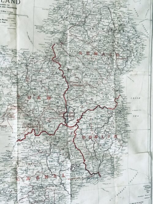
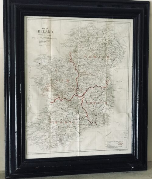 Superb 1940s era vintage original map showing the dioceses(!) and provinces of Ireland published by J.Duffy & Co.Ltd Westmoreland St Dublin. James Duffy (1809 – 4 July 1871) was a prominent Irish author and publisher. Duffy's business would become one of the major publishers of Irish nationalist books, bibles, magazines, Missals and religious texts throughout the 19th and 20th centuries. He was also a major publisher of Irish fiction.[1] He was described as having "invented a new kind of cosy family Catholicism. Duffy was born in Monaghan. He was educated at a hedge school and began his business as a bookseller through purchasing Protestant bibles given to Catholics. He then traveled to Liverpoolwhere he traded them for more valuable books. In 1830 he founded his own company, James Duffy and Sons and issued Boney's Oraculum, or Napoleon's Book of Fate, which experienced huge sales. Boney's Oraculum would later be the object of an allusion in a speech of Capt. Boyle in Seán O'Casey's 1924 play Juno and the Paycock. Another great editorial success was achieved when he collaborated with Charles Gavan Duffy (no relation) from 1843 to 1846 to publish poetry from the writers of The Nation. By the 1860s he was employing 120 staff members at his various enterprises in Dublin.[4] In 1860 he started Duffy's Hibernian Magazine, edited by Martin Haverty. It was a monthly, price eight pence, and ran for two years. The contributors included Charles Patrick Meehan, Julia Kavanagh, Denis Florence MacCarthy, John O'Donovan, William Carleton, Thomas D'Arcy McGee, and William John Fitzpatrick, and the articles were all signed. A second series began in 1862, renamed Duffy's Hibernian Sixpence Magazine, with Meehan as editor, which extended to six volumes and ended in June 1865. These and other relatively cheap magazines took advantage of the new-found confidence in home-grown literature and also offered an outlet for Irish authors. Among the magazines he published were:
- Duffy's Irish Catholic Magazine (1847)
- Catholic Guardian
- Christian Family Library
- Duffy's Hibernian Magazine
- Illustrated Dublin Journal
- Duffy's Fireside Magazine: A Monthly Miscellany (November 1850 – October 1852) (price: 4d)
- Duffy's Hibernian Sixpence Magazine (ceased publication in 1864)
- The Spirit of the Nation. Ballads and Songs by the Writers of The Nation, with Original and Ancient Music (1845)
- The Poetry of Ireland. Further collections from the writers of The Nation (1845-1846)
- The Ballad Poetry of Ireland
- The Book of Irish Ballads
- an 1861 edition of the Douay Bible, a copy of which is owned by the Central Catholic Library in Dublin
- John O'Hart, Irish landed gentry: when Cromwell came to Ireland (Dublin: James Duffy & Sons, 1887)
- John O’Hanlon, Lives of the Irish Saints, Vol 6 (James Duffy and Sons, 1891)
- Gerald Griffin The Invasion (Dublin, James Duffy & Sons)
Rival surveyors Ornamentation and embellishment of estates, especially from the middle of the eighteenth century, employed an expanding army of architects, landscape gardeners, painters, stuccadores, agriculturists, as well as lawyers and agents. Included with these personnel were surveyors and cartographers commissioned by landowners to produce maps both functional and ornamental for the estate office or the drawing room. Indeed later in the century, in the demographic scramble for land, surveyors were frequently also engaged by both owners and tenants to ‘squeeze’ a few more acres out of estate or farm. So active was the market that surveyors vied with each other in producing the most accurate maps. Many of their disputes were personal and public. In the middle of the century, Joshua Wight was called a dunce by a rival. As early as 1716, William Starrat knew that his calculation of forty acres for Inishmakill townland in Fermanagh would ‘be disputed, because Mr Moore’s survey made it only eighteen acres; and besides it is the opinion of a great many that knows the island that it contains about twenty acres. As for Mr Moore’s account, there is no ground for depending on it, because he only viewed it from the mainland and no man can measure an irregular plain at a distance.’ The number of surveys increased as the eighteenth century progressed reflecting expanding estate income and rural economic activity. As with architects and landscape designers, there was a community of surveyors distinguished from each other by their talents, reflected in turn by their fees. Their work ranged from modest, even mediocre and poor surveys, which were poorly realised and often inaccurate, to superlative and innovative productions of great beauty and accuracy. Presumably smaller, less well-off proprietors could only afford the more mediocre efforts. ‘Country surveyors’ worked at local level producing surveys for tenant farmers, assisting with bog divisions, laying out the lines for new roads. The best cartographers like John Rocque and Bernard Scalé were engaged by great landowners like the Duke of Leinster or the Marquis of Downshire. Chain and circumferentor Surveying throughout the eighteenth century occurred against a background of practice inherited from the seventeenth where land had been let by townland. Townland boundary delineation and calculation of townland acreage thus became the main preoccupations of surveyors. The internal geography of townlands was of limited interest to landowners and thus to surveyors, much to the frustration of later historians. Surveyors were seldom innovative; Petty’s style of mapping overshadowed eighteenth-century surveys. Indeed he remained dominant in most theoretical and practical aspects of surveying and little changed in its understanding for a century after him—the chain and circumferentor were still the main tools of the trade in the 1750s (Fig.2). The chain was used for horizontal measurements. The circumferentor was a somewhat obsolete instrument used for plotting angles. Apart from a frequent lack of standardisation in instruments, there was also a regional variation in units of measurement: Irish, plantation and English acres (and perches) were in use, though by the end of the century surveyors increasingly provided measurements in both Irish and statute acres. One of the earliest innovators was Thomas Raven, who had worked with the Ulster plantation producing some fine maps to accompany surveys of the new settlements. Later on he produced estate maps for a number of landowners in Munster and Connacht. The Earl of Essex engaged him to produce a survey of his lands in Farney in south Monaghan which provide a unique glimpse of this Gaelic and slightly planted landscape in 1634 (Fig.3). His maps, in atlas format, show tates (modern townlands) together with more than 400 hundred cabins and houses, wells, mills, churches, as well as indications of land quality within the townland units. Unforunately this amount of detailing of local landscapes did not continue as standard practice with Irish surveyors in the eighteenth century . Boundaries Surveys were undertaken for many reasons—to accompany the sale of property, the settlement of disputes, succession to the estate, leasing of holdings or the introduction of new management. The principal objective of the surveys was to determine the extent of the property in terms of boundaries or areal extent, with a sometimes secondary purpose of measuring land quality. In the later seventeenth and early eighteenth centuries, disputes about land boundaries frequently occurred between landowners—a throwback to the hastily completed surveys of the plantation periods. Raven’s map of Farney, for instance, contains a number of boundaries on the northern limits of the estate marked ‘in controversie’. These disputes were generally settled by survey and agreement. Interestingly later in the eighteenth century and into the nineteenth, the focus of disagreement on boundaries moved from estate to farm level, with frequent disputes arising between tenants and their neighbours or landlords. The burning of land after cropping was an opportune time for measurement. Landowners were frequently called in to adjudicate between disputing tenants who often employed local surveyors to advance their case. Before the establishment of fixed hedges, there were many opportunities for disputes. Starrat’s surveys in the 1730s in the Fermanagh and Leitrim refer to the difficulites of selecting definitive bearings. In the rapid population expansion of the late eighteenth century, landlords often employed surveyors to lay out enclosures. For example, in the 1820s Shirley in Monaghan was engaged in laying out new field boundaries and in persuading his tenantry to plant quicksets. More often than not the lines of main hedges were laid down by the estate surveyor, with the tenant given freedom to subdivide their farms themselves. Frequently tenants employed local surveyors to help with this.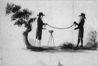
Fig.2 The chain and circumferentor were still the main tools of the trade in the 1750s. (Courtesy of the National Library of Ireland)
Rents and leases The falling in of leases in many parts of the country throughout the eighteenth century often revealed to the landowner extensive layers of subtenants who had fractured the land into smaller farms and enclosures. These were frequently taken on as tenants under the head landlord and their farms surveyed and mapped. Maps by Bernard Scalé of the Bath estate in Monaghan and the Devonshire estate in Waterford (Fig.4) were commissioned in the 1770s to assess the nature of change in settlement. In many cases, leases were granted at irregular intervals and landowners had to wait the falling-in of each lease. Great estate owners like Bath, Devonshire or Downshire would, however, undertake a complete survey of their estate and subsequently try to lease out most of their property in one letting. The more common practice, however, was to have individual farm surveys or portions of estates mapped. Also, agricultural development meant re-valuation of land: typically, drainage and wasteland reclamation in the later eighteenth century called for map and rent revisions. In these instances surveyers with their chains and painted pegs were unpopular with tenants who saw them as precursors of rent increases. In prefamine decades, their every move in the countryside was closely watched as the overcrowded acres, roods and perches, were meticulously measured out. John Rocque From the middle of the eighteenth century especially, estate improvements frequently involved extravagant investment in the landowner’s private gardens and demesnes. Elaborate maps of these were often produced to match the picturesque views frequently commissioned from fashionable painters. The maps of John Rocque probably represent the most artistic achievement of a cartographer in eighteenth-century Ireland. Rocque (c.1705-1762) was a member of the French Huguenot community in England who established a reputation as a superlative cartographer, with highly-regarded surveys of London, Paris and Rome to his credit. He was invited to Ireland by a number of Irish noblemen in 1754, mainly with the objective of undertaking a survey of Dublin. This he accomplished in 1756 and his map remains an unsurpassed record of Georgian Dublin (a fragment of which was reproduced on the old £10 note). Rocque was to revolutionise cartography and surveying in Ireland in the space of six years in the 1750s, so much so that in the 1820s, surveyors in Ireland were still being described as belonging to ‘the French school of Rocque’. The hallmark of his cartography was an unprecedented amount of fine detail on the cities and landscapes he mapped. His surveys were carried out by a small team of apprentices who helped to transmit Rocque’s ideas and techniques to the following generations of Irish surveyors. His most notable pupil and successor was Bernard Scalé, who established himself as a well known surveyor in the later eighteenth century (Fig.4). While Rocque was producing the printed surveys of Dublin and other Irish towns, he was also engaged by a number of Irish landlords to map their estates. His most important patron was the twentieth Earl of Kildare (later first Duke of Leinster) who lived at Carton outside Maynooth, and who owned 67,000 acres in a number of manors scattered throughout County Kildare. At the time of the survey (1757), Lord and Lady Kildare were in the process of radically transforming their house and environs in Maynooth. The architect Richard Castle (responsible for designing numerous great houses throughout Ireland) was involved in the remodelling of Carton. The Francini brothers were engaged to decorate the ceilings. So it is a tribute to Rocque’s exceptional reputation that he was involved with some of the most famous and fashionable artists and craftsmen in the transformation of Carton into one of the foremost palladian mansions in the country.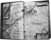
Fig.3 Carrickmacross, from Thomas Raven’s survey of Essex estate, County Monaghan 1634-5. Note the cluster of cabins, center right. (Courtesy of Marquis of Bath)
Kildare estates The survey of the Kildare estates was produced in eight atlas volumes, each page containing individual maps of the townlands. This set of maps was subsequently dispersed and the maps of Maynooth Manor are currently held in the University Library, Cambridge. A recently-discovered wall map of Maynooth Manor now hangs in Maynooth College. Apart from minor details, it is essentially a replica, drawn on a large sheet, of the album format and may have been produced by Rocque as a working map for the estate office or as a decoration for the house at Carton. The Maynooth map is very characteristic of Rocque—showing the landscape almost as it might have looked from the air. It contains typical detail such as the cartouche with a view of Maynooth Castle. There is wide-ranging detail provided in each townland. Relief is shown by hachures in grey, water (including ditches) by a blue wash. Buildings are shown in block plan—a Rocque innovation—contrasting with earlier, more impressionistic pictorial conventions for buildings. In some of these, the farmyards containing hay or straw stacks are shown. Arable land is usually brown with stippling to represent ridges or furrows, though the full meaning of his code of symbols is still a mystery. Meadow and pasture are shown in light green. Tree symbols show orchards and woodlands; hedges are depicted by lines of bushes. In some areas, fences without hedging are shown by means of a grey herring-bone device. There are also springs, mills, quarries, forges, pigeon houses, prehistoric forts and field names. Each field is numbered in sequence within each townland, and details of the area, and sometimes the content of the field, are given in the reference panel.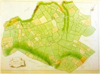
Fig.4 The manor of Tallow 1774 – part of Bernard Scale’s survey of County Waterford’s Devonshire estates. (Courtesy of the Trustees of the Chatsworth Settlement)
Landscape embellishment The Carton section of the map shows clearly the demesne landscape as it was emerging from its reorganisation by Lady Kildare. As daughter of the Duke of Richmond she was well connected in England. ‘Capability’ Brown, the great English landscape gardener of the eighteenth century was unable to come to Carton, but she engaged other important designers, including a disciple of Brown’s, to create a park landscape which is still of international significance. Rocque has the distinction, therefore, of recording the embryonic parkland on a map which complements a 1753 painting by Arthur Devis depicting Lord and Lady Kildare overseeing their plans for Carton, and other landscape views by Thomas Roberts—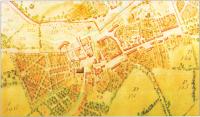
Fig.5 The town of Maynooth, County Kildare, from John Roque’s 1757 survey. (Courtesy of Patrick’s College, Maynooth)
all elements of ostentatious showing-off of house and demesne in the highly status-sensitive society of the eighteenth century. The map shows the house and yards much as they are today. The walled garden is depicted with its interior detail. The lake had not yet been made—it had to await the damming of the Rye Water stream in the 1760s. Maynooth town (Fig.5) is shown at one of the major turning points in its history. What Rocque recorded was the almost medieval huddle of houses around the castle, with the main Galway road still in evidence passing through the toll gatehouse at the castle. However, at the east of the town, symbolically joining the avenue which led to Carton, is evidence of the beginning of the new town plan of Maynooth, with the newly laid-out main street as we have inherited it today. In what are now the grounds of Maynooth College, there are some curious ornamental (vegetable?) gardens reminiscent of earlier classical designs. Rocque’s legacy to Irish surveying and cartography is affirmed in a succession of later maps of Carton, which was possibly his first and certainly his most important private surveying undertaking. In 1769 his distinguished successor, Bernard Scalé, produced a superb map of the demesne at ten perches to the inch. In 1821, a volume of maps of the ‘Mannor of Maynooth’ (including Carton Park) was produced by Sherrard, Brassington and Greene (Fig.6). This was a leading firm of surveyors in early nineteenth-century Ireland and Thomas Sherrard had been a pupil of Scalé. Conclusion Although the eighteenth century is regarded as poorly supplied with primary sources, the growing accessibility of private estate papers is helping to expand the coverage and knowledge of this period. Estate surveys are an especially important components in these private collections. The changing landscape which they record is one of the most notable characteristics of the eighteenth-century ‘age of improvement’, because all the radical social and economic transformations of the age were inscribed indelibly on the Irish landcape of town and country. The later comprehensive maps of the Ordnance Survey recorded the landscape at the end of this cycle of change, though fortunately before the traumatic changes which accompanied the Famine. Although questions on the representativeness of extant estate maps are valid, those that have survived may provide valuable information on the extent and nature of enclosures, on changes in settlement patterns, on the evolution of placenames, on the development of road networks. Many of the surveys show house locations and although it is possible that many cabins were omitted or mapped inconsistently more systematic analysis of estate maps might throw light on the process of demographic expansion in the century before the Famine. Origins : Co Clare Dimensions :65cm x 55cm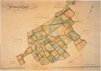
Fig.6 Graigsallagh, from a volume of maps of the ‘Manor of Maynooth'(1821) by Sherrard, Brassington and Green. (Courtesy of carton Desmesne)
-
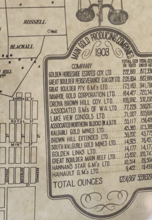
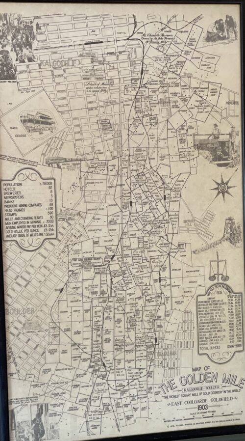 33cm x 57cm In the winter of 1893, prospectors Patrick (Paddy) Hannan, Tom Flanagan, and Dan Shea were travelling to Mount Youle, when one of their horses cast a shoe. During the halt in their journey, the men noticed signs of gold in the area around the foot of what is now the Mount Charlotte gold mine, located on a small hill north of the current city, and decided to stay and investigate. On 17 June 1893, Hannan filed a Reward Claim, leading to hundreds of men swarming to the area in search of gold, and Kalgoorlie, originally called Hannan's Find, was born.The population of the town was 2,018 (1,516 males and 502 females) in 1898. The mining of gold, along with other metals such as nickel, has been a major industry in Kalgoorlie ever since, and today employs about one-quarter of Kalgoorlie's workforce and generates a significant proportion of its income. The concentrated area of large gold mines surrounding the original Hannan's find is often referred to as the Golden Mile, and was sometimes referred to as the world's richest square mile of earth. In 1901, the population of Kalgoorlie was 4,793 (3,087 males and 1,706 females) which increased to 6,790 (3,904 males and 2,886 females) by 1903. The 3 ft 6 in (1,067 mm) narrow-gauge Government Eastern Goldfields Railway line reached Kalgoorlie station in 1896, and the main named railway service from Perth was the overnight sleeper train The Westland, which ran until the 1970s. In 1917, a 4 ft 8+1⁄2 in(1,435 mm) standard gauge railway line was completed, connecting Kalgoorlie to Port Augusta, South Australia, across 2,000 kilometres (1,243 mi) of desert, and consequently the rest of the eastern states. The standardisation of the railway connecting Perth (which changed route from the narrow-gauge route) in 1968 completed the Sydney–Perth railway, making rail travel from Perth to Sydney possible; the Indian Pacific rail service commenced soon after. During the 1890s, the Goldfields area boomed as a whole, with an area population exceeding 200,000, composed mainly of prospectors. The area gained a reputation for being a "wild west", notorious for its bandits and prostitutes. This rapid increase in population and claims of neglect by the state government in Perth led to the proposition of the new state of Auralia, but with the sudden diaspora after the Gold Rush, these plans fell through. Places, famous or infamous, for which Kalgoorlie is noted include its water pipeline, designed by C. Y. O'Connor and bringing in fresh water from Mundaring Weir near Perth, its Hay Street brothels, its two-up school, the goldfields railway loopline, the Kalgoorlie Town Hall, the Paddy Hannan statue/drinking fountain, the Super Pit, and Mount Charlotte lookout. Its main street is Hannan Street, named after the town's founder. One of the infamous brothels also serves as a museum and is a major national attraction. Paddy Hannan was the son of John Hannan and Bridget Lynch, and was baptised on 26 April 1840 in the town of Quin, County Clare, Ireland. His baptismal record shows that his godparents (sponsors) were Margaret Lynch and John O'Brien. Many of the people in his family emigrated to Australia from 1852 onwards, and close ties were maintained. Two of Hannan's nieces would welcome Hannan into their house for the last years of his life. Hannan emigrated to Australia when he was 22, arriving in Melbourne on 23 December 1862 aboard the Henry Fernie from Liverpool. He is recorded in the passenger list as Pat Hannan, a labourer.
 Hannan Street in September 1930; the Exchange Hotel is at the centre, with the Palace Hotel on the right.
Prospecting success
In 1893 in Western Australia, Hannan and his partners were the first to find gold near Mount Charlotte, less than 40 kilometres from the existing Coolgardie Goldfields. Hannan, Flanagan and Shea were following a large number of prospectors who set out for a rumoured new prospect at Mount Youle. One version of the story of the find has it that on the night of 14 June 1893, Hannan found gold in a gully. Not wanting to cause a rush, he concealed the find. During the night the trio moved one of their horses into the scrub. The following morning Hannan informed the main party they were going to stay behind to find their lost horse. After the main group moved off east, the three men started to pick up the gold and peg out their lease. Amongst the various counter-claims to emerge over the years, one lively version of the story was told in 1909 by Fred Dugan (another prospector, who was present at the time) relating how Thomas Flanagan found the first nuggets, and covered his find with brushwood to conceal it until the following day. By law, those finding "payable" gold were required to report the fact to the warden's office within seven days, so Hannan set off for Coolgardie to register their find, doing so on 17 June 1893. It has been suggested that Hannan, rather than Flanagan or Shea, was chosen to officially register the claim because only he could read and write, but there is evidence that Flanagan was literate, since, in 1864, he had clearly signed the official death certificate of his brother John Flanagan, and had written his own place of residence at the time - White Hills (in Bendigo, Victoria, Australia). The other possible reasons for Hannan going alone to the office at Coolgardie are set out by Martyn Webb,who relates that: Hannan's Western Australian miner's right, 1893
The fact that Flanagan and Shea were able to secure another 100 ounces while Hannan was away registering their claim at Coolgardie might help to explain why Hannan was chosen ... simply because they were better at specking than he was – it needs good eyesight. On the other hand, since the journey was arduous and had to be done as quickly as possible, Hannan might have been chosen because, as Uren and others suggest, he was the youngest and the fittest of the three. … The most likely reason … was that he was the undisputed leader of the party.
Hannan registered the claim in Flanagan's name as well as his own. Within hours a stampede began. It was estimated that about 400 men were prospecting in the area within three days, and over 1,000 within a week.— Webb, p. 103Final years
In 1904, at the age of sixty-four, Hannan was granted an annual pension of £150 by the Government of Western Australia. Having searched for gold throughout his adult life, he did not cease his prospecting activities until after 1910, his seventieth year. At that time he went to live with two of his nieces in Fallon Street, Brunswick, Victoria (close to the city of Melbourne). He died there in 1925 and was buried in Melbourne Central Cemetery, in the Catholic section, near the North Gate. In 1993 his grave was restored by the citizens of Kalgoorlie, led by Tess Thomson, as a part of the celebration of the 100-year anniversary of the original find by Hannan, Flanagan and Shea. Hannan's grave in Melbourne Central Cemetery, Section Y
Legacy
In memory of a man who is regarded as the founder of Kalgoorlie, the main street and a suburb in Kalgoorlie both bear Hannan's name, and in 1929 a statue of him by the sculptor John MacLeod was erected there. The city boasts several commemorative plaques to the three Irishmen, Hannan, Flanagan and Shea. A popular Irish pub at the Burswood Entertainment Complex was also named after Hannan. In Ireland there is a plaque dedicated to his memory opposite Quin Abbey, Quin, County Clare, and there is a bust with an explanatory dedication on display inside the DeValera Library in Ennis, County Clare. 1929 statue of Paddy Hannan in Kalgoorlie, Western Australia
 -
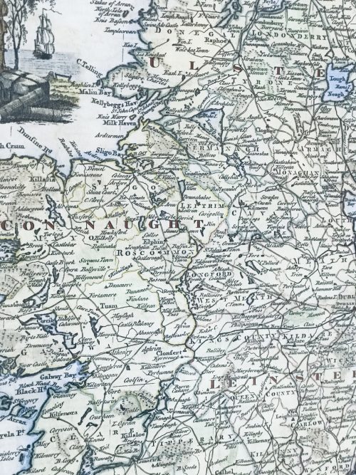
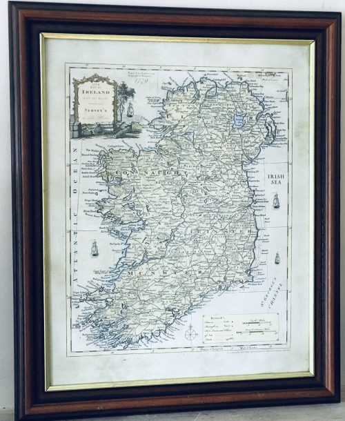 Very interesting and superbly framed Map of Ireland from 1779 from the latest surveys of the time. 62cm x 49cm Dublin
 -
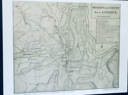
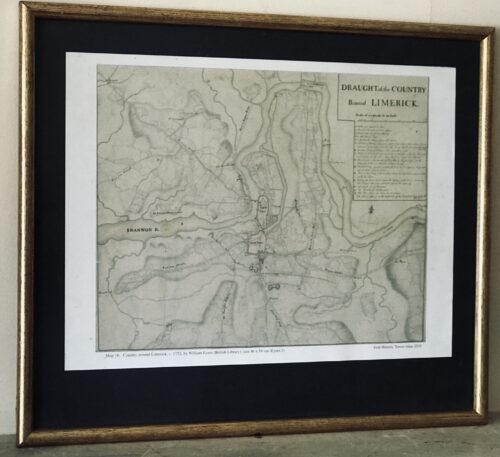 42cm x 48cm Limerick Fascinating Draught plan of the country around Limerick taken in 1752 by William Eyres Map Maker - the scale is at 320 yards to one inch.
 -
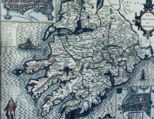
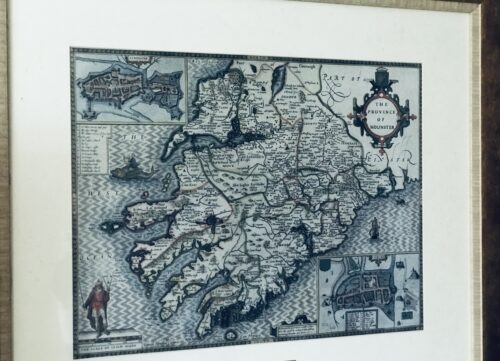 Fascinating map from 1610 as by the renowned cartographer John speed of the Province of Mounster(Munster!)-comprising the counties of Tipperary,Clare,Limerick,Cork,Kerry & Waterford.Includes miniature city layouts of both Limerick & Cork. 52cm x 65cm Beaufort Co Kerry John Speed (1551 or 1552 – 28 July 1629) was an English cartographer and historian. He is, alongside Christopher Saxton, one of the best known English mapmakers of the early modern period.
Life
Speed was born in the Cheshire village of Farndon and went into his father Samuel Speed's tailoring later in life. While working in London, Speed was a tailor and member of a corresponding guild, and came to the attention of "learned" individuals. These individuals included Sir Fulke Greville, who subsequently made him an allowance to enable him to devote his whole attention to research. By 1598 he had enough patronage to leave his manual labour job and "engage in full-time scholarship". As a reward for his earlier efforts, Queen Elizabethgranted Speed the use of a room in the Custom House. Speed, was, by this point, as "tailor turned scholar" who had a highly developed "pictorial sense". In 1575, Speed married a woman named Susanna Draper in London, later having children with her. These children definitely included a son named John Speed, later a "learned" man with a doctorate, and an unknown number of others, since chroniclers and historians cannot agree on how many children they raised. Regardless, there is no doubt that the Speed family was relatively well-off. By 1595, Speed published a map of biblical Canaan, in 1598 he presented his maps to Queen Elizabeth, and in 1611–1612 he published maps of Great Britain, with his son perhaps assisting Speed in surveys of English towns. At age 77 or 78, in August 1629, Speed died. He was buried alongside his wife in London's St Giles-without-Cripplegate church on Fore Street. Later on, a memorial to John Speed was also erected behind the altar of the church.According to the church's website, "[His was] one of the few memorials [in the church] that survived the bombing" of London during The Blitz of 1940–1941 ... The website also notes that "[t]he cast for the niche in which the bust is placed was provided by the Merchant Taylors' Company, of which John Speed was a member". His memorial brass has ended up on display in the Burrell Collection near Glasgow.Works
Speed drew historical maps in 1601 and 1627 depicting the invasion of England and Ireland, depictions of the English Middle Ages, along with those depicting the current time, with rough originals but appealing, colourful final versions of his maps. It was with the encouragement of William Camden that Speed began his Historie of Great Britaine, which was published in 1611. Although he probably had access to historical sources that are now lost to us (he certainly used the work of Saxton and Norden), his work as a historian is now considered secondary in importance to his map-making, of which his most important contribution is probably his town plans, many of which provide the first visual record of the British towns they depict.In the years leading up to this point, while his atlas was being compiled, he sent letters to Robert Cotton, part of the British government to ask for assistance in gathering necessary materials.His atlas The Theatre of the Empire of Great Britaine was published in 1611 and 1612, and contained the first set of individual county maps of England and Wales besides maps of Ireland and a general map of Scotland. Tacked onto these maps was an introduction at the beginning when he addressed his "well affected and favourable reader", which had numerous Christian and religious undertones, admitting that there may be errors, but he made it the best he could, and stated his purpose for the atlas: In 1627 George Humble published the Prospect of the Most Famous Parts of the World, printed by John Dawson. This is the world map from this atlas with John Speed's name in the title, but not attributed to Speed's authorship.
my purpose...is to shew the situation of every Citie and Shire-town only [within Great Britain]...I have separated...[with] help of the tables...any Citie, Towne, Borough, Hamlet, or Place of Note...[it] may be affirmed, that there is not any one Kingdome in the world so exactly described...as is...Great Britaine...In shewing these things, I have chiefly sought to give satisfaction to all.
With maps as "proof impressions" and printed from copper plates, detail was engraved in reverse with writing having to be put on the map the correct way, while speed "copied, adapted and compiled the work of others", not doing much of the survey work on his own, which he acknowledged.The atlas was not above projections of his political opinions" Speed represented King James I as one who unified the "Kingdoms of the British isles". In 2016, the British Library published a book, introduced by former MP Nigel Nicolson and accompanied by commentaries by late medieval and early modern historian Alasdair Hawkyard, which reprinted this collection of maps on the British Isles, showing that Speed had drawn maps of areas ranging from Bedfordshire to Norfolk and Wales. Most, but not all, of the county maps have town plans on them; those showing a Scale of Passes being the places he had mapped himself. In 1627, two years before his death, Speed published Prospect of the Most Famous Parts of the World which was the first world atlas produced by an Englishman, costing 40 shillings, meaning that its circulation was limited to "richer customers and libraries", where many survive to this day. There is a fascinating text describing the areas shown on the back of the maps in English, although a rare edition of 1616 of the British maps has a Latin text – this is believed to have been produced for the Continental market. Much of the engraving was done in Amsterdam at the workshop of a Flemish man named Jodocus Hondius, with whom he collaborated with from 1598 until 1612, with Hondius's sudden death, a time period of 14 years.His maps of English and Welsh counties, often bordered with costumed figures ranging from nobility to country folk, are often found framed in homes throughout the United Kingdom. In 1611, he also published The genealogies recorded in the Sacred Scriptures according to euery family and tribe with the line of Our Sauior Jesus Christ obserued from Adam to the Blessed Virgin Mary, a biblical genealogy, reprinted several times during the 17th century. He also drew maps of the Channel Islands, Poland, and the Americas, the latter published only a few years before his death. On the year of his death, yet another collection of maps of Great Britain he had drawn the year before were published. Described as a "Protestant historian", "Puritan historian" or "Protestant propagandist" by some, Speed wrote about William Shakespeare, whom he called a "Superlative Monster" because of certain plays, Roman conquest, history of Chester, and explored "early modern concepts of national identity". As these writings indicate, he possibly saw Wales as English and not an independent entity. More concretely, there is evidence that Speed, in his chronicling of history, uses "theatrical metaphors" and his developed "historiographic skill" to work while he repeats myths from medieval times as part of his story.Legacy
Since his maps were used in many high circles, Speed's legacy has been long-reaching. After his death, in 1673 and 1676, some of his other maps on the British isles, the Chesapeake Bay region, specifically of Virginia and Maryland, the East Indies, the Russian Empire then ruled by Peter the Great, Jamaica, and Barbados, among other locations.With these printings and others, Speed's maps became the basis for world maps until at least the mid-eighteenth century, with his maps reprinted many times, and served as a major contribution to British topography for years to come. In later years, Speed would be called "our English Mercator", a person of "extraordinary industry and attainments in the study of antiques", an "honest and impartial historian", a "faithful Chronologer", and "our Cheshire historian...a scholar...a distinguished writer on history".He was also called a "celebrated chronologer and histographer", "cartographer", and much more. Even today, prints of his "beautiful maps" can be found in living rooms across the world, and sell for hundreds of thousands of pounds in rare art and map auctions, drawing in map collectors across the globe.Additionally, some use John Speed's maps, and connected commentary, to interpret William Shakespeare's plays; however, Speed did not like Shakespeare in the slightest, and called him a "papist".
.jpg)