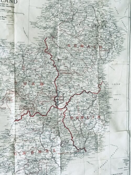
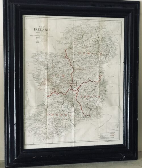
Superb 1940s era vintage original map showing the dioceses(!) and provinces of Ireland published by J.Duffy & Co.Ltd Westmoreland St Dublin.
James Duffy (1809 – 4 July 1871) was a prominent Irish author and publisher. Duffy's business would become one of the major publishers of
Irish nationalist books, bibles, magazines,
Missals and religious texts throughout the 19th and 20th centuries. He was also a major publisher of Irish fiction.
[1] He was described as having "invented a new kind of cosy family Catholicism.
Duffy was born in
Monaghan. He was educated at a hedge school and began his business as a bookseller through purchasing Protestant bibles given to Catholics. He then traveled to
Liverpoolwhere he traded them for more valuable books. In 1830 he founded his own company,
James Duffy and Sons and issued
Boney's Oraculum, or
Napoleon's Book of Fate, which experienced huge sales.
Boney's Oraculum would later be the object of an allusion in a speech of Capt. Boyle in
Seán O'Casey's 1924 play
Juno and the Paycock.
Another great editorial success was achieved when he collaborated with
Charles Gavan Duffy (no relation) from 1843 to 1846 to publish poetry from the writers of
The Nation.
By the 1860s he was employing 120 staff members at his various enterprises in Dublin.
[4] In 1860 he started
Duffy's Hibernian Magazine, edited by
Martin Haverty. It was a monthly, price eight pence, and ran for two years. The contributors included
Charles Patrick Meehan,
Julia Kavanagh,
Denis Florence MacCarthy,
John O'Donovan,
William Carleton,
Thomas D'Arcy McGee, and
William John Fitzpatrick, and the articles were all signed. A second series began in 1862, renamed
Duffy's Hibernian Sixpence Magazine, with Meehan as editor, which extended to six volumes and ended in June 1865. These and other relatively cheap magazines took advantage of the new-found confidence in home-grown literature and also offered an outlet for Irish authors.
Among the magazines he published were:
- Duffy's Irish Catholic Magazine (1847)
- Catholic Guardian
- Christian Family Library
- Duffy's Hibernian Magazine
- Illustrated Dublin Journal
- Duffy's Fireside Magazine: A Monthly Miscellany (November 1850 – October 1852) (price: 4d)
- Duffy's Hibernian Sixpence Magazine (ceased publication in 1864)
Duffy's magazines are seen as a forerunner of
Ireland's Own today.
Among books he published were:
- The Spirit of the Nation. Ballads and Songs by the Writers of The Nation, with Original and Ancient Music (1845)
- The Poetry of Ireland. Further collections from the writers of The Nation (1845-1846)
- The Ballad Poetry of Ireland
- The Book of Irish Ballads
- an 1861 edition of the Douay Bible, a copy of which is owned by the Central Catholic Library in Dublin
- John O'Hart, Irish landed gentry: when Cromwell came to Ireland (Dublin: James Duffy & Sons, 1887)
- John O’Hanlon, Lives of the Irish Saints, Vol 6 (James Duffy and Sons, 1891)
- Gerald Griffin The Invasion (Dublin, James Duffy & Sons)
The publishing house was based at 7 Wellington Quay, Dublin, and later at 14 & 15 Wellington Quay. James Duffy and Co. Ltd. of 38 Westmoreland Street was still in business in the late 20th century.
HISTORY OF MAPPING IN IRELAND:
Before the Ordnance Survey undertook the mapping of the country from Malin to Mizzen in the 1830s, cartography, surveying and landscape map production in Ireland were essentially a private undertakings. There had been a seventeenth-century precedent for state involvement in mapping in the various plantation surveys, but after Sir William Petty’s Down Survey (Fig.1) and the more or less final allocation of landed estates in the 1690s, there was no more central goverment involvement. Throughout the eighteenth century, competition in an expanding market for estate surveys produced a flowering of cartographic enterprise which has added considerably to our understanding of pre-famine social and economic development.
This explosion in estate maps, characterised by John Andrews as the ‘golden age of the Irish land surveyor’, was very much a reflection of agriculture-related economic expansion, the development of rural industry and the growth of settlement and landscape embellishment, which has for long been characterised in Europe as the ‘age of improvement’. Though interpretations of the period differ in focus, the landed estate became the principal agency through which economic and social change was mediated throughout the Irish landscape. As with most generalisations, this interpretation may mislead—estates varied enormously in size; many owners were non-resident either on their properties or in Ireland; and there were great contrasts in management order on different estates—but it is a useful model nonetheless.
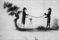
Fig.2 The chain and circumferentor were still the main tools of the trade in the 1750s.
(Courtesy of the National Library of Ireland)
Rival surveyors
Ornamentation and embellishment of estates, especially from the middle of the eighteenth century, employed an expanding army of architects, landscape gardeners, painters, stuccadores, agriculturists, as well as lawyers and agents. Included with these personnel were surveyors and cartographers commissioned by landowners to produce maps both functional and ornamental for the estate office or the drawing room. Indeed later in the century, in the demographic scramble for land, surveyors were frequently also engaged by both owners and tenants to ‘squeeze’ a few more acres out of estate or farm. So active was the market that surveyors vied with each other in producing the most accurate maps. Many of their disputes were personal and public. In the middle of the century, Joshua Wight was called a dunce by a rival. As early as 1716, William Starrat knew that his calculation of forty acres for Inishmakill townland in Fermanagh would ‘be disputed, because Mr Moore’s survey made it only eighteen acres; and besides it is the opinion of a great many that knows the island that it contains about twenty acres. As for Mr Moore’s account, there is no ground for depending on it, because he only viewed it from the mainland and no man can measure an irregular plain at a distance.’
The number of surveys increased as the eighteenth century progressed reflecting expanding estate income and rural economic activity. As with architects and landscape designers, there was a community of surveyors distinguished from each other by their talents, reflected in turn by their fees. Their work ranged from modest, even mediocre and poor surveys, which were poorly realised and often inaccurate, to superlative and innovative productions of great beauty and accuracy. Presumably smaller, less well-off proprietors could only afford the more mediocre efforts. ‘Country surveyors’ worked at local level producing surveys for tenant farmers, assisting with bog divisions, laying out the lines for new roads. The best cartographers like John Rocque and Bernard Scalé were engaged by great landowners like the Duke of Leinster or the Marquis of Downshire.
Chain and circumferentor
Surveying throughout the eighteenth century occurred against a background of practice inherited from the seventeenth where land had been let by townland. Townland boundary delineation and calculation of townland acreage thus became the main preoccupations of surveyors. The internal geography of townlands was of limited interest to landowners and thus to surveyors, much to the frustration of later historians. Surveyors were seldom innovative; Petty’s style of mapping overshadowed eighteenth-century surveys. Indeed he remained dominant in most theoretical and practical aspects of surveying and little changed in its understanding for a century after him—the chain and circumferentor were still the main tools of the trade in the 1750s (Fig.2). The chain was used for horizontal measurements. The circumferentor was a somewhat obsolete instrument used for plotting angles. Apart from a frequent lack of standardisation in instruments, there was also a regional variation in units of measurement: Irish, plantation and English acres (and perches) were in use, though by the end of the century surveyors increasingly provided measurements in both Irish and statute acres.
One of the earliest innovators was Thomas Raven, who had worked with the Ulster plantation producing some fine maps to accompany surveys of the new settlements. Later on he produced estate maps for a number of landowners in Munster and Connacht. The Earl of Essex engaged him to produce a survey of his lands in Farney in south Monaghan which provide a unique glimpse of this Gaelic and slightly planted landscape in 1634 (Fig.3). His maps, in atlas format, show tates (modern townlands) together with more than 400 hundred cabins and houses, wells, mills, churches, as well as indications of land quality within the townland units. Unforunately this amount of detailing of local landscapes did not continue as standard practice with Irish surveyors in the eighteenth century .
Boundaries
Surveys were undertaken for many reasons—to accompany the sale of property, the settlement of disputes, succession to the estate, leasing of holdings or the introduction of new management. The principal objective of the surveys was to determine the extent of the property in terms of boundaries or areal extent, with a sometimes secondary purpose of measuring land quality. In the later seventeenth and early eighteenth centuries, disputes about land boundaries frequently occurred between landowners—a throwback to the hastily completed surveys of the plantation periods. Raven’s map of Farney, for instance, contains a number of boundaries on the northern limits of the estate marked ‘in controversie’. These disputes were generally settled by survey and agreement.
Interestingly later in the eighteenth century and into the nineteenth, the focus of disagreement on boundaries moved from estate to farm level, with frequent disputes arising between tenants and their neighbours or landlords. The burning of land after cropping was an opportune time for measurement. Landowners were frequently called in to adjudicate between disputing tenants who often employed local surveyors to advance their case. Before the establishment of fixed hedges, there were many opportunities for disputes. Starrat’s surveys in the 1730s in the Fermanagh and Leitrim refer to the difficulites of selecting definitive bearings. In the rapid population expansion of the late eighteenth century, landlords often employed surveyors to lay out enclosures. For example, in the 1820s Shirley in Monaghan was engaged in laying out new field boundaries and in persuading his tenantry to plant quicksets. More often than not the lines of main hedges were laid down by the estate surveyor, with the tenant given freedom to subdivide their farms themselves. Frequently tenants employed local surveyors to help with this.
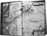
Fig.3 Carrickmacross, from Thomas Raven’s survey of Essex estate, County Monaghan 1634-5. Note the cluster of cabins, center right. (Courtesy of Marquis of Bath)
Rents and leases
The falling in of leases in many parts of the country throughout the eighteenth century often revealed to the landowner extensive layers of subtenants who had fractured the land into smaller farms and enclosures. These were frequently taken on as tenants under the head landlord and their farms surveyed and mapped. Maps by Bernard Scalé of the Bath estate in Monaghan and the Devonshire estate in Waterford (Fig.4) were commissioned in the 1770s to assess the nature of change in settlement. In many cases, leases were granted at irregular intervals and landowners had to wait the falling-in of each lease. Great estate owners like Bath, Devonshire or Downshire would, however, undertake a complete survey of their estate and subsequently try to lease out most of their property in one letting. The more common practice, however, was to have individual farm surveys or portions of estates mapped. Also, agricultural development meant re-valuation of land: typically, drainage and wasteland reclamation in the later eighteenth century called for map and rent revisions. In these instances surveyers with their chains and painted pegs were unpopular with tenants who saw them as precursors of rent increases. In prefamine decades, their every move in the countryside was closely watched as the overcrowded acres, roods and perches, were meticulously measured out.
John Rocque
From the middle of the eighteenth century especially, estate improvements frequently involved extravagant investment in the landowner’s private gardens and demesnes. Elaborate maps of these were often produced to match the picturesque views frequently commissioned from fashionable painters. The maps of John Rocque probably represent the most artistic achievement of a cartographer in eighteenth-century Ireland.
Rocque (c.1705-1762) was a member of the French Huguenot community in England who established a reputation as a superlative cartographer, with highly-regarded surveys of London, Paris and Rome to his credit. He was invited to Ireland by a number of Irish noblemen in 1754, mainly with the objective of undertaking a survey of Dublin. This he accomplished in 1756 and his map remains an unsurpassed record of Georgian Dublin (a fragment of which was reproduced on the old £10 note). Rocque was to revolutionise cartography and surveying in Ireland in the space of six years in the 1750s, so much so that in the 1820s, surveyors in Ireland were still being described as belonging to ‘the French school of Rocque’. The hallmark of his cartography was an unprecedented amount of fine detail on the cities and landscapes he mapped. His surveys were carried out by a small team of apprentices who helped to transmit Rocque’s ideas and techniques to the following generations of Irish surveyors. His most notable pupil and successor was Bernard Scalé, who established himself as a well known surveyor in the later eighteenth century (Fig.4).
While Rocque was producing the printed surveys of Dublin and other Irish towns, he was also engaged by a number of Irish landlords to map their estates. His most important patron was the twentieth Earl of Kildare (later first Duke of Leinster) who lived at Carton outside Maynooth, and who owned 67,000 acres in a number of manors scattered throughout County Kildare. At the time of the survey (1757), Lord and Lady Kildare were in the process of radically transforming their house and environs in Maynooth. The architect Richard Castle (responsible for designing numerous great houses throughout Ireland) was involved in the remodelling of Carton. The Francini brothers were engaged to decorate the ceilings. So it is a tribute to Rocque’s exceptional reputation that he was involved with some of the most famous and fashionable artists and craftsmen in the transformation of Carton into one of the foremost palladian mansions in the country.
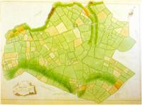
Fig.4 The manor of Tallow 1774 – part of Bernard Scale’s survey of County Waterford’s Devonshire estates.
(Courtesy of the Trustees of the Chatsworth Settlement)
Kildare estates
The survey of the Kildare estates was produced in eight atlas volumes, each page containing individual maps of the townlands. This set of maps was subsequently dispersed and the maps of Maynooth Manor are currently held in the University Library, Cambridge. A recently-discovered wall map of Maynooth Manor now hangs in Maynooth College. Apart from minor details, it is essentially a replica, drawn on a large sheet, of the album format and may have been produced by Rocque as a working map for the estate office or as a decoration for the house at Carton.
The Maynooth map is very characteristic of Rocque—showing the landscape almost as it might have looked from the air. It contains typical detail such as the cartouche with a view of Maynooth Castle. There is wide-ranging detail provided in each townland. Relief is shown by hachures in grey, water (including ditches) by a blue wash. Buildings are shown in block plan—a Rocque innovation—contrasting with earlier, more impressionistic pictorial conventions for buildings. In some of these, the farmyards containing hay or straw stacks are shown. Arable land is usually brown with stippling to represent ridges or furrows, though the full meaning of his code of symbols is still a mystery. Meadow and pasture are shown in light green. Tree symbols show orchards and woodlands; hedges are depicted by lines of bushes. In some areas, fences without hedging are shown by means of a grey herring-bone device. There are also springs, mills, quarries, forges, pigeon houses, prehistoric forts and field names. Each field is numbered in sequence within each townland, and details of the area, and sometimes the content of the field, are given in the reference panel.
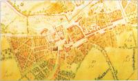
Fig.5 The town of Maynooth, County Kildare, from John Roque’s 1757 survey.
(Courtesy of Patrick’s College, Maynooth)
Landscape embellishment
The Carton section of the map shows clearly the demesne landscape as it was emerging from its reorganisation by Lady Kildare. As daughter of the Duke of Richmond she was well connected in England. ‘Capability’ Brown, the great English landscape gardener of the eighteenth century was unable to come to Carton, but she engaged other important designers, including a disciple of Brown’s, to create a park landscape which is still of international significance. Rocque has the distinction, therefore, of recording the embryonic parkland on a
map which complements a 1753 painting by Arthur Devis depicting Lord and Lady Kildare overseeing their plans for Carton, and other landscape views by Thomas Roberts—
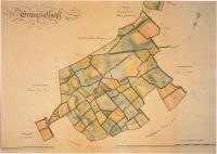
Fig.6 Graigsallagh, from a volume of maps of the ‘Manor of Maynooth'(1821) by Sherrard, Brassington and Green.
(Courtesy of carton Desmesne)
all elements of ostentatious showing-off of house and demesne in the highly status-sensitive society of the eighteenth century. The map shows the house and yards much as they are today. The walled garden is depicted with its interior detail. The lake had not yet been made—it had to await the damming of the Rye Water stream in the 1760s.
Maynooth town (Fig.5) is shown at one of the major turning points in its history. What Rocque recorded was the almost medieval huddle of houses around the castle, with the main Galway road still in evidence passing through the toll gatehouse at the castle. However, at the east of the town, symbolically joining the avenue which led to Carton, is evidence of the beginning of the new town plan of Maynooth, with the newly laid-out main street as we have inherited it today. In what are now the grounds of Maynooth College, there are some curious ornamental (vegetable?) gardens reminiscent of earlier classical designs.
Rocque’s legacy to Irish surveying and cartography is affirmed in a succession of later maps of Carton, which was possibly his first and certainly his most important private surveying undertaking. In 1769 his distinguished successor, Bernard Scalé, produced a superb map of the demesne at ten perches to the inch. In 1821, a volume of maps of the ‘Mannor of Maynooth’ (including Carton Park) was produced by Sherrard, Brassington and Greene (Fig.6). This was a leading firm of surveyors in early nineteenth-century Ireland and Thomas Sherrard had been a pupil of Scalé.
Conclusion
Although the eighteenth century is regarded as poorly supplied with primary sources, the growing accessibility of private estate papers is helping to expand the coverage and knowledge of this period. Estate surveys are an especially important components in these private collections. The changing landscape which they record is one of the most notable characteristics of the eighteenth-century ‘age of improvement’, because all the radical social and economic transformations of the age were inscribed indelibly on the Irish landcape of town and country. The later comprehensive maps of the Ordnance Survey recorded the landscape at the end of this cycle of change, though fortunately before the traumatic changes which accompanied the Famine.
Although questions on the representativeness of extant estate maps are valid, those that have survived may provide valuable information on the extent and nature of enclosures, on changes in settlement patterns, on the evolution of placenames, on the development of road networks. Many of the surveys show house locations and although it is possible that many cabins were omitted or mapped inconsistently more systematic analysis of estate maps might throw light on the process of demographic expansion in the century before the Famine.
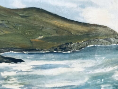
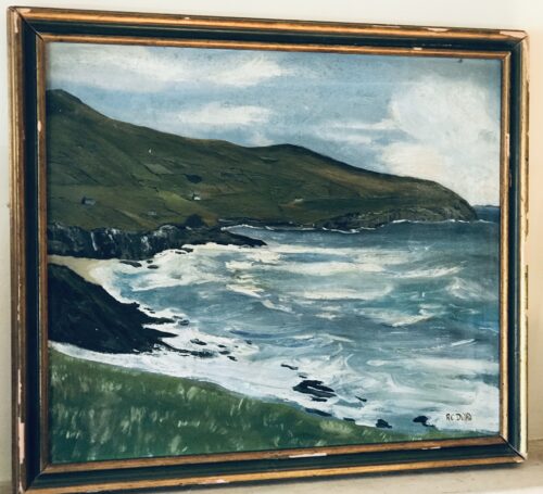
Origins : Co Clare
Dimensions :65cm x 55cm